Trail")
Heading through the September aspens at 8300 feet elevation on the WOW trail. First photos and review by Bruce on June 2, 2015. Last updated September 2018.
WoW (Wasatch Over Wasatch) TrailThe Wasatch Over Wasatch Trail will link Deer Valley to Wasatch Mountain State Park when complete.
12 miles are finished, starting across the road from the campground/day-use
area at Wasatch
Mountain State Park to an upper parking lot on SR 222 about a mile below
the Empire Pass road
fork. Riding season is late June through mid-October. Wasatch Mountain
State Park is a fee
area -- and this includes the entire canyon.
The trail is located in Pine Canyon north of Midway. Starting at 5850 feet elevation across
from the campground, the completed section hits 8350 feet altitude, drops
back to 8200 at Hardy
Lake, then resumes climbing to 8450 at the new SR 222 upper trailhead.
An out-and-back ride
is an advanced-level outing due to length, significant climbing, and some
rough trail surface.
A shuttled downhill requires upper-intermediate skills.

Ignore smaller branching trails in the first half-mile. These are nature trails extending up from the campground. At this bridge over Pine Creek, WOW is the bigger trail veering left. Photo in June.

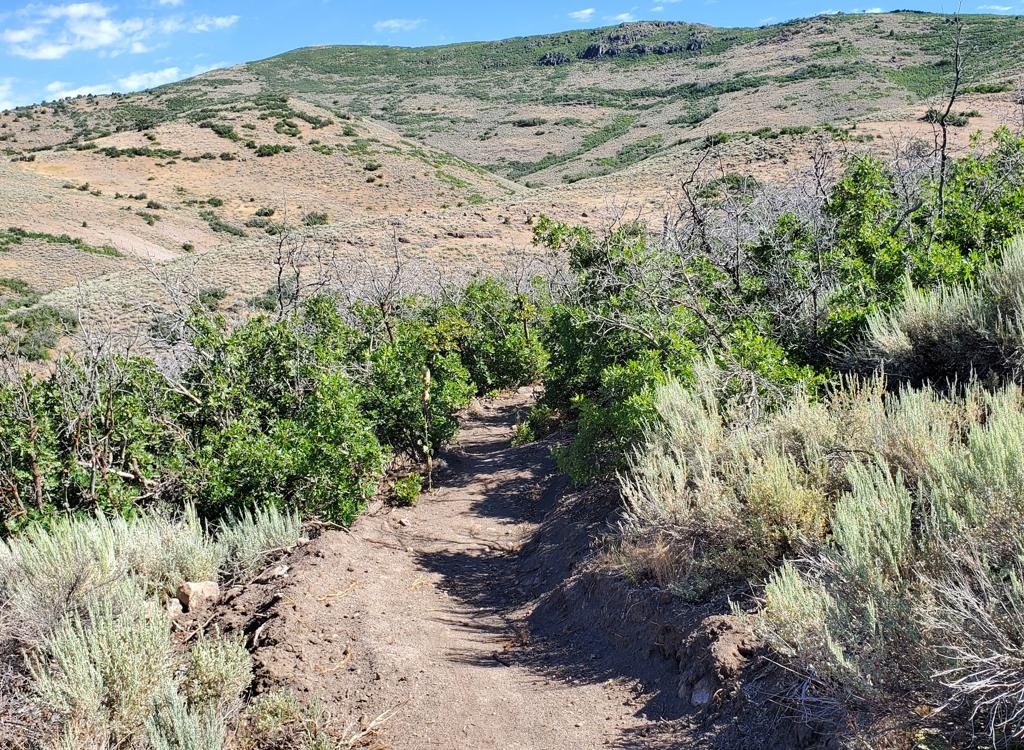
The ride starts in maple forest with occasional aspens, then heads over to a dryer hillside where the terrain is scrub oak. Photo September 25th.
Most riders will choose to shuttle this trail. It's about 5 miles by road from the lower parking
to the top, but it's not a quick drive because the road is steep and twisty.
(If you're thinking
of pedaling uphill on the road to do a loop ride, well, it's super steep.
Like 650 vertical
feet per mile steep, on a narrow road with significant weekend traffic.
But it CAN be done.)
Climbers have an option of three trailheads. In
addition to the main WOW trailhead (around 2 miles uphill from the
visitor's center), there's the
Bike Park
trailhead
and the day-use parking at the Wasatch Mountain
State Park campground.
From the day-use parking at Wasatch Mountain
State Park, the trail is across from the entry, on the east side of the
road near the self-serve fee station. Climb 0.7 miles, then fork hard
left.
The two trails ahead are
the connector from Phosphate Hill (left) and the
Pine
Canyon Flow
on the right. (The Phosphate Hill connector climbs through 20
turns. At 1.2 miles from parking, it will reach the west side of the
Phosphate
Hill loop.)
At mile 1.3 from the campground entry, you'll reach the SR
222 parking area. The trail continues across the road.

There will be views south over the golf course, Midway and Deer Creek Reservoir. Here's a view on September 9 as the maples begin to turn.

We're climbing uphill, about two miles from the bottom. This is the dryest segment of the ride -- with scrub and sage -- but it has more views.
The total climbing for an 24-mile out-and-back (from the base at the campground to the big
upper parking lot) is 2900 vertical feet -- but it's more work than you'd
expect. Allow at
least four hours. More if you're not a strong climber.
And you can add a bit of extra distance and elevation change by adding
a mile and a half of trail between WOW trailhead and the
Bike
Park trailhead
.
Most riders are starting from the SR 222 trailhead (0.7 miles up the road from the campground).
The WoW trail starts westbound across the road. Within 100 yards, you'll
arrive at the bridge
over Pine Creek. Here you'll find nature trails extending up from the
campground. Keep straight
to cross the bridge as a trail from the campground joins, then splits
away to follow the creek
uphill. At the end of the bridge, keep slightly left on the broader trail
as another nature
trail heads uphill. After another 100 yards, keep straight as another
nature trail heads 90
degrees left downhill.

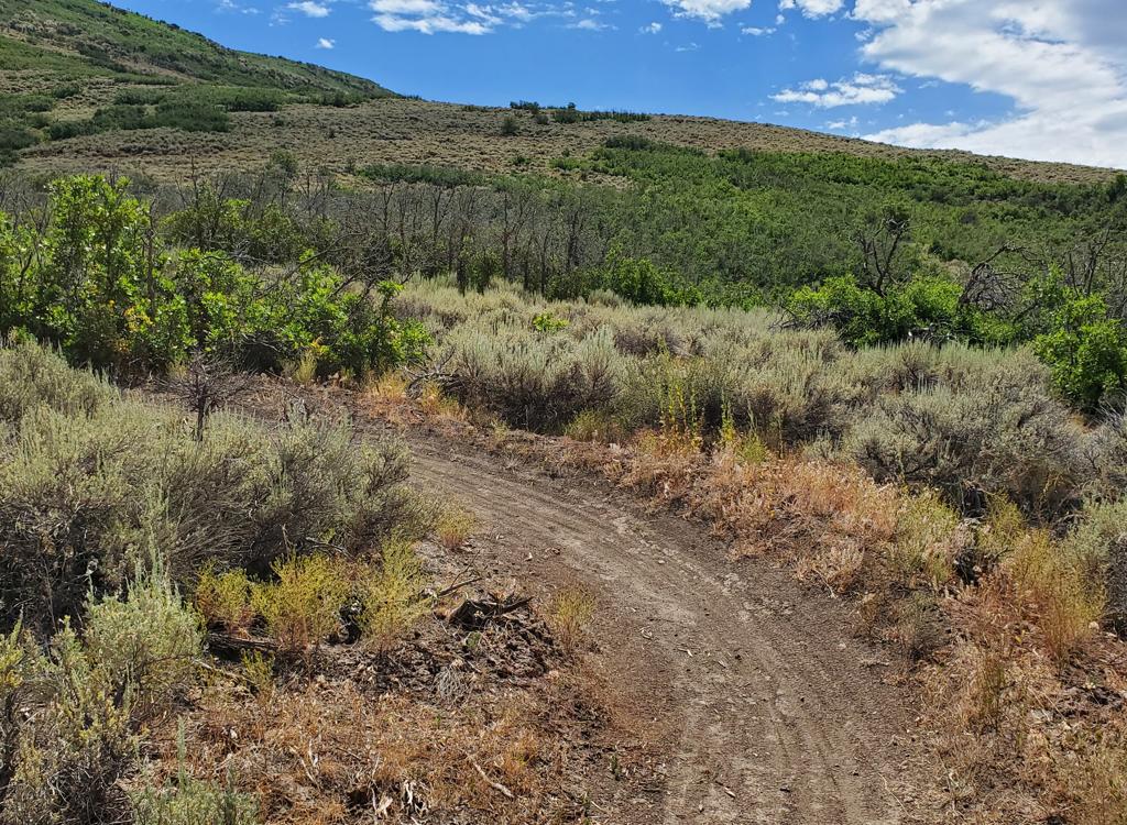
As the trail curves back around the hill in Pine Canyon (about 3 miles from the road) you'll enter deep fir forest.

You'll spot SR 222 occasionally. This road climbs up to the ridge above Deer Valley, east of Guardsman Pass. The WoW trail will eventually cross over and connect to the Deer Valley trail system.
After this first half-mile section above the road crossing, there will be another trail fork
at around mile 1.2. As you turn on an exposed ridgeline, the
Birdie Shot
trail forks away south downhill. It connects to the back of the golf course in Snake Canyon.
The first part of the trail is in maple forest. Then the trail winds around to the west to
a more sun-exposed slope of scrub oak and brush. The trail will settle
into a rhythm of long
traverse, series of climbing turns, long traverse, series of climbing
turns. You'll climb from
the dry scrub of the lower altitude to fir forest, then finally to aspen
groves in the upper
half.

View northwest at the granite ridge above Little Cottonwood.

Getting up into aspen forest, about mile 5 from the road.
The WoW trail is fairly smooth through the bottom four miles and very buff for the top four
miles. In 2015, the middle 1.5 miles is bumpy and rocky. It's very ride-able
downhill but offers
periodic challenges on the uphill.
The bottom five miles was dug first (fall 2014), and has
been improved and ridden-in. So it's pretty buff. But overall the soil
of the lower 5 miles
is much more rocky, so the riding will be rougher.
The upper four miles to SR 222 was completed by Park City's Mountain Trails in late 2015, then
a 1.5 mile extension in 2016. The higher trail has a very different character
than the lower
five miles. The upper trail is a broad undulating ribbon in smooth dirt
with broad superbly
banked turns. Although the tread was still a bit loose in fall 2015, it
has firmed up to be
an awesome section uphill and down.

A typical turn on the upper section around mile 6, with a wide turning radius and a high berm. The soil here has little rock, and the trailbuilders have taken advantage.

Climbing through aspen forest around mile 7. Just uphill, the trail descends 200 vertical feet over the next mile as it heads toward the SR 222 at Hardy Lake (mile 9).
At around mile eight uphill from the lower SR 222 crossing, the trail stops climbing and veers
east toward SR 222. It will lose 200 vertical feet as it rolls around
the ridge and drops through
a series of S turns. The pitch is gentle, so if you're dreading riding
back uphill on the out-and-back,
it's not that bad even when you're tired.
The trail passes Hardy Lake (basically a mudhole with rushes and cattails) on your right before
reaching a doubletrack. If you're finished, turn to the right and follow
doubletrack east toward
the roadside parking.

On the upper mountain, the terrain is almost exclusively aspen groves.

At 8400 feet, near the big trailhead on SR 222. Photo October 19, 2016.
To continue, join the doubletrack by veering left then immediately fork right. (Note October
2016: There's rough new trailcut on the left, just as the singletrack
approaches the doubletrack.
Until the trail extension is finished, stay on the main trail.) The singletrack
will climb
1.5 miles as the trail meanders north until it reaches the large upper
parking lot on SR 222.
Bottom Line:
Excellent climbing trail for an out-and-back, with a lot of prettiness, but reserved for riders
with a little reserve in the gas tank. As a shuttled DH (not that there's
anything wrong with
that) it's awesome.
. The tra...")
In the parking lot of the SR 222 trailhead, looking south (down canyon). The trail at the kiosk is the connector to the campground and day-use parking, with a fork to the Phosphate Hill Loop. The singletrack you want is to your right, across the road.
 if your vehicle is parked within the canyon. Self-service fee deposit stations are located throughout the canyon. Bring exact cash or a checkbook. Plus, minor detail, a pencil or pen to fill out the fee envelope and dashboard ticket.")
Map of WOW
Getting there, Pine Canyon (SR-222) trailhead: From
Provo Canyon, drive east to
the end of Deer Creek Reservoir. Right where the water ends, turn left
(north) on U-113. Zero your odometer. Drive north 3.8 miles into Midway.
On Main Street, turn left (west) onto Highway 222. Follow the signs for
Wasatch Mountain State Park and/or for Guardsman Pass, staying on 222
as below. When you pass the campground
(on your left), watch for a gravel pull-out area outlined by large
boulders on the right side of the
road about 1/4 mile later. The trail starts across the road from this
parking spot.
From Salt Lake City, go up Parleys Canyon on I-80, then turn right
(south) on US-40. Drive all the way into the middle of Heber, then at 100
South turn right on SR 113 to Midway. In Midway, continue straight as SR
113 turns south, and you'll be on SR 222. Go 2 blocks to 200
East and turn right. Turn left at 200 North and go about 1/2 mile west and
SR 222 will turn right to be northbound again. When the road turns
west, turn right to stay east of the golf course on 222. Once you pass
the campground, look for the parking area on the right about 1/4 mile
uphill.
FEE: In 2021, $10 per car ($5 seniors) if
your vehicle is parked within the canyon. Self-service fee deposit
stations are located throughout the canyon. Bring exact cash or a
checkbook. Plus, minor detail, a pencil or pen to fill out the fee
envelope and dashboard ticket.
Getting there, Campground/Day-use trailhead:
Just after SR 222 and the Pine Canyon Road join at the mouth of the
canyon, drive uphill past the golf course entry. When you reach the
campground entry (on the left), turn and go through the entry station
(paying the day-use fee rather than the camping fee), then go to the right
for the day-user parking lot. On your bike, exit the campground back to SR
222 and cross the road to the singletrack. Climb 1.3 miles uphill (keep
left as the connector from Phosphate Hill joins) to the SR 222 trailhead
and cross the road to continue.

Northbound from the campground on the WOW connector trail. Photo November 15, 2016.
 arrives at the upper park...")
Little Snowflake (my Rocky Mountain Blizzard Minus 50) arrives at the upper parking lot. Yes, that's snow on the posts. If you're starting out from here, the trail is found at the south end of the fenced parking area.
Getting there, upper 222 trailheads: If you're
shuttling, leave your pickup vehicle at one of the lower trailheads. At the
SR 222 Pine Canyon trailhead (0.7 miles uphill from the campground), zero
your odometer and drive uphill.
Shorter ride: At mile 3.4, look for
concrete barriers on the west (left) side of the road as 222 turns to the
right. There's room for 3 parallel-parked vehicles here. This is the start
for a shorter downhill. A doubletrack will take you 0.1 mile west to
intersect the trail.
Longer ride: Continue on 222 uphill to mile 4.5, then turn left and descend to the large
fenced parking area. The trail starts on the south (down-canyon) side of
the parking area, directly downhill and across the parking lot from the
entry road.
Getting there, Dutch Hollow trailhead (also a fee area):
NOTE: Riding
WoW out-and-back when starting from Dutch Hollow is long and brutal! And
yes, I've done it. From Provo Canyon, drive east to
the end of Deer Creek Reservoir. Right where the water ends, turn left
(north) on U-113. Zero your odometer. Drive north 3.8 miles into Midway,
and turn right (east) as U-113 turns right in the middle of town. 0.4
miles later (mile 4.2), turn left (north) on 400 East (River Road). This
is the road that goes just to the west of the memorial hill. At
mile 5.4 you'll hit a traffic circle. Take the first exit (not the
driveway, though), so you'll turn from north to east. At mile 6.1, a sign points you to Dutchman Hollow
- Dutch Canyon. Turn left and drive 0.5 mile on pavement. The pavement
ends at a turnaround where the Dutchman Way trail begins, GPS N 40°
32.495' W 111° 27.224'. Turn right
downhill at the sign for Wasatch Mountain State Park. The preferred
parking area is 0.3 miles down the gravel road to your right. Trailhead
info (and bathroom) is at GPS N 40° 32.704' W 111° 27.187'
From Salt Lake City, go up Parleys Canyon on I-80, then turn right
(south) on US-40. Just after descending from the dam, watch for River Road
on your right. Drive about 2 miles, turning right at the Dutch Canyon
sign. Find the trailhead as above.


 Trail")


. The tra...")

 arrives at the upper park...")