Bruce heads downhill through the aspens of the Snow Gauging trail. Original trai...
Bruce heads downhill through the aspens of the Snow Gauging trail. Original trail review June 20, 2006. Latest update August 24, 2018.
Snow Gauging Trail

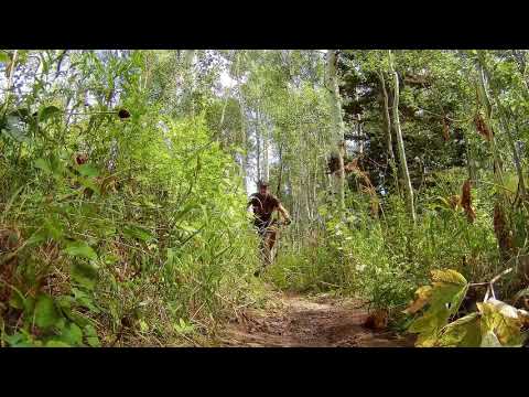
The Snow Gauging trail is 1.3 miles long, with 600 feet of elevation change. It connects the Horse Flat trail (0.5 miles above the Alpine Loop summit parking) to the Salamander Flat trail near the Alpine Loop road crossing. The trail is intermediate in skill requirement and can be ridden either direction. At this time bikers are almost exclusively doing the Snow Gauging trail as a downhill.

Ridden downhill, the trail is narrow and slightly twisty with a bit of aspen-dodging -- a very fun descent. The ride I describe below can be started either at the Salamander Flat or the Alpine Loop summit trailhead. It's a fairly short loop ride of 3.4 miles with 700 feet of climbing. The route climbs Willow Hollow and a bit of Horse Flat , descends the Snow Gauging trail, then connects back via Salamander Flat .
The trail wanders a bit back and forth to dodge the aspens.
Handlebar view of the narrow trail ahead.
The Snow Gauging trail is one of the less-used routes in American Fork Canyon. The upside of this is, there's less moto and horse traffic to widen and tear up the trail.

So the track tends to be narrow (about 12 inches). Many years I've had to hop over logs lying on the trail. There are occasional roots. So while I wouldn't call it an expert-level ride, it requires good bike-handling skills to keep your handlebars clear of the aspens and your pedals free of the vegetation at trailside.

The trail...

The Snow Gauging trail starts 1/2 mile uphill from the Alpine Loop summit trailhead on the Horse Flat trail . From the parking circle, find the trail on the western side. As you go through the log fence, the trail immediately splits into the Willow Hollow trail (straight ahead and angling downhill) and Horse Flat (a left turn uphill).

Entering the top of the Snow Gauging trail from the Horse Flat trail. To the lef...
Entering the top of the Snow Gauging trail from the Horse Flat trail. To the left is the route uphill to Horse Flat.
The trail is generally smooth, with an occasional root or bump. If motorcycles a...
The trail is generally smooth, with an occasional root or bump. If motorcycles and horsemen discover this trail, that will change.
At 0.5 miles from the summit trailhead, fork to the right. At this spot, the broad Horse Flat continues straight ahead into a bright meadow, which makes the little Snow Gauging trail harder to see as it disappears into the aspens on your right. In 2018, a nice trail marker post was installed. See photo above.
The trail quickly begins to descend through the aspens. It's not a very technical ride. The curves are generally gentle. But the aspens are never far away, so a bobble or a slide can make you kiss a tree.
Cant get enough of that twisty riding through the aspen forest.
Can't get enough of that twisty riding through the aspen forest.
For a time, the trails nature changes while in the ravine. A bit steeper, and a ...
For a time, the trail's nature changes while in the ravine. A bit steeper, and a sideslope. In the photo is a slightly more-techy section, but it's still easily done by an experienced intermediate rider.
After 1/2 mile heading northwest, the trail turns back 150 degrees into a ravine. Then it makes another tight turn through the creek (dry in late summer) to resume the northwest direction. Here it briefly enters a tall fir forest.
The trail continues a gentle rate of descent, now in a mixed forest of aspen, fir, and maple.

Watch carefully for a trail fork here at mile 1.1 of the Snow Gauging trail -- unmarked in 2018. The right fork is the official trail. (The left fork will still get you there. It circles around and joins the Salamander Flat trail just south of the Alpine Loop road crossing. This option is used by riders who are heading toward the Timpooneke trailhead. See the map.)

Heading through the aspens toward the Alpine Loop road crossing.
Were at the Salamander Flat trail. Right turn, and its 0.4 miles to the Willow H...
We're at the Salamander Flat trail. Right turn, and it's 0.4 miles to the Willow Hollow trail fork.
Assuming you noticed the trail fork and kept to the right, you'll soon cross the Alpine Loop road. 100 yards later, the Snow Gauging trail ends on Salamander Flat 150 A left turn takes you toward Timpooneke; right goes toward Salamander Flat and Pine Hollow .
Completing a loop ride...

To complete the small loop through Salamander Flat, turn right and begin a short climb.

As you begin a downslope on the ridge above Salamander Flat, 0.4 miles from where you joined Salamander Flat, fork right downhill on the Willow Hollow trail. It will drop you to the Salamander Flat parking area about 200 feet downhill. Cross the parking area to the continuing singletrack.

Cresting the ridge on Salamander Flat 150, with Timpanogos forming a dramatic ba...
Cresting the ridge on Salamander Flat 150, with Timpanogos forming a dramatic background.
Climbing the Willow Hollow trail toward the summit trailhead.
Willow Hollow climbs 1.3 miles to the Alpine Loop summit trailhead to complete your loop.

Although I've described this loop starting at the Alpine Loop summit, consider beginning at Salamander Flat. The Salamander Flat trailhead is an excellent spot to begin your loop -- beginning with the Willow Hollow climb -- because it's usually less crowded than the other trailheads. This option also puts the main climb right at the beginning of the ride.

 The Snow Gauge Loop ride from Salamander Flat...

[Back to video list ]
Riding notes, clockwise loop from summit:
0.0   At summit parking, go to west side to find trail
        N 40° 25.838 W 111° 36.869
        Immediately fork L uphill on Horse Flat trail
0.5   Fork R and begin descent on Snow Gage Trail
        N 40° 25.687 W 111° 37.105
1.6   Cross paved road, go around metal gate
        N 40° 26.110 W 111° 37.754
        Join GWT 100 yards later

2.0   Keep straight (R = Salamander Flat)
2.1   4-way, go straight across
        R = camping, L = Pine Hollow GWT
        N 40° 26.485 W 111° 37.710
2.3   Keep straight on Willow Hollow (L = Ridge Connector)
2.6   Cross road, veer R over stream onto ST
        N 40° 26.361 W 111° 37.334
3.4   At parking.
Map of the AF summit area.
Getting there:

Salamander Flat campground trailhead.  From I-15, take the Alpine-Highland exit and drive 7 miles to the mouth of American Fork Canyon. Pay your $6 fee (as of 2018) there. Five miles later at the fork in the road, go along the south fork of the river. About 4 miles up, there's a T intersection in the road. Turn left. Drive uphill past two trail crossings (Salamander Flat trail and Snow Gauging trail). 0.9 miles from the stop sign at the T, turn left on a gravel road and drive 100 yards to the parking area.
Alpine Loop summit trailhead.  From the T intersection above, continue all the way uphill to the top of the Alpine Loop. There's a parking lot on your right just before the top of the ridge. From parking, find the trail on the west side of the loop (the side that overlooks AF Canyon). Go about 10 feet down this trail, then keep straight and to the right at any sucker forks in the first 100 yards.

Bathrooms:  Summit and Salamander Flat trailheads.

Riding Resources for Horse Flat:
AF Canyon area topo map: View map
GPS track files (right-click and "Save as..."):
    Snow Gauge Loop from Salamander Flat
    GPX multi-track area file
Horse Flat ride one-page guide
Lodging, camping, shops:  Links to AF Canyon resources