The Pinecone Ridge trail opened in 2012, and it's an immediate game-changer for higher-altitude Park City riding. It creates a new and simple route from the Midmountain Trail to the southeastern end of the Wasatch Crest Trail . On this page I have information for an out-and-back, a popular Park City loop, and a loop from Mill Creek Canyon in Salt Lake.


There are frequent water-shedding swooshes that are reasonably pitched when spinning uphill. On the downhill, these add to the fun. Keep your speed in control, or you may find yourself accidentally airborne.
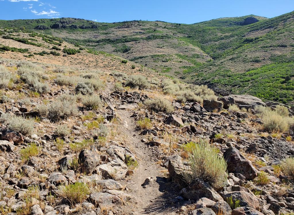
When the trail is taken downhill, sight lines are longer than almost any other Park City trail. Slow for corners and blind spots, because you'll encounter uphill riders frequently. Stop to the side for uphill riders. Most stretches of this trail don't have enough room for safe two-way traffic.If you're in a hurry, the fastest route to Pinecone Ridge is to take Spiro uphill for 2 miles, then fork right on HAM and connect to upper Armstrong.


(1) Out-and-back. Turn around and cruise back down. Take a hard right on Midmountain, then drop down Spiro to the trailhead. This ride will be about 18 miles. Many riders continue past Spiro on Midmountain and drop back to the resort on Crescent Mine Grade (CMG). This route adds a couple of miles.


This trail is an important addition to the riding options for Park City and also for the Wasatch Crest. It's technically easy and features cool forested riding followed by beautiful views. But this ride is reserved for strong, conditioned, acclimatized riders. Ending at almost 10,000 feet, that 3000 vertical is tough.
0.0 Leave PCMR parking to North
N40 39.247 W111 30.550
Cross to Three Kings Dr northbound
0.3 L uphill on Crescent N40 39.382 W111 30.813
0.4 R to gravel area, L onto ST
N40 39.401 W111 30.899
0.5 R on Armstrong N40 39.341 W111 30.900
3.7 Keep R at N40 38.898 W111 31.979
(L = HAM)
4.5 Hard L onto Midmountain
N40 39.123 W111 32.280
5.0 R uphill on Pinecone Ridge
N40 38.822 W111 32.299
9.0 Top of Puke Hill, N40 37.281 W111 33.727
Reverse direction to descend
N40 38.822 W111 32.299
14.1 L (R = Powerline), then straight to Spiro
N40 37.964 W111 32.180
(R = continuing Midmountain)
14.2 Join doubletrack downhill
14.6 L off DT onto singletrack
15.4 Keep R (L = HAM) N40 38.805 W111 31.623
4.5 Keep L on Spiro N40 38.807 W111 31.622
16.3 Keep L (R = Eagle) N40 39.163 W111 31.129
17.2 Keep L (R = Silver Spur) N40 39.306 W111 30.895
17.3 Hard R at Armstrong/Spiro junction
N40 39.341 W111 30.900
17.4 Onto pavement
17.8 Back at parking
0.0 Leave PCMR parking to North
N40 39.247 W111 30.550
Cross to Three Kings Dr northbound
0.3 L uphill on Crescent N40 39.382 W111 30.813
0.4 R to gravel area, L onto ST
N40 39.401 W111 30.899
0.5 R on Armstrong N40 39.341 W111 30.900
3.7 Keep R at N40 38.898 W111 31.979
(L = HAM)
4.5 Hard L onto Midmountain
N40 39.123 W111 32.280
5.0 R uphill on Pinecone Ridge
N40 38.822 W111 32.299
9.0 Top of Puke Hill, N40 37.281 W111 33.727
Turn left downhill on DT
9.5 Scott's Pass, L on DT
N40 36.998 W111 33.480
9.8 L onto singletrack Shadow Lake
N40 37.080 W111 33.192
10.6 Keep straight on DT
N40 37.070 W111 32.736
Straight onto Keystone
11.8 Join DT, then L on Apex
N40 37.783 W111 31.866
12.5 L on DT (Thaynes Rd)
N40 38.028 W111 31.774
12.8 Hard R on Crescent Mine Grade
N40 37.817 W111 32.020
13.7 R on Midmountain N40 38.182 W111 31.511
13.8 L on DT 100 feet, then R on CMG
N40 38.254 W111 31.441
16.1 L downhill on DT N40 38.602 W111 30.663
17.0 Back at resort (parking to left)
0.0 ST south side, middle of parking
N40 41.083 W111 38.906
1.6 Keep straight (Big Water)
N40 40.683 W111 38.486
3.4 Keep R (L = Red Pine Rd Tr)
4.6 Curve R (L = Crest Connector)
N40 41.224 W111 36.081
6.9 Keep straight (R = Mill D)
N40 39.694 W111 35.957
7.0 The Spine N40 39.633 W111 35.852
11.0 Puke Hill N40 37.281 W111 33.723
L on singletrack Pinecone Ridge
15.0 Keep L onto Midmountain
N40 38.822 W111 32.299
15.6 Keep L (R = Armstrong)
N40 39.123 W111 32.280
16.0 L onto Ironman N40 39.328 W111 32.308
17.9 L on Goldfinger (R = to MidMtn)
N40 39.543 W111 33.147
19.0 L on Midmountain N40 39.643 W111 33.355
22.1 Keep straight through Red Pine Lodge area
N40 40.675 W111 34.659
22.9 L on DT, then R on ST
N40 40.954 W111 34.720
24.7 L uphill on Crest Connector
N40 41.482 W111 35.125
26.0 R to descend Mill Creek Canyon
N40 41.224 W111 36.081
30.5 Back at parking

Parking: Not at trailhead! Use north Park City
Resort lot.
Water: None at trailhead.
Bathrooms: None.
Bike services: Multiple in Park City, includes rentals
Camping: Hailstone on US 40
Mill Creek TH: Exit eastern 215 at 39th South, turn left. Turn right on 3800 South and drive eastbound into the Canyon. Mill Creek user fee is $3 per car (as of 2009) payable as you exit. Drive all the way to the top of the canyon. The trail begins on the south end of the Big Water Trailhead parking area GPS N 40° 40.922' W 111° 38.914'. (Note: the gate to upper Mill Creek Canyon is open to cars July 1 to November 1. Mountain bikes are only allowed on upper Mill Creek trails on EVEN numbered days!)
Higher-res topo area map for printing: View map
Single-page riding guides for printing:
Out-and-back
Loop via Shadow Lake
Mill Creek Epic
GPS tracks for this ride:
GPX Pine Cone Ridge trail only
Out-and-back (Up Armstrong, down Spiro)
PC Loop (down Shadow Lake, Keystone, CMG)
Mill Creek PiCo MidMtn loop (30 miles, 4300 feet)
Park City multi-track file
Lodging, camping, shops: Links to Park City area resources