
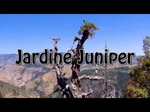

This is the Jardine Juniper, 3200 years old and still very much alive. In the background, the hills to the east lead over into the Bear Lake Valley. Initial ride review and photos August 31, 2001 by Bruce. Latest update August 7, 2018.
Jardine Juniper Trail
Why would you bike 1850 vertical feet just to look at a tree? If you have to ask the question, you aren't a mountain biker. The Jardine Juniper Trail is a nice hill climb, and worth doing just for the ride. At its end point there are great views, plus Utah's oldest tree -- the Jardine Juniper.
If you ride the circle at the end of the trail, plus the path down to the juniper, you'll cover 11.4 miles (round trip). Starting altitude is 5350 feet, with peak altitude at the end of the ridge of 7200. The ride is upper-intermediate overall, with a riding season from mid-June through October.
The trail is intermediate technical singletrack, and it's a fairly strenuous climb. The first
two miles, the trail heads straight up the bottom of the canyon, with some undulation and big
rocks to knock you around. Although not as steep (on average) as the switchback sections that
follow, this part actually seems like harder work because of loose rock, rough trail, and constant
gear-switching.

Looking up the trail on the switchback section. Although it's a 12% average grade, the trail here is smooth and non-technical. So just drop down into a comfortable gear and cruise on up.

Just getting started. The trail leaves the north end of the parking lot, across the creek from Woods Camp.
The ride starts in a sage- and grass-covered valley just across the Logan River from the Woods
Camp campground. There's a toilet at the trailhead. Temperatures here at the bottom can be
toasty warm in mid-summer. Things get significantly cooler at the end of the valley as you
hit the switchback area.
Aspen mixes with maple, fir, and juniper as you head north up the valley a couple of miles.
Then the trail turns to the southeast as you hit the hillside to begin the switchbacks up to
the top of the hill. The trail gets significantly smoother here, but you're on a steady upward
grade. Just drop into a low gear and grind on up. When you hit the Wilderness sign at mile
3.4, continue straight (right).

A meadow between aspen groves on the lower trail.

Riding past a bench on the wilderness border. Looking west at Mount Naomi.
Near the top of the ridge, at mile 4.8, you can fork left to the shady north slope for a quicker
arrival at the juniper, or you can climb further south to enjoy valley views before turning
back towards the ride's main attraction. To the juniper turn-off, it's 0.8 miles if you keep
right, 0.6 if you turn left. I suggest keeping right so you do the entire loop at the top.
If you kept straight (right) at the fork, you'll climb along the ridge, then turn back to the
north before arriving at the turnoff to the juniper. Drop down to the right. The juniper is
found 0.2 miles down some tight steep switchbacks. You can ride it on your bike, if you're
good enough. There's some deep sand on a couple of turns that may bog you down as you struggle
to climb back up.

Drone view of the top of the tree. From the end of the trail, you can walk down to this little observation deck.

View of the tree from the trail. The base is about eight feet thick. Note the twisted branch, and the small section that remains alive at the top.
The juniper has been dated at 3200 years old. This was a young tree when the Egyptians were
building pyramids.
The rocks found along the trail are mostly limestone and dolomite (also containing calcium
carbonate, but darker due to high concentration of magnesium). These were deposited during
the Ordovician and Silurian Periods (500 to 410 million years ago).

View upward from the observation deck.

Looking north, as dolomite cliffs frame the passage over the mountains to Bear Lake.
This period followed the "Cambrian Explosion" when the basic body types of all modern animals
developed, but before the deep-water deposits of the Mississippian and Pennsylvanian Periods.
At this time, plant and animal life did not yet exist on land. Because the western shoreline
of the continent ran through the Logan area, some quartzite (from sand of seashore deposits)
is found in strata from this same time.
Bottom Line!
This is one of the best intermediate-biker singletrack hill-climbs in the state. You should add the Jardine Juniper to list of "Great Rides I've Done."
This is one of the best intermediate-biker singletrack hill-climbs in the state. You should add the Jardine Juniper to list of "Great Rides I've Done."

your During out 2001 ride, Jackie pauses for a drink at the trailside, as the spring water trickles over travertine deposits onto a foot-cooling pool.

Jardine Juniper map
Getting there: In Logan, turn east on US-89 towards
Logan Canyon (about 2 miles). After you enter the canyon, drive 10 miles.
Watch for the Woods Camp Campground on your left. Cross the creek and go straight up the
gravel road to the parking area 0.1 miles later.
Camping: Woods Camp
Bathroom: at trailhead
Water: campground
Riding Resources for Jardine Juniper:
GPS track files (right-click and "Save as..."):
GPX track
Topo map: View map
Single-page riding guide
Lodging, camping, shops: Links to Logan resources
GPS track files (right-click and "Save as..."):
GPX track
Topo map: View map
Single-page riding guide
Lodging, camping, shops: Links to Logan resources
Updated 2018


