The trail climbs ridges of Kayenta sandstone beneath towers of Navajo. Photos and trail review by Bruce on March 16, 2014.
Hymasa TrailThe Hymasa Trail is a 3.2-mile singletrack trail in the
Amasa
Back riding area
. It's a two-way trail great for both climbing and
descent. The singletrack begins where the
Amasa
Back trail
leaves Kane Springs Canyon Road. It extends up to the
saddle on the mesa. It's upper-intermediate in technical requirement and
moderately strenuous.
There's one gap in the singletrack: Hymasa joins the main Amasa Back trail just before crossing
Kane Springs Creek then diverges again uphill. Hymasa gives cyclists a fun and easier alternative
to climbing the brutal ledge-filled Amasa Back jeep route.

Having finished his fun on Amasa, a rider approaches the end of Hymasa.

View east as the singletrack leaves the main Amasa jeep route.
Hymasa begins where the jeep route plunges off Kane Springs Canyon Road, 0.5 miles uphill from
the Amasa parking area. As you turn to the right to drop downhill, the singletrack is immediately
to your left. There will be 1/3 mile of singletrack before it rejoins the main Amasa Back route
(keep left and downhill as you join the main path).
One-quarter mile after plunging through the creek, you'll see the downhill end of Captain Ahab
on your left. Keep to the right and continue climbing on the broad main trail. At mile 1.3
from the parking lot (0.2 miles uphill from Captain Ahab), fork uphill to your right on the
Hymasa singletrack.

Looking west as we climb around skirts of Kayenta sandstone.

View east toward the mouth of Kane Springs Canyon. The towers are Navajo sandstone.
The trail clings to the hillside just above the Amasa Back trail for 1/4 mile, then crosses
to the downhill side at mile 1.5 from parking. At mile 1.8, you're back to the main Amasa Back
jeep route for another crossing.
Head uphill across Amasa to the singletrack on the north side. The trail will take you up to
the top of the next little ridge, where Hymasa turns back west.

Climbing westbound. Most of the trail is fairly straightforward intermediate riding.

Occasional blue paint stripes mark the path on sandstone. There will be occasional ledges, but nothing scary. An experienced upper-intermediate can clean everything on the first try.
At mile 2.4, you'll approach the Amasa Back trail from the uphill side. Continue across to
the south side. You've now crossed Amasa Back for the final time. The trail will meander generally
south and west.
3.1 miles from the parking lot, you'll temporarily join the Ahab midpoint trail. (This trail
connects the midpoint of Captain Ahab to the Amasa Back main trail.) Captain Ahab is to your
left if you're looking for a shorter (but expert-level technical) ride. To keep climbing uphill,
fork to your right on the combined midpoint-Hymasa trail.

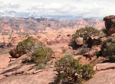
As we climb higher, we're seeing the La Sal Mountains above the domes of Navajo sandstone across Kane Springs Canyon.

100 feet down the trail, we're about to cross the main Amasa Back trail for the last time.
After about 100 yards, the trail splits. Keep left on Hymasa. (The right fork takes you to
the main Amasa Back trail.) Hymasa will now wander west-northwest toward the Amasa saddle.
At mile 3.7, Hymasa ends on the
Captain
Ahab
singletrack. Intermediate riders (and those planning to join the main Amasa Back route) should
fork to the right and proceed to Amasa on the saddle 0.1 miles to the east. From here, north
takes you on
Amasa
to the viewpoint, or to
Pothole Arch
,
Rockstacker
, or
Jackson Singletrack
.

Near the trail's end on Captain Ahab, a rider descends Hymasa.

Looking north at the cliff-line of Amasa Back, with Jackson Hole in the center. At the left edge is the rincon, called Jackson Not-Hole. The viewpoint at the end of Amasa is on the skyline at the left.
Enjoy the views from the saddle. To your north is Jackson Not-Hole, a rincon left behind when
the Colorado River cut through a meander. The cliffs are Wingate sandstone. The cap-rock of
the Not-Hole (and the layer you're standing on) is Kayenta.
To the west, dark Moenkopi mudstone rises in layers from the Colorado. Between the Wingate
Cliffs and the Moenkopi are the lighter bands of the Chinle Formation. These formations are
from the Triassic Period.

View west at the banded layers of mudstone above the Colorado River.

We're actually on Captain Ahab for this view to the east. The La Sal Mountains form the skyline.
To the east are the La Sal Mountains. The domes of light rock between you and the mountains
are Navajo sandstone from the early Jurassic Period, about 200 million years ago.
OK, break time is over.
Now, where are you going to ride?North on Amasa can take you to the viewpoint. This is an upper-intermediate option. From there,
you can head to Pothole Arch, or not.
Tired bikers can coast back downhill on Hymasa, or tackle the ledges of the main Amasa Trail
downhill.

A rider cranks up one of the smoother spots on Captain Ahab.

Many of the steep descents on Ahab are paved with stonework ramps.
My featured ride below makes a lariat loop by riding Captain Ahab.Do not underestimate Captain Ahab. The challenges are unrelenting, requiring excellent handling
skills, strong legs, and an aggressive attitude. This "short loop" will be 9.2 miles with 1600
vertical feet of climbing.
You'll do twice as much work "descending" Ahab as you did climbing to the saddle on Hymasa.
There will be about 800 additional feet of climbing, much of it out-of-the-saddle as you attack
the endless small mounds of sandstone.

Riders attack the rolling sandstone on the upper half of Captain Ahab.

A young lady descends the ledges with finesse on lower Ahab.
Shortly before you reach the Ahab midpoint, the riding gets easier and you can finally open
it up and cruise. But technical challenges still await.
When you see the sign that says Get Off Your Bike, do it. You're approaching a couple of at-an-angle
ledge drops just before a turn at the top of a certain-death cliff.
Ahab rejoins Amasa about a mile from parking. As you climb away from the creek-crossing, be
sure to catch Hymasa on your right.

Almost done as we cruise east on Ahab. The Amasa trail is on the ridge above us.
Ride notes, Hymasa to Ahab loop, 9.2 miles
0.0 Right uphill from parking
N38 31.695 W109 35.805
0.5 Drop R 15 feet, then left to ST Hymasa
N38 31.445 W109 36.101
0.8 Keep L to merge with main Amasa
N38 31.525 W109 36.063
0.9 Cross creek N38 31.588 W109 36.075
1.1 Keep R on Amasa (L = Ahab end)
N38 31.523 W109 36.261
1.3 R on singletrack Hymasa
N38 31.560 W109 36.336
1.5 Cross Amasa from uphill
N38 31.456 W109 36.338
1.8 Cross Amasa from downhill
N38 31.329 W109 36.490
2.4 Cross Amasa from uphill
N38 31.330 W109 36.490
3.1 R to join midpoint trail
N38 30.869 W109 36.622
3.2 L off midpoint on Hymasa
N38 30.875 W109 36.671
3.7 L on Captain Ahab
N38 31.084 W109 37.156
(option: R 0.1 mile to Amasa saddle)
6.1 Keep straight (cross midpoint trail)
N38 30.809 W109 36.594
8.1 R downhill on main Amasa
8.3 Cross creek
8.4 R uphill to Hymasa N38 31.525 W109 36.063
8.7 Exit ST, R uphill to road, L downhill
9.2 Back at parking

Hymasa singletrack trail segments are shown in black.
Getting there: Head south on Moab's Main
Street. When you reach the McDonald's on your right, turn right onto Kane
Creek Blvd. After 0.6 miles, go straight where the road seems to turn
right (500 West). Drive along the Colorado River about 5 miles until the
road turns to gravel, and head uphill about 2/3 mile. Watch for the "Amasa
Back Parking" area at GPS N 38° 31.329' W 109° 35.501'. Park here.
Pedal further up the gravel road 1/2 mile, and turn right onto the trail
at the sign.