

Nung'wu Poa
(Paiute Trail)
Nung'wa Poa is a trail system on the southern edge of Springdale. The first section of trail was opened in October 2021, with phase two coming in fall 2023. I'd give the ride an upper-intermediate rating because of the steep loose climb required to reach it and the bumpy trail surface. With a few short hikes, Nung'wa Poa can be done by a strong early-intermediate rider.
At this time (2023) there are no trail signs, and no on-line navigation aids. So come prepared to find your own way through the system!
The Paiute Trail has several sections and loops, and I don't know if there will be individual names for these sections. So I've randomly selected names that correspond to their location.
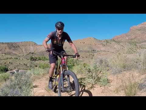
Nung'wa Poa lies at around 4000 feet elevation just outside Zion National Park, up a steep side-slope from the river bottoms in Springdale. Nung'wa Poa -- which translates to "Paiute Trail" -- is on Paiute Tribe land. The area will receive snow in the winter, so the expected riding season would be March through December.

Trailhead and connections

To reach the trail, park at the first lot along Highway 9 in western Springdale. Parking in Springdale requires credit card payment, available at kiosks along Highway 9. Then pedal the paved bike path to George Barker River Park, about a mile to the east. In the park, take the sidewalk to the footbridge over the Virgin River.
Note that the few parking spaces within River Park itself are restricted to those currently using the park -- picnics, etc. Visiting families would appreciate it if you not park here merely to pedal away.
Riding Paiute Trail as a loop

A loop ride from the park -- going up via one of two climbing trails, then through the trail system -- will be 3.0 miles with around 500 feet of overall climbing. See the track file.
A climb via the doubletrack is brutal but short, and the climb via the southwestern singletrack has some steep loose spots and a couple of tight turns. So it's not much easier.
For my ride in 2023, I went southwest from the trailhead, climbing up the singletrack. At the loop fork at the top, keep right at mile 0.5. At mile 1.0, the trail turns away from a canyon that's on your right. There's a faint singletrack here that follows the edge. Instead turn to the left.
At mile 1.1 you're at the opposite side of the mesa, where you'll turn right at the trail fork.


At mile 1.6 you'll join the middle loop. Keep straight and curve around the small hill. The riding now gets more technical, because you're on older hand-built trail. When you hit the other side of the loop at 1.7 keep to the left and find yourself on an old doubletrack heading uphill.
At mile 1.8, fork to the left on singletrack. Climb up the hill and descend through turns on the eastern loop. The eastern loop is hand-built and is the most technical of all the trail sections.
At mile 2.7 you're back at doubletrack near the entry to the middle loop. Turn to the right downhill and drop back to the trailhead for a three-mile ride.

Trail Sections - the river bottoms

Immediately across the bridge is the Mary Bonner Nature Trail. The nature trail has a 1/2 mile loop plus out-and-back trails running parallel to the Virgin River at each end. I saw no indication that the loop is restricted to foot traffic, and there were bike tracks. But evaluate the number of strolling tourists on the trail before you decide to ride around the loop.
Trail Sections - Doubletrack climb

The nature trail forms a small loop south of the Virgin River (see map), with one corner at the foot bridge. As you cross the bridge, keep straight and head away from the river toward the sage-covered hill.
After about 50 yards, you'll come to a trail fork. Keep to the right to exit the nature loop, aiming for the metal gate on the edge of the hill. Go around the gate at mile 0.1 from the bridge and begin climbing.
The climb up the doubletrack is stiff, gaining 150 vertical feet in 1/4 mile. I found the traction to be OK -- three days after a heavy rainstorm -- but at times there will be loose rock and churn. Many riders will need to walk their bikes here.
At around mile 0.4 from River Park, look carefully for singletrack forking away to your left. In 2023 it's not obvious at all. This is the northern (downhill) side of the eastern loop of Nung'wa Poa.

If you continue uphill on the DT, about 50 feet uphill the middle loop forks away to the right. If you continue straight, you'll reach the upper entry to the eastern loop (on your left) in another 0.1 miles.
If you continue straight on the steep doubletrack, it will become singletrack along the edge of a canyon to the south. It will join southern side of the main route (as I describe it) at mile 0.6 from the gate in the river bottoms.
Trail Sections - Eastern Loop

The lower (north) entry to the eastern singletrack loop is found at mile 0.4 from the trailhead via the doubletrack. If you're arriving from the middle loop, turn to the left onto the doubletrack, then find the singletrack across the DT about 30 to 50 feet downhill.
The upper entry (for a counterclockwise loop) is found further uphill on the doubletrack. Pass a couple of connectors on the left, go above the water tank, then veer to the left as the trail peals away from the old doubletrack.
The eastern loop has great views of the Zion area as it meanders back and forth. When done clockwise, it will gradually gain elevation. At mile 0.8 of the loop, you'll arrive back at the doubletrack just uphill from the starting spot.
In 2023, the route definitely needs more bike tires, and some work to make the route stand out. The entry to the loop was a bit hard to see if you don't already know it's there. My guess is that many bikers are simply riding past it.


Once you're back at the doubletrack, find the entry to the middle loop. It's just a little uphill and across the doubletrack from the lower eastern loop entry. The singletrack will quickly split into a loop. You can go either direction.
(On the opposite side of this small loop is the northern ridgeline trail, which will take you west for a continued ride and a clockwise loop.)
Trail Sections - Middle Loop
The middle loop is just 1/4 mile around. On the eastern side, the loop fork is just a few feet from the climbing doubletrack. On the western side, the ridgeline trail forks away.
If you're riding east to west, I'd suggest you turn right as you enter the loop. Hook around the hill once -- just for fun -- by keeping to the left at trail forks. Then turn to the right when you hit the fork for the ridgeline trail.

Trail Sections - Western singletrack climb

To reach the loop from the west, head southwest on the river bottom trail until you see the singletrack forking away to your left to climb the steep hillside at mile 0.2. Drop into climbing gear and grunt uphill.
At mile 0.5 from the trailhead, you'll arrive at a trail fork. Keep right. (Left is a steeper, less-fun short-cut route along the edge of the mesa. It rejoins the main trail just uphill.)
Trail Sections - Southwestern Loop

You can ride the southwest corner of the trail system as a loop. If you keep to the right (heading southwest) at the trail fork above, you'll curve around to the southern edge of the mesa. At the southeast tip of this small loop, keep left as the (faint) singletrack along the south edge forks away. The trail will then return to the northern side.
Here you'll reach T trail fork. Left takes you back to the fork above the climbing trail, while right takes you along the ridgeline eastbound. Turn to the left and downhill to make a lap around the southwestern loop.


Because this section is machine-cut, it's the smoothest and easiest part of the trail system. Even beginners will enjoy this bit of trail, once they get up the hill from the river bottom area.
Trail Sections - Ridgelines Loop

You can make a loop of the less-traveled trail along the southern edge of the mesa by taking the doubletrack all the way uphill, then following the singletrack to the southwestern loop.
After riding around this loop, you can follow the northern edge of the mesa back to the middle loop, and from there back to the doubletrack.
Bottom Line!
This trail system has great views of the cliffs around Springdale and the entrance to Zion National Park. With the addition of the Phase 2 trails, it's now a worthwhile destination. In 2023, the eastern loop needs more riders, and should have some attention paid to establishing an obvious riding line in the transition areas where one trail section meets another. Trail signs would be a bonus!

Getting there:
Take Highway 9 to Springdale. As soon as you enter town, look for a parking strip on the right side of the road. (All parking in Springdale requires a fee, which can be paid at a kiosk with credit card.) Start your ride on the paved bike path eastbound along the road. Go around a mile east before turning right into George Barker River Park. Get onto the sidewalk and head for the foot bridge at the southern side of the park along the river.
The parking spots in River Park are reserved for those actually using the park. If your family will have a picnic while you ride, fine. Otherwise, park elsewhere (paying your parking fee) and pedal the paved path along Highway 9 to the park.
Resources:
Download area tracks
Lodging, camping, shops:
Links to St.
George area resources


