View of a tiny falls near the trail crossing of Racetrack Creek. Photos and ride September 16, 2009 by Bruce and Jackie.
Willow Creek 025 South
French Hollow and optional Buffalo CanyonThis ride is located in the high ridge country between Strawberry Reservoir and Spanish Fork
Canyon. It is NOT the cushy Willow Creek 001 found north of Strawberry
near Daniel's Canyon
summit. This Willow Creek trail is best classified as an "adventure ride"
-- definitely reserved
for very experienced riders who come well-prepared.
Important notice for riders with
maps!
Do not, do not, do not follow the lower Willow Creek trail
route shown on your topo map or software. Every source I checked showed
a
nice trail extending all the way down Willow Creek to the Strawberry
River, then turning upriver and connecting to the road below the dam.
It
looked very tempting; an awesome loop ride. Well, that trail does not
exist any more. Stick with my suggestions and it's unlikely you'll die
in
the wilderness. Which is a distinct possibility if you try to get all
the
way down the Willow Creek gorge to the Strawberry River.
In the year of my ride, the Willow Creek trail hadn't seen a lot of use. It's a legal route
for motorcycles, and the trail desperately needed a herd of them to establish
a clear riding
route. The trail was hard to find and sometimes hard to follow. While
the trail never strays
far from the willows along the creek, the frequent game trails and alternate
tracks will have
you following a few dead ends.

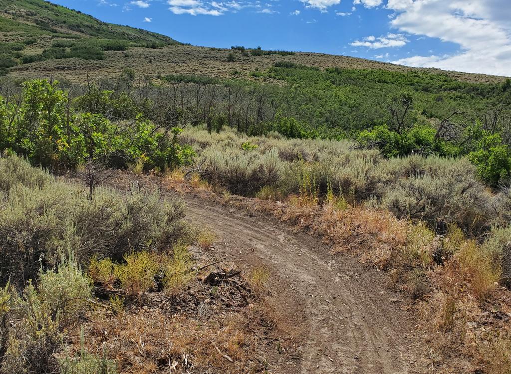
This is FR 090 as we climb up on the Epic ride. The first few miles of 090 is suitable for family cars in all weather, but after storms there may be mud in some areas further on. If you're uncertain about road conditions, drive FR 131 from Strawberry's west side and park at the FR131 - FR 090 junction.

View from FR 090 of Soldier Creek, as the wind whips the surface into shimmering blotches of color. On the skyline to the left, those are the sharp peaks of the Uintah Mountains. The road ride portion of the Epic is actually a beautiful and fun experience.
You need maps, a good ride description, and an accurate odometer or GPS unit loaded with the
ride's track and coordinates. Come prepared and give yourself plenty of
time. The scenery is
beautiful, and the riding in the gorge offers its own brand of fun.
The lower portion of the trail is not only hard to follow, it suffers from grown-in brush.
Not just sage, but currant and rosebush that will razor your legs. I suggest
you bring shin-guards
or long cycling tights and put them on when you hit the area between Buffalo
Canyon and French
Hollow.

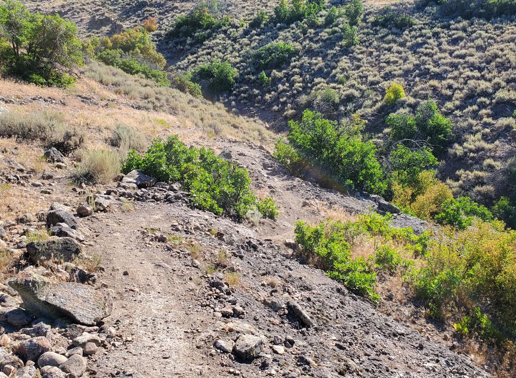
Top of the French Hollow Trail on FR 090. If you're dropping down here (or climbing up), the top 1/4 mile is moderately steep, but not that tough.
 View to the west and northwest with Cascade Mountain, Mount
Timpanogos, then Lone Peak and the Cottonwood Canyons.
View to the west and northwest with Cascade Mountain, Mount
Timpanogos, then Lone Peak and the Cottonwood Canyons.

As we reach the southern end of the road ride on FR 131, we're looking into Spanish Fork Canyon (mid-right in the photo is a US-6 highway road-cut).
Many sections of the Willow Creek trail traverse steep slopes, with a very narrow riding line.
While fat knobbies help, the most important factors are skill, speed,
and confidence. These
steep slopes are prone to washouts, which adds to the challenge. I liked
it, but not many riders
will.
There are probably two places beyond French Hollow where a route takes you left up to FR 090.
But I haven't confirmed that the top and bottom actually connect. Let
me know if you've explored
these options. Now a disclaimer: I did not actually complete any of the
rides listed below.
I did a few pieces of the top and bottom of the connector trails (Racetrack,
Buffalo, Center,
French) just to prove they were there. But I was suckered by existing
maps into riding further
down Willow Creek into impenetrable jungle.
Already over 32 miles into the ride and too late in the day to turn back, I thought good trail
was just around the next bend. So I dragged and carried my bike through
brambles and over huge
boulders in the creekbed. For two hours. I'll save you from that. Don't
go past the fence.

We're finally at the Willow Creek Trail. After hiking through a few campers and trailers that were parked right on the trail, I found this trail about 100 yards from the road.
I'll offer 4 loop options:
Climber's Epic: 36.2 miles w 4300 vertical. Base 7500, top 9500.
The Big Loop: 21.6 miles w 2400 vertical. Low 8000, top 9500
French Buffalo: 13.6 miles w 1600 vertical. Low 8000, top 9500
Racing Buffalo: 7.1 miles w 500 vertical. Low 8200, top 8600
Climber's Epic:
36.2 miles w 4300 vertical
Drive to the east end of Soldier Creek, head toward the dam, then pass
Aspen Grove campground and marina. Park at the alternate Strawberry
Narrows trailhead 0.3 miles uphill, just off the paved road. Climb and
descend FR 090 then turn left on FR 131.

The trail follow the creek down a very slightly sloping canyon. You can see a sliver of the trail at the far right of this photo.
When FR 131 splits at mile 18.5
(Reservation Ridge on L and 131 to Soldier Summit on the R), find the
trail on your left at the north end of the clearing. Blunder your way to the
French Hollow trail 7.9 miles later, then climb 2.5 miles up French
Hollow. Turn right and ride 7.3 miles on FR 090, climbing up over the
ridge again and back to your car.

A bit further on, this 8-inch ribbon on the side-slope is the trail. Not too bad here -- you can motor right along. But it's not for the unskilled.
The Big Loop:
21.6 miles w 2400 vertical
This is the option that most experienced and adventurous riders will go
for. Go around the west end of Strawberry, passing the Renegade Point marina on
FR 131. When FR 090 comes in on your right, park there and begin riding
south on 131. Ride 7 miles to the Reservation Ridge - 131 split (see the
navigation information below -- there are a lot of forks in the road).
Head
north on the Willow Creek trail. At the French Hollow trail 7.9 miles
later, climb 2.5 miles up French Hollow. Turn left on FR 090 and ride 4.2
miles back to the car.
French Buffalo:
13.6 miles w 1600 vertical
This will likely be the favorite. Fun creek crossings, enough riding to
satisfy. This loop circles through French Hollow and Buffalo Canyon, and
can be ridden either way. (The top of French Hollow is a little steeper, if
that makes a difference to you.)

OK, now we're talking tricky. This can be ridden, but you've got to keep up your speed and keep your line smooth.

Just thought you'd want to know: trail. This was the only trail marker on Willow Creek. The tiny brown stripe left of the bike is the trail.
Drive to the top of French Hollow. Drop 2.5 miles down French Hollow, then fork R (south) and
ride slightly uphill 3.2 miles to Buffalo Canyon. Climb Buffalo 2.5 miles
to FR 131 and turn
R. 1.2 miles later, turn R again on FR 090 and climb back up to your car.
Or do it the opposite
way.
Racing Buffalo:
7.1 miles w 500 vertical
This is the easiest option, although the trail isn't very easy to follow
in the bottom of Willow Creek. Drive to the top of Buffalo Canyon on FR
131. Ride 131 for 1.4 miles to the Willow Creek guardstation road and turn
left.

A shallow creek, fun to splash through, as Jackie follows the bike up the other side.

Then there's this crossing, with hip-deep water and a muddy bottom. Jackie got to practice her swimming skills. She hates swimming. The bike wouldn't touch bottom because it was floating.
Just before the guard station, turn right (south) across the meadow, then turn back east again
and follow the DT until it becomes the ST Racetrack Canyon trail. After
2.0 miles from 131,
fork left along Willow Creek and ride 1.4 miles to Buffalo Canyon. Fork
left up the canyon
and ride 2.5 miles to your car. Then there's this crossing, with hip-deep
water and a muddy
bottom. Jackie got to practice her swimming skills. She hates swimming.
The bike wouldn't touch
bottom because it was floating.
So is this ride worth doing? Yes.
Less-strong riders can do the loop using Racetrack Creek and Buffalo Canyon. There's little
climbing, and you can hoof it through the areas along Willow Creek that
are hard to ride or
confusing. For the easy ride, just remember, whichever direction you ride,
when you hit the
next canyon, turn. And always turn the same direction.

As we get lower still, the trail features currant bushes, roses and other harsher shrubs to scratch you as you ride. It's pretty, though.

Looking back up the canyon. Can you spot the trail, an eight-inch ribbon of dirt hidden in the shrubs? Amazingly, I could actually motor through here pretty efficiently.
Adventuresome riders will enjoy the side-slope hugging runs along the ravine above the willows
as you crank downhill on the epic ride. If enough motorcycles and bicycles
hit this canyon,
it won't be confusing (or as difficult) any more.
The creek-splashes between Buffalo Canyon and French Hollow are a hoot. Plan to get wet.
Did I mention the scratchy shrubbery? It's all part of the adventure, but if you don't want
your legs scratched, bring riding tights or shin guards.
And if you ride the trail, tell the forest service that you'd like to see them (1) create a
single, non-confusing trail alignment, (2) put in more signs, (3) change
their maps so people
aren't arriving at the dead end, and ideally, (4) create a tie-in to the
lower trail, running
over to Soldier Creek so we'll have a great epic riding loop.

The front of my legs at the sockline.
Road riding notes for Climber's Epic:
0.0 Park at pullout on R side of road, 1/3 mile past the
marina
N40 07.851 W111 02.316
Ride uphill (R) on pavement,
which becomes gravel
2.0 Keep straight (R) N40 06.492 W111 02.698
2.5 Forest border
3.8 DT on R, trail on L, keep on road
N40 05.818 W111 04.034
5.0 Temporary reprieve from climbing, Alt 9200
6.3 Trail 360 forks off on L, keep straight
N40 04.763 W111 06.032
6.5 Keep straight and L, DT on R
N40 04.789 W111 06.152
7.4 Straight. DT 109 on R, top of French Hollow on L
N40 04.628 W111 06.935 Alt
9000
8.3 Keep L, R = FR 679) N40 04.003 W111 07.018
9.1 Viewpoint Alt 9500
9.4 Keep straight, R = Center
Canyon
N40 03.637 W111 07.875
11.5 L on FR 131 N40 03.065 W111 09.500
12.3 L toward White River on 131
N40 02.643 W111 09.390
12.8 Keep straight, R = Buffalo Canyon
N40 02.426 W111 09.112
13.9 Straight. R = Guard Station and Racetrack Creek
N40 01.579 W111 09.202
14.8 Fork L toward Soldier Summit (continue 131)
N40 01.277 W111 10.023
16.0 Keep on road (DT to Willow Creek on L)
N40 00.389 W111 10.155
18.5 Arrive fork FR 131 (Soldier Summit and Left Fork) and
Reservation Ridge road. Find
trail in meadow on L.
N39 59.196 W111 09.232
Riding notes, Willow Creek downhill from top:
0.0 At fork FR 131 (Soldier Summit and Left Fork) and
Reservation Ridge road. Find
trail in meadow on L.
N39 59.196 W111 09.232
2.0 Cross to west (L) side of creek, cross feeder creek
N40 00.422 W111 07.894
Faint trail joins from canyon
on L
3.3 On L side of creek, cross Racetrack creek
Trail joins, keep R, N40 01.148
W111 07.190
4.0 Confusing area, find your
way. Suggest L side.
4.7 Veer L into Buffalo Canyon, cross creek
Trail joins, hard R, N40 01.907
W111 06.577
6.8 On R side of creek, cross Center Canyon trail
N40 03.087 W111 05.049
7.9 French Hollow crosses at angle,
N40 03.849 W111 04.496
Hard L to climb French Hollow
10.4 Top of French Hollow at FR 090
Getting there, FR 090 (Soldier Creek) for Epic Ride or
driving to French Hollow: On
US 40, go eastbound up Daniel's Canyon and cross the summit. Continue on
US 40 past Strawberry Reservoir. Pass the Soldier Creek campground, then
1/2 mile later turn right toward Soldier Creek Dam (road fork is N40 10.960 W111
01.690). After 3.3 miles, keep R at the fork and continue toward the dam
and marina. At 4 miles from US 40, turn R and go across the dam. At 5.2
miles, you reach the intersection for the Aspen Grove campground (left)
and the marina (right). Continue on another 8 miles if you're headed for
French Hollow (ignore the big no-trespassing sign; you're on a public
road). To do the epic ride, drive 0.3 miles past the marina. Just after the road turns to the left, exit on dirt
doubletrack N40 07.851 W111 02.316. Park there. Start your ride by heading
up the hill on the paved road.
Getting there, FR 131 (from Strawberry): On US 40, go
eastbound up Daniel's Canyon and cross the summit. 4.7 miles after the
summit, turn R on the main Strawberry road. Continue south toward Indian
Creek at the far southeast corner of the reservoir. Drive past the
Renegade Point marina and and continue southeast on FR 131 and begin
climbing. About 6 miles past Renegade Point, FR 090 comes in on your left
at N40 03.065 W111 09.500. Park here for the big loop ride, or turn left
on 090 if you're headed to the top of French Hollow. For Buffalo Canyon,
keep straight. Note the directions and coordinates above to navigate your
way to the Buffalo Canyon trailhead.


 View to the west and northwest with Cascade Mountain, Mount
Timpanogos, then Lone Peak and the Cottonwood Canyons.
View to the west and northwest with Cascade Mountain, Mount
Timpanogos, then Lone Peak and the Cottonwood Canyons.