

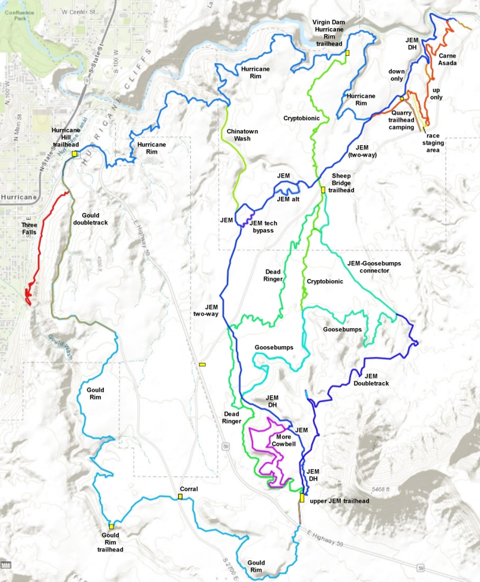
The More Cowbell trail creates one of the few beginner-level singletrack rides in the Hurricane area . So it deserves its own page. The More Cowbell trail is 2.5 miles in length, but you'll have to take JEM or Dead Ringer to get to it.
The trail is open year round, but lies on clay that can be damaged if ridden while wet. If there have been recent storms, check conditions with the local bike shop before going.When deciding about young children, realize there are cliffs nearby plus a couple of short sections where the trail sits on side-slope. The trailbuilders want More Cowbell to remain narrow singletrack, and trailers mess that up. (The JEM Doubletrack going northeast along the mesa from the upper JEM trailhead is actually a nice ride and is recommended for trailers and side-by-side riding.)


In Hurricane, turn south on US-59 (towards the Grand Canyon). Drive exactly 5 miles uphill. Turn left on cindered doubletrack right as you approach the base of Gooseberry Mesa. Drive another 0.3 miles to the parking area. Cross the cattle guard at the gate, then immediately turn left downhill on singletrack. At the trail fork around 1/2 mile later, go left again for a clockwise loop or fork right for the counterclockwise ride.

This trailhead with bathroom and bike stand is found
half-way along the gravel Sheep Bridge Road, which connects US-9 to US-59. Drive toward
the upper JEM trailhead on Highway 59 as above. But at mile 3.3 (while
still on the flat area), turn left on gravel Sheep Bridge road. Drive 2.9 miles on Sheep Bridge
road to a fenced parking area with a bathroom. Cryptobionic and
northern Dead Ringer can be found here.
Option, roadside
parking off US-59: If you turned onto Sheep Bridge Road from Highway
59, immediately park on the
right, just inside the fence. Pedal 0.4 miles northeast to where the JEM
singletrack crosses.

From Highway 9 in Virgin, turn south onto Sheep Bridge Road. Drive 1.7 miles. As the gravel road drops into a dip, there are two paths on your right. The ridgeline road is the race staging area. There's a connector to Carne Asada in about 100 feet on your right. The second dirt road, around 50 feet downhill, is the primitive camping and trailhead area. JEM crosses this road at the bottom of the camping zone, and Carne Asada is found to your right on JEM downhill from the road.

This trailhead serves the Hurricane
Rim and Gould's trails. Other trails in the system are reached via these
trails. In Hurricane, turn south on US-59 (towards the Grand Canyon).
Follow the road uphill 0.9 miles, then turn left into the trailhead
parking near the cell phone towers. The dirt road 0.2 miles back down U-59
is the trail's start.
Option, Gould's Wash corral: As you head uphill on Highway 59, pass
gravel Sheep Bridge road on your left (about half-way between Hurricane
Hill and the JEM trailhead). Now watch for a dirt road on your right. It
will take you to the corral. If you're heading for the rim, go directly
west from the corral for 1/2 mile.
, just 100 feet from the trailhead at the end of the doubletrack.")
In La Verkin, turn east onto Highway 9 toward Zion National Park. Drive 4 miles uphill. Just after you reach the first homes approaching Virgin, find the cindered Sheep Bridge Road on your right. Descend toward the bridge across the Virgin River and find a parking spot along the road. Start pedaling. Just past the bridge, but before the cattle guard, there's a dirt road to the right. This will take you to the bottom of JEM and Carne Asada. (The parking directly at the bottom of JEM is reserved for the nature conservancy.)

Coast gently downhill as the singletrack meanders 0.4 miles north. At the trail fork, go to the right on More Cowbell for a counter-clockwise ride. You are now on the loop portion of White Ledges. The left fork will be your return path (and also connects to other riding options).


More advanced riders: As you reach the doubletrack at the top, go straight across onto JEM. Take JEM downhill, passing through the Goosebumps intersection. Just before Sheep Bridge Road, turn left on Dead Ringer and climb the back to the top. Do More Cowbell clockwise on your way up. Great riding!
The upper portion of JEM (from the Highway 59 trailhead down to the Goosebumps intersection) is now one-way, downhill only. When climbing to the Highway 59 trailhead, you must use either Dead Ringer on the west or the JEM Doubletrack from the east.

0.0 Upper JEM TH, cross cattleguard
Immediate left on ST downhill
N37 08.358 W113 14.515
0.4 Keep R for counterclockwise loop
N37 08.481 W113 14.632
N37 08.859 W113 14.692
2.9 Keep straight N37 08.411 W113 14.717
(hard L = down to Goosebumps)
3.0 Keep straight N37 08.481 W113 14.632
3.4 Back at top

In Hurricane, turn south on US-59 (towards the Grand Canyon). Drive exactly 5 miles uphill. Turn left on cindered doubletrack right as you approach the base of Gooseberry Mesa. Drive another 0.3 miles to the parking area. N 37 08.329' W 113 14.527'
Sheep Bridge Road trailhead: Found half-way along gravel Sheep Bridge Road, which connects US-9 to US-59. Drive toward the upper JEM trailhead on Highway 59 as above. But at mile 3.3 (while still on the flat area), turn left on gravel road. Option 1, roadside parking off US-59: If you turned onto Sheep Bridge Road from Highway 59, immediately park on the right, just inside the fence. Pedal 0.4 miles northeast to where the JEM singletrack crosses. Option 2, formal trailhead: From US-59 drive the gravel road for 2 miles and turn right into a fenced parking lot. Or, from US-9 drive 2.9 miles on Sheep Bridge road. Cryptobionic and northern Dead Ringer can be found here. Pedal uphill on Dead Ringer to More Cowbell.
NOTE: Do not damage these trails by riding when wet. For current conditions, contact Over the Edge Sports, 76 E. 100 S. in Hurricane, 435-635-5455.
Riding resources for this trail:
GPS track files (right-click and "Save as..."):
More Cowbell
beginner loop
JEM area multi-track
file
Connecting trails:
Hurricane Cliffs Trail
Summary page
JEM trail page
Goosebumps/Cryptobionic
page
Hurricane Rim page
Goulds Rim page
Gould's
Connector
JEM DT
Dead Ringer
Map for printing:
View
Lodging, camping, shops:
Links to St.
George area resources


