Looking toward the Pink Cliff area, we're at 9000 feet. To the south, the land breaks away towards Zion Canyon, sloping down to below 3000 feet elevation. Original review July 2001 by Bruce Argyle. Latest update August 2018.
Virgin River Rim Trail
(Strawberry Point, Pink Cliffs, Navajo Peak, Woods Ranch)The Virgin River Rim Trail (VRRT) is a high-altitude alpine
singletrack, skirting the edge of Utah's high southern plateau. The trail
offers excellent forested singletrack riding and some awesome views. The trail melts out in mid-June, with a return of snow in mid-October.
The VRRT is long and tough, so most
riders ride only a piece of this trail. See the pages for the
Navajo
Peak
and
Pink Cliffs
sections of the
VRRT.
For those who have strength, stamina, and are acclimatized to high altitude, you can ride the
entire trail as a point-to-point with shuttle. Allow at least 7 hours
-- 10 hours allows for
photos, rest stops, and an unhurried lunch. You'll do 32.5 miles, with
over 4200 vertical feet
of climbing, at an average elevation of 9300 feet.
The ride's highest point is 9800 feet at Navajo Peak; lowest is 8200 at Woods Ranch on the
western end. The longest steep single climb is 600 feet in 1.5 miles.

Bruce starts the Virgin Rim trail from the eastern end near Strawberry Point. There's room for two -- maybe three -- cars at this spot.

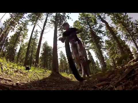
Descending through long-leaf pine.
In addition to the end points, the Virgin River Rim trail can be reached by
car where it crosses the Strawberry Point road, at Lars Fork, and at Cascade Falls,
Navajo Lake, and Webster Flat. These connections allow for shorter out-and-back
ride options and loop rides.
The most popular of these
shorter rides is the climb from the west end of
Navajo Lake to Navajo
Peak.
This ride also uses a bit of the popular
Navajo
Lake Loop trail.
The trail winds through forests of pine, fir, and aspen as it climbs to the ridgeline. Here,
you're on the southern edge of the Utah's massive high plateau country,
looking into the valleys
6000 feet below as they break downhill towards Zion National Park. The
Navajo Lake and Strawberry
Point sections of the trail let you admire these views, while the west
(Te-ah campground to
Woods Ranch) section is wooded and virtually view-free.

Chad looks down into the salmon-pink rock of the Pink Cliffs in this 2001 photo.

Much of the understory is sparse, allowing good sight lines.
The trail is fairly well-maintained considering its remoteness. There are trail markers at
most trail and road intersections, but it's possible to get lost after
the trail temporarily
joins a dirt road if you aren't paying attention.
The trail base is mostly hard-pack dirt, but there are a lot of rough rocky sections. Plan
for a few stiff-but-short climbs on loose rock that you'll probably hike-a-bike.
And although
the trail is designated non-motorized, you'll find a few spots where gas-heads
have poached
it and churned up the rocks for you. The eastern end (Strawberry Point
to Pink Cliffs) seemed
to have the toughest trail surface during my rides.

Cruising past the cliffs in this 2017 drone shot.

Mike stands at the cliff edge in 2001, 6 miles into the ride.
One of the ride's highlights is the view of the Pink Cliffs, an eroded rock formation similar
to Bryce Canyon. The pink and orange rock is soft limestone from the Tertiary
Period, called
the Claron Formation. This limestone formed in a large fresh-water lake
about 40 million years
ago. During this era, the uintatherium and giant sloth lived in Utah in
warm thick forest among
many lakes.

Bruce rolls toward Navajo Lake.
The eastern side is by far the toughest half of the ride, but it's also the most scenic. This section includes the amazing Pink Cliffs (definitely a big photo op!). And at Navajo Peak, you reach the ride's peak altitude of 9800 feet. If you do ANY part of the Virgin River Rim, you should do the eastern half.
The western half drops away from Navajo Lake, rolling through meadows of sheep, but still finding time to climb up and down. Compared to the high-voltage ride between Strawberry Point and Navajo Lake, the western end seems like just more riding.
This eastern side does have a few views, but it tends to be low voltage compared to those between Strawberry Point and Navajo Lake.

Heading through a meadow between the pines.

Dominic grinds along one of the dirt-road sections on the western half of the ride.
The last bit of the western side is a run down a dirt road. Anti-climactic. Once you arrive at Woods Ranch, you've done 32.5 miles with 4200 vertical feet of climbing.
Trailhead Strawberry Point, 9 miles up Strawberry Road
(Forest Service Road),
descend down road
0.5 leave Forest Service Road onto singletrack on right GPS N 37° 26.284' W 112°
42.129', altitude 9000 feet
1.8 cross Forest Service Road, altitude 8400 feet, begin climbing
2.6 doubletrack joins trail from right (continue straight)
2.9 exit doubletrack onto singletrack on left
3.5 cross doubletrack, then small (usually dry) creek
4.3 doubletrack merges in from left
4.4 exit doubletrack onto singletrack on right
5.3 cross doubletrack, then 2nd doubletrack 200 feet later
6.9 Lars Fork road on right side, cross loop of road (2 crossings), climb
switchbacks with road on right side
11.1 cross Cascade Falls road near overlook (trail is across road, left of outhouse),
altitude 9000 feet
13.5 intersect Dike Trail, altitude 9600 feet, continue straight and descend
14.7 intersect Spruces Campground trail on right, saddle at 9300 feet, continue straight, begin climb
15.5 top of Navajo Peak, altitude 9700 feet, generally flat and up-and-down
16.0 intersect Navajo Trail, keep left (straight), descending
18.5 merge with Navajo Lake Loop Trail, keep left (straight)
20.1 reach paved road, altitude 9100 feet (campground just across road has water tap), turn left on
road
20.2 go right on doubletrack GPS N 37° 32.020' W 112° 49.303' as road turns
south, begin descent
20.7 singletrack trail abruptly turns right off doubletrack (if you reach a
gate, you went too far), 9000 feet
26.5 turn right uphill on doubletrack, altitude 9000
26.7 fence/gate, continue straight ahead on doubletrack
27.1 doubletrack turns right in sharp switchback, go straight onto singletrack
at corner of switchback
27.6 reach Webster Flat road, look left - singletrack continues on the other
side of the bend in the road
28.3 top of mountain, 9400 feet, go over sheep grate in fence, descend
29.4 trail rejoins Webster Flat road, turn right on the road, descend
32.1 doubletrack reaches gravel road, turn right
32.5 road enters parking area at Woods Ranch GPS N 37° 35.455' W 112° 55.032'
Getting there: From Cedar City, drive 11 miles east
on U-14 to Woods Ranch. Leave a vehicle at the parking area of the second
entrance (the gravel road that comes in parallel to the highway is the end
of the trail). Continue east on U-14 to 33 miles from Cedar City, and turn
right on Strawberry Road and keep straight to Strawberry
Point, 9 miles. You'll pass the trail marker on the left-hand side of the
road about 1/2 mile before the overlook.

Map of the Virgin River Rim 32-mile ride.