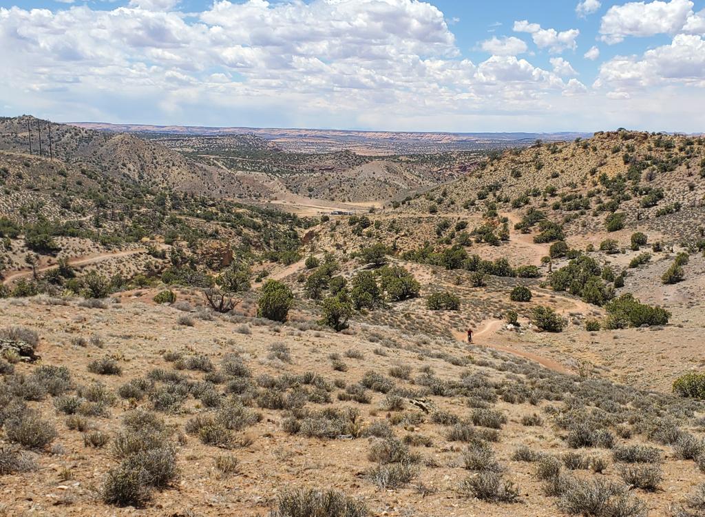
View of the UFO Trail as we descend toward Little Salty, with the Blue Hills area to the west. Ride description and photos April 5, 2012 by Bruce.
UFO TrailThe UFO mountain biking trail is part of the Klondike Bluffs system. This trail is a connector
between Baby Steps South and Little Salty. You reach it via other trails
in the system. I recommend
this trail as part of a 12-mile lariat loop (described below), or as a
bypass when riding the
Baby Steps Loop.
UFO is 1.6 miles long. There's no overall elevation change between the two ends. Up-and-down
riding creates 150 vertical feet of climbing when riding either direction.
UFO is one of the
easier trails in the Klondike system. Most of the trail is easy technical
and easy aerobic,
but in the middle of the ride there are a couple of switchbacks on a short-but-stiff
climb
that beginning riders will have to walk.
. This is the Di...")
We're just getting started on the 12-mile lariat loop (see below). This is the Dino Flow trail. Easy so far.

We've reached the junction with Baby Steps and are climbing uphill on slickrock.
UFO is about half dirt singletrack, with the remainder split between smooth slickrock and not-to-tricky
rollover rock. As of April 2012, the dirt sections are very soft because
the trail is new and
hasn't had time to compact. This will make the short climb over the ridge
hard, whichever direction
you ride the trail.
Most riders will use UFO as an alternative (bypass) when riding the Baby Steps Loop counterclockwise.
The classic Baby Steps Loop drops steeply off the escarpment to the east
on dirt road, then
heads north in the valley on flat jeep road before climbing back up. UFO
replaces all that
jeep road with singletrack.

After the slickrock climb, there's a short but boring stretch on doubletrack. Now we've reached the Baby Steps Singletrack and forked to the right at the sign. This is signed as expert tech, but it's not that tricky.

On a slickrock ramp after the second ST section (Baby Steps itself is going left to right in this photo), we reach this trail marker. That's UFO on the hillside above the bike, heading back downhill at the trail sign.
Another great ride using the UFO trail is a 12-mile lariat loop incorporating the first part
of Dino Flow, then Baby Steps south uphill, UFO, Little Salty downhill
to EKG, and the southern
end of EKG southbound back to Baby Steps before returning to the trailhead.
This ride is advanced
technical because of the Baby Steps Singletrack sections and EKG. There's
1350 feet of climbing.
Good riders can easily knock this ride out in two hours. The photos on
this page are from the
lariat ride.
On the south, UFO forks to the left when riding Baby Steps uphill. The connection is at mile
5.3 from the trailhead on the classic Baby Steps route, mile 5.5 if you
took Dino Flow to Baby
Steps. The connector is exactly 0.2 miles from the spot where the second
Baby Steps singletrack
section rejoins the doubletrack. You'll see a purple circle painted on
the slickrock. Loop
to the left and you'll see the trail sign.

The first mile of UFO is mostly smooth slickrock, first descending gently, then climbing slightly.

Handlebar view as we climb up the broad slickrock area.
When riding south-to-north, UFO starts with a short section of dirt singletrack (which many
riders simply bypass by coasting down the slickrock). It then descends
west on slickrock in
a shallow wash before turning northeast on a gentle slickrock climb.
There are occasional views to the west tward the Blue Hills area. The first mile of the ride
is very easy and is mostly smooth flat slickrock.

View from the trail to the west.

We're reaching the end of the smooth slickrock. We'll turn west and ride up and over a dirt ridge.
At mile 1 of UFO, you have to climb up and over a dirt ridge. This is the only tough part of
the trail. It's only modestly steep, but the switchback turns are fairly
tight. If the dirt
is loose (as it was April 2012), you may find it impossible to spin up
and around. With some
soaking rain and more bike tires (or some rock slabs placed on the trail
surface), you may
find these turns doable.
After descending the north side of the ridge, also through a couple of tight loose turns, you'll
come to a short section of rollover rock. This is the only techy section,
but there's nothing
too tricky. Here the trail descends toward the Little Salty wash.

Looking back at a climbing turn. The approach had six inches of powdery dirt. But it's a new trail. It will firm up.

Up and over the ridge, then descend through soft turns on the other side.
The trail hits Little Salty in a rock washbottom, just uphill from where Little Salty breaks
out onto the escarpment and begins descending more steeply. If you're
doing my lariat loop,
turn hard left downhill.
(If you're riding the altered Baby Steps loop, veer to the right uphill. Climb Little Salty
1/2 mile to the junction with the classic Baby Steps loop. Fork left uphill
on the doubletrack.
More climbing ahead.)
Back to the lariat ride. You've forked downhill on Little Salty. Ride the advanced tech rolling
sandstone surface downhill 1/2 mile, then fork left on EKG. (For an easier
return, keep going
downhill on Little Salty. When you reach Dino Flow, fork left to follow
Dino Flow back to the
main Klondike doubletrack.)

Heading downhill toward Little Salty, rolling over humps of rock.

Looking south at the fork between UFO and Little Salty. From here, uphill takes you to the top of the ridge where you can join the doubletrack section of the Baby Steps Loop. Our ride takes us downhill on Little Salty.
You'll spend 1.7 miles southbound on the technical rock of EKG. When you reach the trail sign,
you're back at Baby Steps South. Turn right downhill. Descend to Dino
Flow and turn left to
complete the ride.
Riding notes, 12-mile lariat loop:
0.0 Cross cattleguard, east on Klondike DT
N38 46.418 W109 42.735
0.8 DT splits, take ST in middle (Dino Flow)
N38 46.998 W109 43.072
1.9 R uphill on Baby Steps South (DT)
N38 47.590 W109 43.556
2.2 Junction w EKG, keep straight uphill
N38 47.746 W109 43.287
2.7 R off DT onto ST
N38 48.018 W109 42.880
3.5 Fork L (R=to Klondike)
N38 47.957 W109 42.584
4.0 L on ST
N38 48.286 W109 42.690

View down Little Salty as we descend.

The route is marked with orange paint as you navigate the sandstone.
5.3 Back to DT, L
N38 48.398 W109 42.772
5.5 L to ST UFO
N38 48.495 W109 42.905
7.2 L downhill on Little Salty
N38 48.778 W109 43.581
7.7 L on EKG
N38 48.589 W109 43.925
9.5 R downhill on Baby Steps
N38 47.746 W109 43.287
9.8 L on Dino Flow
N38 47.590 W109
43.556
11.0 Back at fork, straight onto DT
N38 46.998 W109 43.072
11.8 Back at parking
Bottom Line!The UFO trail created a way to complete a loop between Baby Steps and Little Salty, avoiding the doubletrack on the far side of the hill (on the old traditional Baby Steps loop ride). OK riding, like the rest of the Klondike system.

And heres the UFO itself, courtesy of Gene Poncelet...

Map of the Klondike trail system
Getting there: Starting at the Colorado River, drive
15 miles north from Moab. Look for a turnout with parking on the right and
a sign for Klondike Bluffs Road. There will
usually be cars parked there (GPS N 38° 44.452' W 109°
44.037'). For a longer ride, park here and ride up the road. Most cyclists will choose to go through the gate and drive 2.7 miles. Keep left at
the fork. At 2.8 miles, park your car in the broad parking area by the
fence. Go eastbound across the cattleguard through the fence and begin your ride.
Note: Map color-coded to show named trails individually.
Does not correspond to described loop above.
Northern Klondike TH: On Highway 191 8.5 miles
south of I-70 and 6.5 miles north of the southern Klondike Bluffs road
(about 5 miles north of the airport), watch for a "Northern
Klondike" sign at N38 49.504 W109 46.893. Turn east (toward the
sandstone bluff). Keep to the right as the road winds south around a small
hill. 1.2 miles from the highway as the road is heading east toward the
bluff, fork right on a fainter jeep road N38 49.103 W109 46.061, as the
main road continues to the dinosaur tracks. (Park here if the road is in
bad shape.) At mile 1.6, you'll come to the TH for the
Jasper and Agate
loops (N38 49.087 W109 45.625) on your right. At 2.0 miles, you're at the
bottom of
Mega Steps at a larger parking area N38 49.179 W109 45.417.
Ride Copper Ridge south to
Baby Steps to
connect to UFO.


. This is the Di...")