
 | Sovereign Upper Loop (Cedar Mountain) The Cedar Mountain loop is formed from a continuation of the Sovereign Singletrack plus the Cedar Mountain singletrack. The loop can be ridden as a ride in itself (8.5 miles), or included with upper Sovereign (10.2 miles, see below), or as an add-on to the Sovereign and Salt Wash system for very strong and experienced riders. The loop itself is 6 miles with 600 vertical of climbing. The "grand tour" from the Willow Springs trailhead is 20.5 miles and 2000 vertical. See the Salt Wash riding directions. |
| Upper Sovereign plus Cedar Mountain loop
(tougher): Drive or bike to trailhead at mile 1.7 on Dalton Wells Rd 0.0 R fork (ATV route) eastbound N38 43.586 W109 40.782 0.2 Keep straight, N38 43.66 W109 40.54 1.2 Hard L to Sovereign ST in wash N38 44.152 W109 39.823 1.7 ST reaches slickrock, keep L 1.9 ST exits slickrock on L 2.1 Stiff climb 2.3 Top of hill, fork L (gets sandy) N38 44.485 W109 40.124 (Alt R, then R on road to bypass sand) 2.8 Fork L, N38 44.127 W109 40.073 (straight = alternate, R at road to trail at 3.4) 3.3 L on road, N38 44.178 W109 40.470 3.4 R up smaller road, N38 44.145 W109 40.499 3.6 L on ST and drop into wash N38 44.254 W109 40.577 (straight = easier alternate, rejoins 4.5) 4.2 L and out of wash, N38 43.936 W109 40.744 4.5 Fork L, N38 44.119 W109 40.956 | 4.6 Fork R uphill into wash N38 44.084 W109 41.019 5.2 Fork L on Cedar Mountain N38 44.180 W109 41.358 5.8 Cross DT, N38 44.478 W109 41.200 6.2 Veer L along wash, cross DT N38 44.612 W109 41.350 Enter arroyo 6.5 Cross DT, N38 44.120 W109 42.361 6.8 At Brushy Basin Trail, keep L Option: R to Dalton Wells Rd 8.3 Keep straight (L=to DT) N38 44.091 W109 41.602 8.7 Fork R off loop, begin descent N38 44.180 W109 41.358 9.3 Bottom of wash, veer L N38 44.084 W109 41.019 9.4 R onto ST on rock, N38 43.936 W109 40.744 9.7 Fork R downhill in wash N38 43.936 W109 40.744 9.9 Exit wash, R on road, N38 43.846 W109 40.794 10.2 At parking |
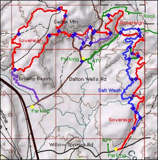 | Getting there, Dalton Wells Upper Trailhead:
On US-191
north of Moab, turn east on dirt Dalton Wells Road. As the cindered path
turns R, go straight onto the dirt road. If the gate at mile 0.2 is
closed, pass through and shut it. Cross the broad sandy wash. At mile
1.7, park at the fork in the road N 38°
43.584' W 109° 40.783'. The R fork takes you to the various upper
Sovereign riding options. The L fork takes you further on ATV track into
the valley where you can connect to the southern 6 miles of trail. Copyright 2007 Mad Scientist Software Inc. Trail conditions change. Use this trail guide at your own risk. |