
| Porcupine Singletrack and Kokopelli Trail
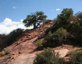
The Porcupine Singletrack runs along the edge of Porcupine Rim through a region of brush and pinion pine. (1) Shuttled Downhill: Kokopelli trail to the Porcupine Singletrack, then down the last 11 miles of Porcupine Rim. (2) Loop: From the Porcupine Rim trailhead, go up Sand Flats Road to one of three possible intersections of the Porcupine Singletrack, descend the ST then go the "wrong way" on the first 4 miles of Porcpine Rim to close the loop. |
Downhill, starting with Kokopelli, end Colorado River |
|
| UPS (Upper Porcupine Singletrack) Option Fork R on UPS at mile 1.9 3.7 Overlook at DT, cross to ST N38 34.529 W109 20.767 4.6 R at ST fork (L=Sand Flats Rd) N38 34.842 W109 21.453 All options now converge on same ST fork. See below |
|
 | ...From the T intersection of Lower
Porcupine Singletrack |
| Getting there, loop ride from Porcupine Rim
trailhead:
The Porcupine Rim Trail begins on the Sand Flats Road,
reached by turning left off Moab's main drag onto 300 South, then right
when the road ends, then second left. From the entry gate, drive 7 miles.
The trailhead is on the left, near the small cattle-watering tanks. Shuttle ride from La Sal Loop Road: Leave your shuttle car in Moab, or at the Negro Bill Canyon parking area on highway 128 north of Moab. On Moab's Main Street, head south on US-191. Zero your odometer at Center Street Center Street and drive 8.2 miles. Turn left toward Ken's Lake - La Sal Loop Road. At the T intersection 1/2 mile later, turn right. Climb uphill on the paved La Sal Loop Road. Around mile 25, watch for a doubletrack on the left with a sign "Kokopelli Trail." Start your ride downhill here. Copyright 2007 Mad Scientist Software Inc. Trail conditions change. Use this trail guide at your own risk. |