
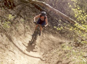
 | The Bobsled, via Bonneville Shoreline This famous downhill romp extends from the Bonneville Shoreline Trail down to the homes of the Avenues. It twists and turns downhill runs in a creekbed, 1000 vertical feet over 1.6 miles. This is strictly a downhill -- don't even dream of riding uphill on the Bobsled. You'll be roadkill. Riding the loop requires good aerobic capability for the uphill and advanced technical ability for the downhill. There's about 1/4 mile of steep loose rock at the beginning. Season is April through November. |
| City Creek Canyon Option (Northern Loop): Going west on 11th Avenue, keep right onto Bonneville Blvd and go downhill. Just before the City Creek paved road, find a small parking area on the right of the road, GPS N 40° 47.388' W 111° 52.709'. There's a stiff climb on singletrack, 650 vertical feet over the first mile, then a more reasonable rate of climb. To reach the Bobsled, you'll go 3 miles, with total elevation gain of 1250 feet. Pass the Terrace Hills access trail, with forks off right downhill on a hairpin left turn at around mile 2.5. Exactly 1/2 mile after this fork, you'll arrive at a multiple-trail intersection, where the Bobsled drops off to your right at GPS N 40° 47.859' W 111° 51.223'. Drop down the Bobsled 1.6 miles, then turn right onto Chandler, left on Terrace Hills, right on 11th Avenue, then right on Bonneville to return to the trailhead in City Creek. |
| Dry Gulch Option (Southern Loop): Follow 11th Avenue East until you come to Popperton Park. After parking, pedal east on the paved bike trail until it drops over the shoulder of the foothill into a wide gravel area. This is the Dry Gulch trailhead GPS N 40° 46.658' W 111° 50.225'. Turn left and begin climbing the Bonneville Shoreline Trail. At 1.3 miles from the Dry Gulch trailhead, you'll reach a ridgetop at 5650 feet. The Limekiln Gulch trail heads off on the left at GPS N 40° 47.166' W 111° 50.170'. Continue straight to mile 3.5. At an intersection of four trail options, the Bobsled drops into the canyon on your left at GPS N 40° 47.859' W 111° 51.223'. After 1.6 miles, turn right onto Chandler, left on Terrace Hills, left on 11th Avenue and continue east until you get back to Popperton Park. |
| Terrace Hills Option (Short Loop): On 11th Avenue, turn uphill onto Terrace Hills Drive, then immediately turn left into the parking area. From the parking lot, ride 0.65 mile up Terrace Hills to the trailhead, on your right at the dead-end. Climb another 0.3 to reach the BST. Keep right at the fork (left takes you down to City Creek) and climb southeast 0.5 miles to arrive at the top of the Bobsled, to your right at GPS N 40° 47.859' W 111° 51.223'. After the initial spooky steep loose-rock surf, you have 1.6 miles of twisting fun until you dump out on Chandler. Turn right to get back to Terrace Hills Drive. |
| Getting there:
On Salt Lake's North
Temple at around 5th East, head north uphill on E Street. When you reach
11th Avenue, turn left
(west) for the City Creek trailhead, right (east) for Terrace Hills or
Dry
Gulch. (See trailhead details and GPS under the loop options above.) Copyright 2002 Mad Scientist Software Inc Trail conditions change, and the layout of a trail may change without notice. Use this trail guide at your own risk. |
|
