
Vertical fins of rock create rockin' rollin' technical riding as the singletrack winds through the area. Photos by Bruce Argyle, July 23, 2001. Updated in 2010, 2016, and 2022.
Razorback
(Red Mountain Trail)The Razorback trail consists of singletrack and ATV track just outside of Cedar City. Because
it's lower in altitude (6000 feet) than most trails in the area, it's free of snow from May
to November. The climb in Razorback wash is intermediate in tech requirement, while the bandland
"fin" area is expert level.
It's a short loop with some advanced technical riding. Although only 3 miles in length, this
isn't a cushy ride. Top to bottom altitude change is only 200 feet, but
there are countless
quick ups and downs, plus a relatively strenuous half-mile grunt in each
direction.

We've just climbed out of the wash and are looking back south. A highly technical alternate downhill route is via the fin on the right. It starts pleasant, but gets hairy at the end.

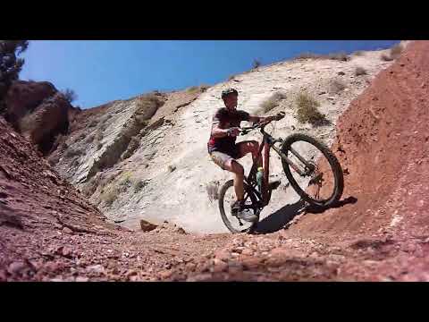
Bruce climbs up Razorback Wash.
There are four major entry points to the trail system. Two are from city streets. The recommended
starting points are the ATV entry from the road to Thunderbird Garden
trailhead and the trailhead
of Highway 14 just after you enter the canyon. My ride description starts
with the climb in
Razorback Wash from Highway 14.
From Highway 14, the trail gradually climbs as it winds around in Razorback Wash. Near the
top, it exits the wash on the left. (This exit point can be hard to spot
when there have been
rains. If you reach boulder piles that seem non-rideable, you've gone
too far up the wash and
need to backtrack.)

Most of the wash is fairly smooth riding with a gradual incline, but thunderstorms can cause severe erosion. Conditions can change dramatically from year to year.

Heading north on the main route. The fin here is broad and non-threatening.
The trail then reaches a ridgeline. The ATV trail is the first option on the right, then a
fairly steep DH line. The main trail stays flat on the ridge, then cuts
along the north slope
of the hill to the west of the ridge. From there, the trail follows sharp
fins of dirt and
rock. The turns are quick and constant; the sudden (but brief) uphills
are often brutal stand-on-the-pedals-and-grunt;
and the downhills have a definite thrill-factor. This trail is a good
workout, and it's a riot
to ride.
Since my original ride over 20 years ago, ATVs, motos, and DHers have created many alternate
lines. Navigation isn't so easy now. If you can't follow my GPS track
to the golf course, plan
to explore a few dead ends. Most riders just putter around; the classic
loop ride (as described
below) is done less often now.

While the washbottom climb is easy to follow, the northern end of the trail has competing paths that can be confusing.
 of this little razorba...")
View from the loop fork. Northbound, you'll go west (left) of this little razorback mountain. Southbound, you'll come back along the little valley at mid-right in the photo.
When the trail reaches a ridgeline and turns to the left, go to the next mountain and find
trail traversing the hill. (The first ATV track was your return route.)
Just remember that,
in general, you're heading north.
As you enter the little valley south of the golf course, work to the east (right). ATV track
will take you up a wash to the Thunderbird Gardens road. Turn right. Look
for another ATV route
southbound across from the flood-control pond. Follow this south back
to the ridgeline, where
you'll pick up your uphill track. You're going around that sharp little
mountain in the photo
above.

In the middle of the ride, the trail rises to its highest point on this fin, before descending sharply. Looking north, we see the farming areas north of Cedar City.

Rolling down a fin of red dirt.
The "badlands" over which this trail passes are sedimentary deposits from the Triassic Period
-- the age of reptiles, mammal-like reptiles, and the first bipedal dinosaurs.
The steep tilt
of the sediment planes was caused by "dragging" of blocks of rock by the
Hurricane Fault, a
southern version of the Wasatch Fault that separates the Great Basin from
the mountains of
eastern Utah.
This dirt erodes readily, rearranging the terrain. Add ATVs and motorcycles. So if my ride
description makes no sense, it's because things have changed. Fortunately,
civilization isn't
far away, so if you get hopelessly lost, just head downhill.
In the summer, you'll want to hit this trail early in the morning. 8 a.m. temperatures often
are in the low 60's, yet by 10 a.m. are climbing into the 80s. Because
you'll be working hard,
the cool temperature is very comfortable.

As we near the northernmost end of the ride, we're going to head up this wash to Thunderbird Gardens road, then catch southbound track by the catch-basin reservoir.

View on the eastern limb of the loop. Rolling ATV track. On the clockwise ride, there are a couple of steepish plunges that would be push-a-bikes in the other direction.
You may be a bit timid the first run around the loop. That's OK. Scout the territory, then
"tear it up" on the second loop. I guarantee, two loops will make you
feel like you've had
a ride.
Once you've finished a loop or two around the hill, you can plummet down the wash back to Highway
14 (assuming you started there). This is great fun, and worth doing more
than once. Watch out
for upbound traffic on the turns!

A typical trail segment, as the trail plummets and twists down the wash southbound. Note the vertical orientation of the rock strata.

Looking north down a fin from a spot where it isn't so deadly. Yes, the trail goes right along the tip top.
You may have noticed some singletrack trails forking off to the west. These "social trails"
head for the sharp fins of rock at the top of the ridges. I'm NOT going
to help you navigate
to them. You can quickly find yourself way over your head. Actually, you
may find your bike
over your head and broken limbs under your body. For example, there's
one route with 100 yards
of one-foot wide tech ribbon atop a sharp fin -- you can't stop, so you
keep going or you get
hurt. I'm not saying I rode this probably-illegal trail, but I swear I'll
never ever do it
again.
Riding notes, clockwise loop:
0.0 start up doubletrack in wash, find ST in bottom of wash
follow main path up wash (don't take any side
routes -- they're DH)
0.6 trail forks at top of ridge, turn left N37 40.799 W113 02.721
keep R at next intersections N37 40.730 W113 02.788
0.8 onto razorback ridges, avoid drop-off routes
1.2 descending off ridge, stay northbound
watch for sharp right turn onto dirt road N37 41.222 W113 03.142
1.4 work east as you approach the golf course
1.5 right onto gravel road N37 41.371 W113 02.991
1.7 Go right on DT at the flood reservoir
Southbound to ridge
2.0 Back at fork on pass, descend into wash vs R to razorback
2.4 back at fork on top of ridge, go left and descend into wash
3.0 back at trailhead

Map of the Razorback area
Getting there, SR 14 Trailhead: On Cedar City's Main Street, turn east
(towards the mountains) on Center Street, Highway 14. Travel 0.9 mile from the
turn. Note the dirt doubletrack on the left. Find a place to park (most
bikers use the truck-turnaround 100 yards up the road on the right).
Trailhead GPS is N 37° 40.441' W 113° 02.735'. Note: the larger parking
area further uphill (just past The Red Hill) is the
Red
Hollow trailhead.
Northern trailhead: As you drive east from Main Street on SR 14, turn left
on Highland Drive about 0.1 miles after crossing Coal Creek. Continue to
the "T" intersection south of the golf coarse and turn right. As
the road dead-ends by Dirt Foothills Drive, park. Start the ride
northbound on DT, keeping right of the flood basin. The path will veer
right around the base of the hill. The ATV path dropping through the wash
southbound (to your right) is the Red Mountain Trail.
Alternate, Rainbow Canyon: On SR 14, drive east. After crossing Coal
Creek, turn left on Highland Drive. Turn right at Rainbow Canyon. Continue
straight onto dirt road at Dirt Foothills Drive. Park in the elevated area
about 100 yards from pavement. Start the ride in the washbottom. Veer left
to join Red Mountain (the right fork takes you into a dead-end valley or
up onto terrifying high fins).
No water, camping, or bathrooms at any
trailhead.


 of this little razorba...")


