Trail view on Pipe Dream, as the trail winds around, up and down. Looking north....
Trail view on Pipe Dream, as the trail winds around, up and down. Looking north. Ride and photos by Bruce April 9, 2011. Latest update April 2018.
Pipe Dream

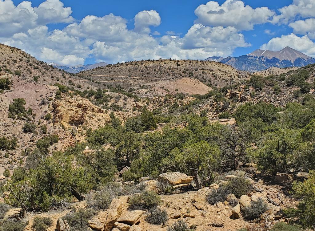
The Pipe Dream Trail runs along the steep slope just below the cliffs on the southwest corner of the Moab Valley. It's 4.7 miles in length and can be done as an out-and-back of 9.4 miles, or as an 8.2-mile loop ride by including the Pipeline Trail. You can also make a road return via US 191 and Kane Creek Blvd.

Technical features are upper-intermediate, but I have to give this trail an "expert" rating because of tight turns, rough embedded rock, and steep side-slopes. Bike control becomes an issue when you turn a tight blind corner with a drop-off to your side. Occasionally these tight corners have vertical rock on the inside, so you can't lean into the turn at all -- you must stay totally upright as you roll the edge of the trail.
Looking back southeast toward the Hidden Valley trailhead as we begin to climb t...
Looking back southeast toward the Hidden Valley trailhead as we begin to climb the slope. The snow-capped peaks are the La Sal Mountains (April 2, 2018).
Looking up the Moenkopi slope to the Wingate spires. At the arrows, the trail ha...
Looking up the Moenkopi slope to the Wingate spires. At the arrows, the trail has turned north and is beginning to gain altitude.
Starting altitude is 4150 feet. You'll climb only to 4600, but up-and-down riding will bring total vertical to around 1000 feet. It's not a cushy ride. Tight turns, dips, and twisting climbs will make you earn your miles.
Some riders have confused this new trail with an older route near the bottom of the valley. This old trail follows a pipeline route. So if somebody tells you that Pipe Dream is an easy quick ride and hardly worth doing, they've probably been on the wrong trail. My map shows you both trails.
Typical spot of armored trail surface.
Were on a little shelf area, 300 feet above the valley floor, still heading nort...
We're on a little shelf area, 300 feet above the valley floor, still heading north. A bit of green Moab Valley can be seen at upper right.
I rode the trail south-to-north from the Hidden Valley trailhead off US-191. The trail is easiest to find, and simplest to navigate when started from the south end. And there's a nice parking area at the Hidden Valley trailhead.

You can reach the trail easily from city streets for a north-to-south trip. But there's no obvious trailhead or parking. South of Kane Creek Blvd there are multiple connectors from city streets to the Pipeline, and many connectors from Pipeline to Pipe Dream. To ride Pipe Dream, always fork uphill.

Some bikers want to use this trail as a dirt return to loop Moab Rim and Hidden Valley That's a 16 mile ride with 3200 vertical. Keep in mind that the Hidden Valley trail requires a 1/3-mile rock-scramble that, guaranteed, will be one of the ugliest half-hours of your Moab visit.
The trail ducks under this boulder. Fun stuff. Rain is falling and the wind is h...
The trail ducks under this boulder. Fun stuff. Rain is falling and the wind is howling.
Now heres how you handle a dip through a little wash. A lot of work has gone int...
Now here's how you handle a dip through a little wash. A lot of work has gone into constructing this trail.
At the Hidden Valley trailhead, you'll find three trails. At the southwest -- uphill -- corner by the kiosk, the southbound trail is Hidden Valley. Pipe Dream starts just a few feet away, and heads west toward the mountain. It will turn north after it climbs away from the valley.

At the northeast corner of the parking is the Pipeline trail. There are a couple of lovely singletrack connectors on the northern edge of the parking lot that head north to the doubletrack Pipeline. These aren't the droids you're looking for.

Much of the trail surface is armored with slab stone to prevent erosion on the steep side-slope. This makes the ride a tad techy, and lot rougher on your body.

In a couple of wash-crossings, it was possible to drop a tire into off-angle cracks between two pavers. No biggie -- just watch where you're going.

Plenty of smooth cruiser areas between the dips and tech spots.
This photo shows the alignment of the two trails. Pipeline is smooth and boring,...
This photo shows the alignment of the two trails. Pipeline is smooth and boring, running through the valley. Pipe Dream hugs the steep side-slope higher on the mountain.
The trail generally gets more technical as you head north. Steeper climbs, sharper turns, steeper sideslope.

The video can give you a better idea of how techy the rockwork can be. This is an advanced-level trail; not for newbs.

Riding notes, south-to-north from Hidden Valley TH:
0.0   West on Pipe Dream N38 31.892 W109 31.039
2.6    Stay L uphill (R = to Pipeline) N38 33.028 W109 32.610
         Construction detour:
         R downhill, L at next fork
         R on Pipeline N38 33.098 W109 32.594
3.4    Stay L uphill (R = to Pipeline) N38 33.340 W109 32.888
4.2    Stay L uphill (R = Pipeline detour rejoins)
         N38 33.655 W109 33.327
         R downhill for loop return via Pipeline
4.5    R downhill (L=optional connection to Kane Crk Blvd)
         N38 33.805 W109 33.570
4.7    At street N38 33.889 W109 33.433
         Road return: R then L and ride to Kane Crk Blvd
         R on Kane Crk, R on US 191
8.9    Back at parking
Northern end of the trail.

A ride on Pipe Dream...

[Back to video list ]
Map
Map
Getting there, Hidden Valley TH:
On Main Street (US 191) in Moab, head south. At Kane Creek Blvd (McDonalds on corner), zero your odometer and drive 3.2 miles south on 191. Watch for a small Hidden Valley Trailhead sign on your right. Turn right on Angel Rock Road. Follow this road uphill and turn right on Rim Rock Lane at the T intersection. Continue to the trailhead parking, 1/2 mile from the highway. The Pipe Dream trail is in the southwest (uphill) corner of the parking area near the trail signs. (Don't be suckered into taking one of the northbound trails -- they go to the doubletrack Pipeline trail.)

In the map at right, the Pipe Dream trail is shown in green.

Bathrooms:  Moab Rim TH (loop)
Camping:  Multiple, primitive or pay, but none near trailhead
Water: none at trailhead
Bike services: many, see link below

Northern access (may change):
Doc Allen:  In south Moab, turn onto Kane Creek Blvd. Turn left on Aspen Avenue. At the T intersection, turn right on Doc Allen Drive and spot the trail 100 feet later on the uphill side of the street. Find a spot to park. (Note that at the time of this writing, there are NO parking areas at any of the access points for the northern end of the trail. Many are on private property.)
Kane Creek Blvd:  On Kane Creek Blvd, as you approach 500 West (the stop sign), note a trail heading steeply west uphill on your left. Shortly after passing the 500 West intersection, there's a southbound trail, also on the left side of the road.
Riding Resources for Pipe Dream:
Single-page riding guide
GPS track files (right-click and "Save as..."):
    GPX all area trails
    Pipe Dream only
    w Construction Detour
    Loop ride with Moab Rim and Hidden Valley (fool!)
Topo maps for printing:
    Pipe Dream
    Include Moab Rim
  Lodging, camping, shops:      Links to Moab area resources