Looking down the Moab Rim's initial climb as high winds usher in a storm. The band at the bottom is the Potash road, with the Colorado just out of sight. Photos April 9, 2011 by Bruce unless otherwise specified.
Moab Rim TrailThe Moab Rim Trail is one of the old classic "Must-Do" trails of the Moab area. But frankly,
it isn't one of our favorites. It starts with a climb that's as brutal
as anything you've ever
done. If it's a weekend, you'll play "dodge-em" with a gazillion jeeps.
This is a trail you
ride mostly for chest-thumping purposes. But the views aren't bad.
This trail is definitely advanced technical and strenuous aerobic. It's 10 miles as an out-and-back,
and you'll climb around 1800 feet total.
The trailhead is on the Kane Creek road along the Colorado, about two miles from the middle
of town. Starting altitude is 4100, and the high point is 5300 at the
viewpoint over the valley.

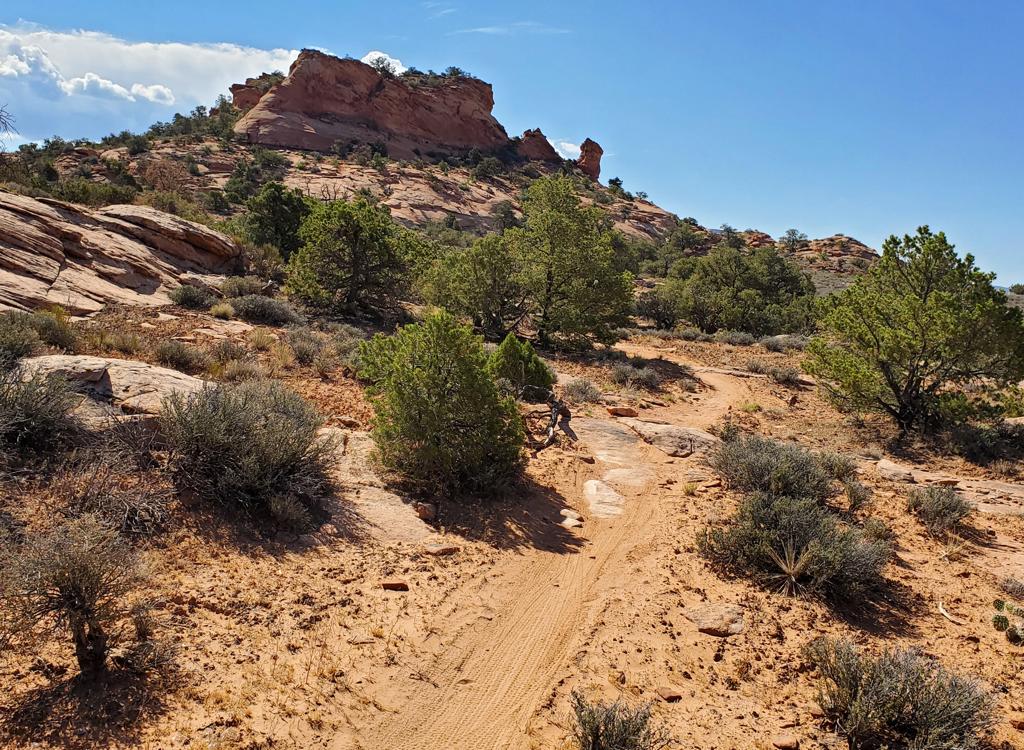
From the parking area, the trail crawls around the big rocks then climbs the bare patches left to right.

Chad Hunter grinds up from the Colorado River with UtahMountainBiking office boss Mike Engberson in pursuit. The rock is so rough and steep that bikers outride the jeeps, both uphill and downhill. April 16, 2000.
From the trailhead, the route climbs almost 900 vertical feet in less than a mile. Near the
top, the slope is an unrelenting 20% grade, pocked with fissures, ledges,
and wheel-traps.
You can usually find a side route around the big drops, but it's brutal.
Most riders will spend
considerable time walking.
This is the first, and worst of two big climbs. (The second comes right at the end on the last
0.8 miles to the viewpoint. This is 450 vertical for a 12% slope, but
it feels steeper because
loose moto-churn rock chunks scattered over the slickrock messes up the
traction.)
The grunt climb up the Rim is on uptilted ledges of Kayenta Sandstone. The Kayenta is a hard
layer with lots of silt in the sandstone matrix -- a sandy mud-plain deposit
where dinosaur
tracks are common. The Kayenta protects the underlying Wingate Sandstone
from breakdown, allowing
the Wingate to form cliffs up to 400 feet in height.

Looking down at the Colorado River, about 1/3 up. The cliffs at right are Navajo sandstone, with bands of Kayenta appearing underneath at the far right.

Approaching the first viewpoint. Almost there!
At the top, the familiar mounds of Navajo Sandstone sit on top of the Kayenta layer. On this
western side of Moab, the Navajo lies hundreds of feet higher than to
the east. See our
Geology
of Moab
page.

Looking to the southwest as storm clouds build over the La Sal Mountains.
At this first viewpoint, you're at 4900 feet with views of the Moab Valley both north and south.
The volcanic La Sal Mountains rise to the east.
As you leave the first summit, the trail rolls up and down some brutal rock outcroppings. There
are short pits of life-sucking sand between bits of rough rock. Occasionally
there's smooth
Navajo to ride on, but mostly it's rough, ridged Kayenta. The terrain
is very pretty, and the
views are good.

After leaving the viewpoint, the doubletrack trail rocks up and down, with varying degrees of tech.

Looking over the Navajo slickrock. If we do the full loop down Hidden Valley, we'll go through that first little notch at the left.
The trail goes up and down, never particularly technical or brutal. There is one steep pitch
up a Navajo sandstone dome, but nothing sustained and tough like the initial
climb.
The first significant trail fork is at mile 1.9. Keep right. (Left takes you down into a sand-infested
canyon where you'll have to hike your bike up the other side.) The trail
is well-marked with
carsonite posts.

Gary Argyle crests a Navajo sandstone dome on the Moab Rim on April 16, 2000.

Climbing to the viewpoint, we hit more rough Kayenta stone.
At mile 3.7, the Moab Rim trail forks hard left, drops through a little wash, then begins the
steep climb to the viewpoint. This is a grunt granny-gear climb. I found
the trail surface
littered with small angular chunks of sandstone torn up by motoheads.
It was easy to loose
traction. Just before the viewpoint, you'll fork right (east).
The Moab Valley is a sunken area where fault lines disturbed an underlying dome of salt. (This
salt was deposited by periodic flooding, then evaporation, of ocean water
into a deep inland
depression called the Paradox Basin during the Pennsylvanian Era, about
300 million years ago.
It's over 1000 feet thick and is mined for salt and potash west of Moab.)
As the salt was dissolved
by seeping water, the valley floor subsided.

View north.

Chad contemplates the meaning of life on a precariously perched slab of sandstone overlooking Moab. April 16, 2000.
The fault line also changed the height of the rocks on either side of Moab. To the west, younger
rocks are exposed, with cliffs of Wingate Sandstone and Navajo Sandstone
as a cap rock. To
the east, Navajo Sandstone is nearer the valley floor, with Entrada Sandstone
at the top. The
displacement along the fault occurred before the present-day Colorado
River began cutting into
the rock, then the falling of the valley floor occurred later, resulting
in the unusual topography
where the valley lies at right angles to the river gorge.
Back at the trail fork, you have two options: Head back the way you came, or fork left and
uphill for the
Hidden Valley
Trail. The Hidden Valley Trail forms a classic loop ride. It's very nice until you hit a 1/3
mile section of boulder-strewn steep portage. Then you'll be wishing you'd
done the out-and-back.
But if you absolutely MUST do a loop ride, there you are.

View southwest.

Heading back down from the viewpoint. Then on to Hidden Valley for the loop.
My recommendation is that you do the loop ride clockwise: CLIMB the ugly portage up Hidden
Valley, then descend Moab Rim. You can close the loop by road, or you
can ride the new
Pipe Dream
singletrack. See the map and track files.
Riding notes, to viewpoint from Moab Rim
TH:
0.0 Start grinding up the Rim
0.9 At the top, veer R on DT
1.1 Fork R (L = viewpoint)
1.8 Fork R
2.0 Climb slickrock
3.5 DT joins on L, keep straight
3.7 Fork L for Rim (R = Hidden Valley)
4.5 Petroglyphs
R fork to Rim
5.0 Viewpoint at Rim

Map of the Moab Rim
Getting there: Head south on
Moab's Main Street. When you reach the McDonald's on your right, turn right onto Kane
Creek Blvd. After 1.5 miles, go straight at the "Yield" sign where the road
seems to turn right. Go past the Moab Rim chairlift to 3.5 miles from McDonalds at GPS N
38° 33.541' W 109° 34.979'. The trailhead is on your left.
Bathroom: Moab Rim trailhead
Camping: Many, along the Colorado and at Kane Creek
Water: Moab
Bike services: Moab