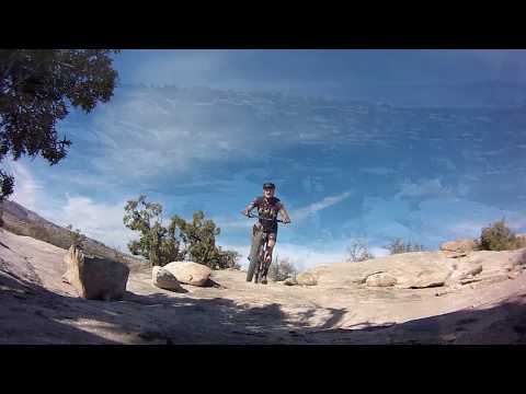
Typical trail view on slickrock, with green paint stripes indicating the riding line. Green means we're on the Dunestone Trail. Original photos and trail review November 5, 2012 by Bruce. Latest update November 2017.
Klonzo System North TrailsThe Klonzo Trail system is non-motorized singletrack designed for
mountain biking. It lies east of the
Sovereign
/
Salt Wash
trail system near the border of Arches
National Park. The trailhead is on Willow Springs Road 10 miles north
of
Moab. The riding is fun and easy. This page covers the north trails.
For more riding in this area, see the
Klonzo
South
,
Gravitron/Vertigo
and
Klonzo Beginner Slickrock
pages.
The trail system has multiple interconnected loops. Each segment is quite short. You'll rarely
ride more a half mile before reaching another trail fork. The ten trails
of northern Klonzo
are Boondocks, Borderline, Dunestone, Cross Canyon, Gravitron, Secret
Passage, Snippet, VertiGo,
Wahoo, and Zoltar. The multiple connections between loops offers many
different riding experiences.

Trail fork where Dunestone meets Boondocks. Now purple paint indicates the riding line.

Color coded map. Color coded ID posts on the trail. Color-coded paint stripes on the rock. Seriously. If you get lost on this trail, it's time to give up the booze.
Trail signs at each intersection keep it from getting confusing. Each sign has a "you are here"
smiley-face. Colored stripes on the rock or color-coded carsonite markers
identify the trail.
(The color codes correspond to the map's colors.)
There's a total of 12 miles of trail at Klonzo north of Willow Springs road (with more great
trails in
Klonzo
South
). Some are pure undulating dirt singletrack (example Secret Passage). Others are almost all
rock (example Dunestone). It's a good mix for pedaling around in circles
and just enjoying
the ride. To hit every piece of every trail requires some short "do-overs"
so your "do it all"
ride of Klonzo North will be 13 to 14 miles.

Looking west from the trail as Bruce hits Dunestone to make a trail video.

Cactus and paintbrush were blooming during my May "update" ride.
Base altitude is 4400 feet. Total altitude change is 400 feet from the parking area to the
top of the Wahoo trail. There's a lot of up-and-down riding, though. A
do-it-all ride will
total about 1500 vertical.
Technical difficulty: early intermediate to advanced. With the exception of the two new advanced-tech
trails on the north end, there wasn't anything tricky on this ride, so
I'd rate the trails
as appropriate for advanced beginners. True beginners may struggle on
the narrow slope-hugging
trails in the red dirt section and on a couple of short stiff climbs.

About as tricky as it gets. The connector of Boondocks climbing up to meet Dunestone. This is the steepest roughest 20 feet of climbing on the entire Klonzo trail system. And it's not that hard.

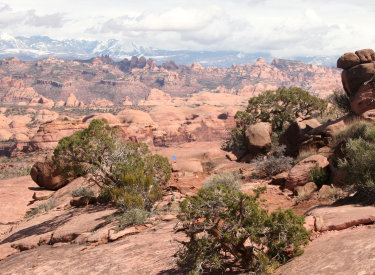
The higher spots on the Klonzo trails give you great views of the La Sal Mountains in the southeast.
Aerobic requirement: easy to moderate. Out-of-shape riders can mosey along. Expert riders can
hammer it and get a good workout. And because there are so many opportunities
to "finish" the
ride at the next trail fork, you can tailor your ride to the time available
and to your exercise
tolerance.
There are wide views to the south and west from the mesa. But this is not a "destination ride"
that goes someplace. It's a riding area where you select among route options
and just enjoy
pedaling along.

Looking southwest from the Wahoo trail. The break in the cliffs on the left side of the photo is where 313 heads west to Canyonlands.

Typical view on the Boondocks trail. Solid intermediate riding. Nothing tricky here, but a great system to improve your bike-control skills.
The sandstone is the Salt Wash member of the Morrison Formation from the late Jurassic Period.
It's about 140 million years old. There's a gentle upslope to the rock
as you ride from west
to east and from south to north.

Boondocks: heading north clockwise. Winding fast-paced dirt ribbon.
Boondocks
Configuration: Loop with connecting trails at top and bottom
Connections: Dunestone at mile 0.2 from parking, Dunestone at top of loop via
0.2 mile connector.
Character: Winding dirt singletrack west, hugging edge of mesa among rocks on
east
Length: Around and out clockwise 1.8 miles (with 0.4 mile repeat segment)

Borderline: climbing north. Undulating dirt ST on lower half, slickrock upper half.
Borderline
Configuration: Straight up the hill going northeast
Connections: Parking B 0.5, Cross Canyon 0.6 and 1.0, Snippet 1.3, Wahoo 1.7
Character: Winding dirt to mile 1.0, then slickrock and rolling rock on upper
portion
Length 1.7 miles

Cross Canyon: heading south. Carves a dirt path between lower Borderline and Wahoo, connects to just about everything.
Cross Canyon
Configuration: Winding North to South from Yahoo to Borderline
Connections: Starts on Borderline 0.6, Dunestone 0.2, Secret Passage 0.3, upper
Secret Passage 0.9, Snippet 1.0, Wahoo 1.3
Character: Winding dirt singletrack, tends to follow ridgeline
Length 1.3 miles

Dunestone: heading east. Rolling sandstone; a nice confidence builder for beginners.
Dunestone
Configuration: Loop with connecting trails bottom (TH) and at top
Connections: Boondocks 0.2 and 0.8 clockwise, loop fork 1.0.
Character: Slickrock and rollovers among juniper
Length: Around and out clockwise 2.1 miles (with 1 mile repeat section)

Gravitron: an armored turn-and-drop, whoosh up and drop again, early in the ride heading northeast.
GravitronConfiguration: One-way arc ride from top of Wahoo to Gravitron
Connections: Starts north end of Wahoo, ends in middle of Gravitron
Character: Advanced tech trail, a lot of whoops and drops, generally
downhill
Length: 1.9 miles
[
see trail page
]

Secret Passage: counterclockwise, looking west -- whoosh.
Secret Passage
Configuration: Arc circles away from Cross Canyon and rejoins
Connections: Leaves Cross Canyon at mile 0.3, rejoins after 0.7
Character: Winding dirt ribbon, counterclockwise (from top) offers fun descent
Length 0.7 miles
Snippet
Configuration: Shortcut between Borderline and Cross Canyon at midmountain
Connections: Starts at mile 1.3 of Borderline, mile 1.0 of Cross Canyon
Character: Ridgeline ST
Length 0.2 miles

VertiGo: Dropping to the south on bendy twisty fun stuff.
VertiGoConfiguration: Arc ride connecting Cross Canyon to middle of Secret Passage
Connections: Cross Canyon just below Wahoo Loop, Secret Passage at west end
Character: Advanced technical, some tight squeezes and traverses on steep slope.
Length 1.1 mile
[
see trail page
]

Wahoo: Cruising through the sandstone on the south end of the loop.
Wahoo
Configuration: Loop at top of trail system
Connections: Secret Passage ends on lower loop; Borderline ends near top of loop
Character: Half rolling slickrock and half winding dirt ribbon, recommended
riding direction counterclockwise
Length: 1.7 miles

Zoltar: Looking north, heading toward the junction with Borderline.
ZoltarConfiguration: North-South route on east side of riding area.
Connections: Extends from from junction of Borderline with Cross Canyon (1 mile
up Borderline from main parking) to the beginning of Houdini (see
Klonzo
South page) on Willow Springs Road
Character: Rolling patches of slickrock in area of juniper and brush
Length 0.6 miles
Beginner Sandstone Ride: Dunestone LoopThis loop is quick and fun with great views and non-threatening sandstone. From the west trailhead,
climbhill. Go right at the first fork to stay on Dunestone. Keep straight
(left) at the next
fork (if you even see it). Keep right as Boondocks rejoins.

Juniper, bitterbrush, and pinion pine erupt from the sandstone of the mesa.

We're heading south along the mesa edge on Dunestone.
Fork right at the prominently paint-marked green-to-green intersection at 1.0 miles to stay
on the Dunestone loop trail. (Straight takes you down off the mesa.) Ride
around the mesa,
then fork hard left to return the way you came. This ride is 95% sandstone,
just two miles
long, and has about 100 vertical feet of climbing.
Intermediate Quick Ride: Perimeter 5.3 milesThe perimeter ride will give you a quick taste of what's out there, without a big time commitment.
For this ride, just go right. Every time. Go right out of the parking
lot to ride uphill on
Borderline to Wahoo. Turn right.

Heading uphill on Borderline.

Rebel bike at the junction of Borderline with the Wahoo loop. Counterclockwise is the recommended riding direction, so you can enjoy a whooshing downhill without pausing for climbers on the narrow ribbon of singletrack.
When Wahoo brings you to Cross Canyon, turn right and head south. Turn right again to take
another whooshing downhill on Secret Passage. Climb up to Dunestone. Then
drop to your right
off the mesa on Borderline and head back to parking.
Strong Intermediate Do-it-all Loopy-Loop: 12 milesThis ride starts from downhill left and progresses, loop by loop, to uphill right. An exact
description of every trail fork gets pretty tedious. Just ride around
in circles until you
get there. Who cares if you don't follow my exact itinerary? It's all
good. If you're up to
it, you can add the advanced-tech trails VertiGo and Gravitron to the
north end of the ride.

We've reached the Salt Wash sandstone and are heading uphill east along the escarpment.

Climbing back uphill on Secret Passage, southbound and heading for Cross Country.
I started with the Boondocks loop clockwise. After repeating the western 0.4 miles, I caught
the connector to Dunestone.
I rode Dunestone clockwise, repeating the
north segment before dropping to Cross Canyon.
I dropped south (right) on Cross Canyon to Borderline and climbed uphill until I reached again
reached Cross Canyon (but uphill from where I left it). I took Cross Canyon
north and forked
left (west) on Secret Passage. Secret Passage looped back to the Borderline-Cross
Canyon junction.

At the top of the Wahoo loop, we're looking west. Lots of downhill curving turns ahead.

Climbing back uphill on sandstone toward the junction of Borderline and Wahoo.
Next I climbed Borderline to Wahoo. Once around Wahoo counterclockwise (full loop). Down the
rock of Borderline to Snippet, Snippet to Cross Canyon. Cross Canyon back
up to Wahoo. Loop
around Wahoo again, all the way back to the Cross Canyon junction.
Now I turned on Cross Canyon and rode all the way south to Borderline. I forked right on Borderline
and followed it back to Parking A.

Looking toward the La Sals from Borderline as we head home.

Map of northern Klonzo system
Getting There:
Western Trailhead: Willow Springs Road forks east off Highway 191 18 miles
south of I-70 and about 10 miles north of Moab (1.8 miles north of the
junction with Highway 313 (to Canyonlands and Dead Horse Point). Turn onto
Willow Springs Road. Keep straight as spurs go to camping areas. At mile
1.4, turn left to cross Courthouse Wash (may not be passable in wet
weather). At mile 2.0 pass the Sovereign Trail parking area, a flat area
outlined in rocks on the left (north) side of the road N 38°
41.876' W 109° 39.868', with a natural gas pump building on the
right. At mile 2.7, turn left off Willow Springs Road onto a small
doubletrack. 100 feet later, park and begin your ride. The trail on the
left takes you clockwise and immediately to the slickrock.
Eastern TH: Keep going on Willow Springs Road past the west trailhead. At
mile 3.0 from US 191, turn left on doubletrack. Drive 0.2 miles to a small
area of slickrock. The trail to the left goes toward the western
trailhead. Right climbs up for a counterclockwise loop.
Midway and Redhot TH: Keep on Willow Springs Road past the first
trailhead, then keep right at the fork (at mile 3.0 from US 191). There
will be a few parking spots at the entry to the Midway trail and at the
Houdini/Redhot/Zoltar trails.
Bathrooms: None at Sovereign or Klonzo
Water: None
Camping: Primitive spots along Willow Springs
Road Commercial camping across from 313.
Nearest supplies: Gas and quick-stop on 191 across
from 313, 1.7 miles south of Willow Springs road.