

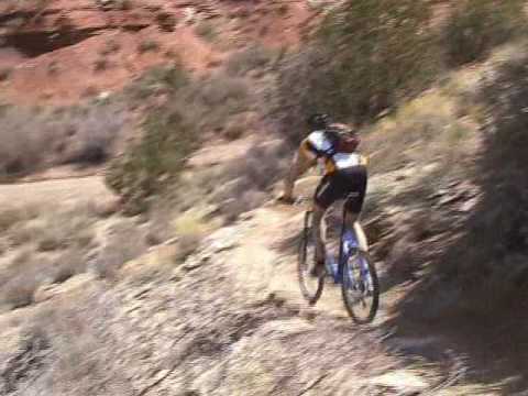

The JEM Trail is found just west of the town of Virgin near Zion National Park. It remains one of the most-popular rides in the Hurricane area. Named for trailblazers John, Ellen, and Mike, this trail offers high-speed desert cruising and a cliff-side ride along the Virgin River. Except for one dangerous switchback (which you can walk), it's an easy technical ride.

 trailhead. T...")
Important note!
In 2015 the upper 2.1-mile portion of JEM became one-way downhill only. This is the section
from the Highway 59 trailhead down to the
Goosebumps
/
Dead
Ringer connector
intersection. When climbing to the Highway 59 trailhead, you must use either
Dead Ringer
or the
JEM Doubletrack
.
And in 2022 the lower 1.8 miles also became a one-way DH. From the lower (Virgin) JEM trailhead to the Hurricane Rim trail fork, you must use Carne Asada when climbing uphill.

In Hurricane, turn south on US-59 (towards the Grand Canyon). Drive exactly 5 miles uphill. Turn left on cindered doubletrack right as you approach the base of Gooseberry Mesa. Drive another 0.3 miles to the parking area. Cross the cattle guard at the gate, then immediately turn right on singletrack. This section of JEM is one-way only.
, just 100 feet from the trailhead at the end of the doubletrack.")
In La Verkin, turn east onto Highway 9 toward Zion National Park. Drive 4 miles uphill. Just after you reach the first homes approaching Virgin, find the cindered Sheep Bridge Road on your right. Descend toward the bridge across the Virgin River and find a parking spot along the road. Start pedaling. Just past the bridge, but before the cattle guard, there's a dirt road to the right. This will take you to the bottom of JEM and Carne Asada. (The parking directly at the bottom of JEM is reserved for the nature conservancy.)

This trailhead with bathroom and bike stand is found
half-way along the gravel Sheep Bridge Road, which connects US-9 to US-59. Drive toward
the upper JEM trailhead on Highway 59 as above. But at mile 3.3 (while
still on the flat area), turn left on gravel Sheep Bridge road. Drive 2.9 miles on Sheep Bridge
road to a fenced parking area with a bathroom. Cryptobionic and
northern Dead Ringer can be found here.
Option, roadside
parking off US-59: If you turned onto Sheep Bridge Road from Highway
59, immediately park on the
right, just inside the fence. Pedal 0.4 miles northeast to where the JEM
singletrack crosses.

From Highway 9 in Virgin, turn south onto Sheep Bridge Road. Drive 1.7 miles. As the gravel road drops into a dip, there are two paths on your right. The ridgeline road is the race staging area. There's a connector to Carne Asada in about 100 feet on your right. The second dirt road, around 50 feet downhill, is the primitive camping and trailhead area. JEM crosses this road at the bottom of the camping zone, and Carne Asada is found to your right on JEM downhill from the road.

This trailhead serves the Hurricane
Rim and Gould's trails. Other trails in the system are reached via these
trails. In Hurricane, turn south on US-59 (towards the Grand Canyon).
Follow the road uphill 0.9 miles, then turn left into the trailhead
parking near the cell phone towers. The dirt road 0.2 miles back down U-59
is the trail's start.
Option, Gould's Wash corral: As you head uphill on Highway 59, pass
gravel Sheep Bridge road on your left (about half-way between Hurricane
Hill and the JEM trailhead). Now watch for a dirt road on your right. It
will take you to the corral. If you're heading for the rim, go directly
west from the corral for 1/2 mile.
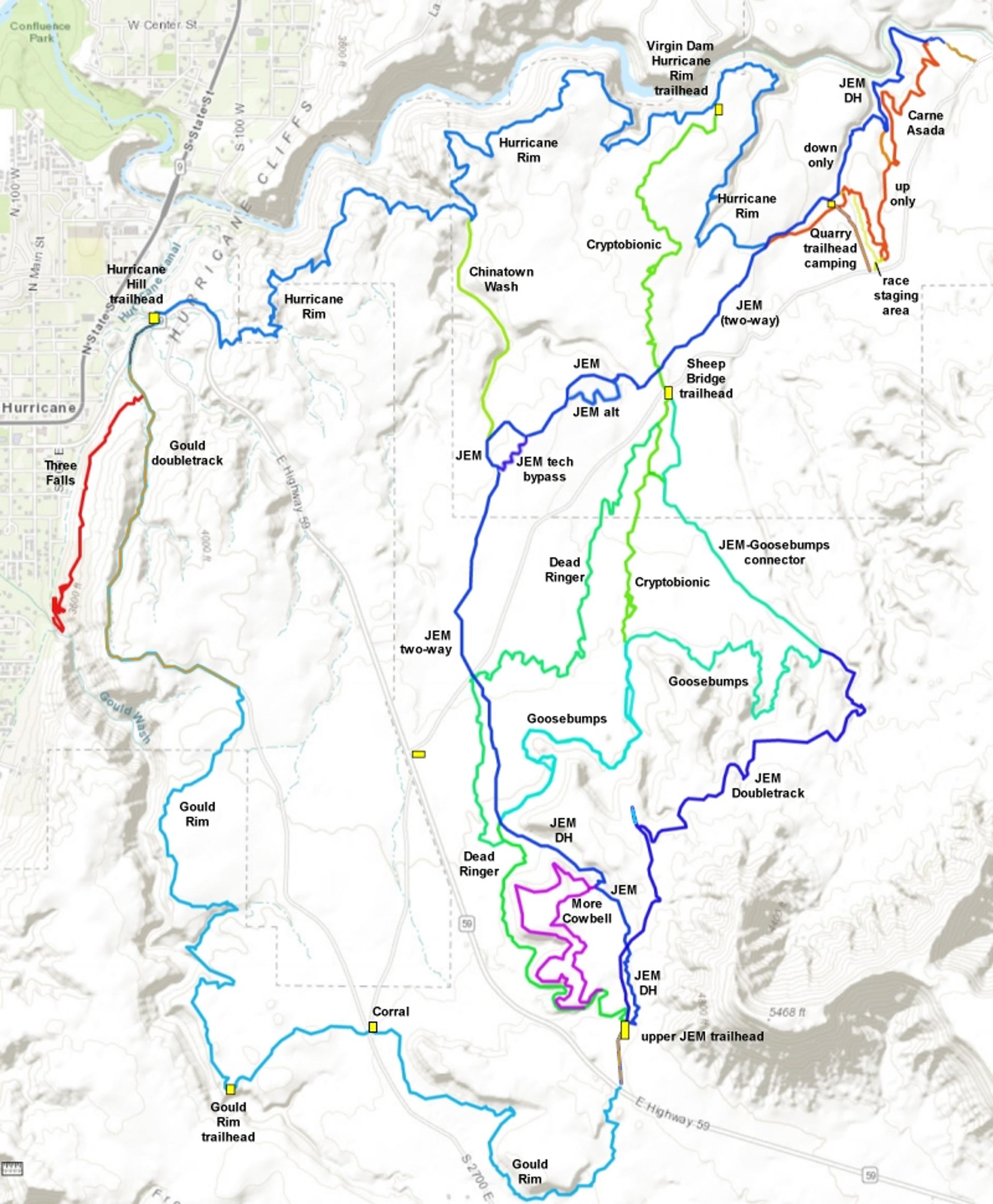
See our topo map below for an overview of the area trails. Navigation is fairly easy, but a cell phone with a trail App always helpful when deciding where to ride next as you stand at a trail fork. The trail is well-marked with carsonite posts.


(1) Out-and-back figure-eight. From the lower parking on Sheep Bridge road near SR-59, Carne Asada uphill to the Hurricane Rim trail fork. JEM uphill on the two-way section to the Dead Ringer fork at mile 5.3. Up the hill on Dead Ringer to the upper (Highway 9) trailhead, then down JEM back to the Virgin trailhead.
(2) Top to bottom with shuttle from the lower trailhead off SR-59 the upper JEM trailhead on SR-9.
(3) As part of the Goulds and Hurricane Rim loop ride, doing the 5 miles of JEM that lies between SR-9 and the Hurricane Rim trail fork in a counter-clockwise ride.
Then there's the old classic JEM Loop, which is 12.9 miles in length with 800 feet of altitude gain. The first half of the classic JEM loop is uphill doubletrack ; the last 6.2 miles is downhill singletrack. While fewer riders are using this route now, it's an alternative for groups who want to ride side-by-side on the way uphill.


Most of the JEM trail is straight-forward dirt cruising. But there are some steep spots, and a rocky spot or two.
Remember that the middle section of JEM (from the Goosebumps cross-over down to the race staging trailhead) is two-way riding. Expect to see some riders going the opposite direction.
There are two alternate lines on middle JEM. The upper alternate is a wiggling route that bypasses a big rocky hill, and the other is a simple meander that bypasses another (mildly) steep section.
This alternate line is 0.4 miles long, and is a smooth winding cruise. It bypasses a 0.2-mile stretch of JEM that has 50 feet of elevation change. There are a couple of little rock-drops in the middle of the JEM trail on the main route, so the meander is used mainly as an alternate southbound climbing route.
The bottom of the meander is found 0.3 miles uphill from where JEM crosses the Cryptobionic trail, to your left. In the downhill direction, the top of the meander is on your right 0.3 miles from where JEM and the JEM tech bypass rejoin.


The JEM tech bypass is a short winding stretch of smooth singletrack that bypasses a steep rocky hill. Beginning riders and kids will appreciate this section. It's 0.3 miles long, bypassing 0.4 miles of JEM.
When riding JEM in the uphill direction, you'll find the bypass 0.7 miles from the spot where you crossed Cryptobionic near Sheep Bridge trailhead. As you cross a rocky dirt road, the entry to the bypass is to your left, about 30 feet down the road.
In the downhill direction, you'll find a carsonite post at a "T" trail intersection 0.9 miles from where you crossed Sheep Bridge Road. The left fork takes you on traditional JEM (and to the China Wash trail and the rocky climb), while right climbs the tech bypass trail.
, the smooth bypass trail is to your left as you cross this dirt road.")
, this intersection takes you to the tech climb (left) or the bypass (right).")

Ride log for the downhill on JEM:
0.0 Cross cattleguard, then right on ST along the fence
0.5 Cross doubletrack
0.8 Keep R at More Cowbell connector, drop off mesa
1.4 Cross Goosebumps/Dead Ringer connector
2.1 Cross Dead Ringer, then Sheep Bridge Road
(trail becomes two-way!)
3.1 Fork L (R = bypass)
3.2 Keep R at Chinatown Wash fork
3.6 Rejoin tech bypass
3.9 Keep L (R = meander alternate)
4.1 Meander rejoins on R
4.2 Cross Cryptobionic
5.0 Keep straight (R = climbing route, L = Hurricane Rim)
5.3 Trailhead/Camping area, connector to road on R, keep L
5.9 Connector from Carne Asada on R, keep L
6.7 Carne Asada on R, keep L
6.8 Gorge trailhead, take DT out
7.0 Sheep Bridge Road TH


One of the best trails in the area, very popular. The trail is a fun ride, and definitely worth doing. The views into the chasm of the Virgin River are awesome (note that you'll miss this section of JEM if you're riding the Hurricane Loop option). The high-speed singletrack descent is a blast. A good choice for mixed-ability groups! The JEM trail is a must-ride for your bucket list.

Start from parking area on US-59 above Hurricane
0.0 R (downhill) on US-59
0.2 L uphill on DT
1.8 Top of DT climb
2.3 R off DT onto ST
N 37 09.606 W 113 16.330 Alt=4000'
5.4 Trailhead, L on DT, head NE
N 37 08.142 W 113 16.280
6.2 At corral, find ST rear on R
N 37 08.310 W 113 15.649
8.0 ST comes in from R
8.3 US-59. For Big Loop, cross to DT
N 37 08.096 W 113 14.564 Alt=4350'
For small loop, head downhill on road
8.6 JEM Trailhead, cross cattleguard
N 37 08.329 W 113 14.527
Immediate R onto ST
9.0 Cross DT, descend toward cliffs
9.3 Keep R (L=More Cowbell)
N37 08.863 W113 14.661
Drop off ledge on switchback
N37 09.119 W113 15.103
10.8 Keep R (L = China Wash)
N37 10.541 W113 15.154
11.0 Cross Dead Ringer
Cross Sheep Bridge gravel road
11.1 Cross Cryptobionic
N37 10.798 W113 14.354
14.0 Fork L to Hurricane Rim
N 37 11.261 W 113 13.862 Alt=3650'
15.8 Virgin Dam trailhead
N 37 11.781 W 113 14.109
(Cryptobionic start on L)
16.0 Keep L (R=Virgin Dam trail)
18.7 R across Chinatown Wash
Straight = Chinatown Wash trail
19.6 Dam trail rejoins on R
20.2 Panorama Point
N 37 11.169 W 113 16.179 Alt=3850'
21.5 Back at parking
Sheep Bridge Road trailhead: Found half-way along gravel Sheep Bridge Road, which connects US-9 to US-59. Drive toward the upper JEM trailhead on Highway 59 as above. But at mile 3.3 (while still on the flat area), turn left on gravel Sheep Bridge road. Drive 2.9 miles on Sheep Bridge road to a fenced parking area with a bathroom. Cryptobionic and northern Dead Ringer can be found here. Option 1, roadside parking off US-59: If you turned onto Sheep Bridge Road from Highway 59, immediately park on the right, just inside the fence. Pedal 0.4 miles northeast to where the JEM singletrack crosses.
Upper JEM trailhead: In Hurricane, turn south on US-59 (towards the Grand Canyon). Drive exactly 5 miles uphill. Turn left on cindered doubletrack right as you approach the base of Gooseberry Mesa. Drive another 0.3 miles to the parking area.
NOTE! There is no longer a "lower JEM trailhead." it has been closed by the nature conservancy.

Other Resources for the JEM Trail:
One-page riding guides to:
Classic Loop
Hurricane Loop
Connecting trails:
Hurricane Cliffs Trail
Summary page
Gould's
Connector
Carne Asada
Hurricane Rim Trail
Gould's Rim Trail
Goosebumps/Cryptobionic
More Cowbell (beginner
White Ledges loop)
Dead Ringer
JEM DT
Chinatown Wash
GPS track files (right-click and "Save target as..."):
GPX master file of area
trails
JEM only
JEM Classic (OLD) Loop track
Loop from Sheep
Bridge TH JEM - Hurricane Rim - Goulds - JEM
Loop from Hurricane
Hill TH Goulds-JEM-Hurricane
Loop
Area map (view and/or print):
Printable
topo map of trail system
Lodging, camping, shops:
Links to St.
George area resources


