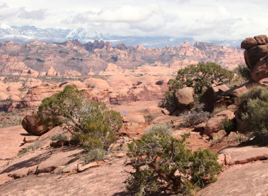
View west as a rider hits the dips north of southern Klondike Bluffs parking. Photos and trail review by Bruce on October 24, 2013.
Inside Passage
Inside Passage is a short trail starting at the southern parking for the Klondike Bluffs riding area . It connects back to the Klondike Bluffs trail after 0.4 miles. It bypasses much of the doubletrack trail that you'd share with motos.
Just so we're clear, the parking area where the trail starts is 2.8 miles from Highway 191
on the Klondike Bluffs Road. You'll find the trail at the northern corner of the fence.

Looking north from near the cattleguard marking the transition between the Klondike Bluffs Road and the Klondike Bluffs Trail. The squeeze-gate is too narrow to ride through, probably to keep motos off the singletrack.

Looking northeast as we climb up and over the low rise.
The trail climbs slowly over a low hill along the skirts of the bluff to the north. There's
about 70 feet of altitude gain before you descend back to the main trail.
The trail is very easy technically. It's suitable for beginning riders.

An older rider from England is enjoying the cruise back to his car. We're looking northeast. "Great little trail." he says, "All we've got is mud in the UK."

From the top of the knoll, we're looking southwest toward the parking area.
The base of the trail is clay of the Brushy Basin member of the Morrison Formation. This clay
may be green, purple, pink, or white depending on the location.
Cap-rock from the bluff litters the side of the trail and makes the ride visually interesting.
From the spot where the trail reconnects to Klondike Bluffs, it's about 0.2 miles to the
Jurassic
singletrack (on your left). It's another 0.2 miles on Klondike to the fork with Copper Ridge
Road and the
Dino Flow
trail.

Among the Buckhorn Conglomerate boulders, the trail zips down through an armored wash crossing. The conglomerate is more sandstone-like here than on upper Sovereign.

We're at the junction of the singletrack with Klondike Bluffs on the northern end, looking southwest.
I'd recommend that you take this trail whenever you're heading out from (or back to) the Klondike
Bluffs area from the southern parking area. It's not long or tough enough to add much effort
to your ride, and it sure beats riding doubletrack with motorcycles and jeeps.
Getting there:
Starting at the Colorado River, drive 15 miles north from Moab. Look for a turnout with parking on the right and a sign for Klondike Bluffs Road. There will usually be cars parked there (GPS N 38° 44.452' W 109° 44.037'). For a longer ride, park here and ride up the road. Most cyclists will choose to go through the gate and drive 2.7 miles. Keep left at the fork. At 2.8 miles, park your car in the broad parking area by the fence. Look for the trail at a break in the fence at the north corner.
Starting at the Colorado River, drive 15 miles north from Moab. Look for a turnout with parking on the right and a sign for Klondike Bluffs Road. There will usually be cars parked there (GPS N 38° 44.452' W 109° 44.037'). For a longer ride, park here and ride up the road. Most cyclists will choose to go through the gate and drive 2.7 miles. Keep left at the fork. At 2.8 miles, park your car in the broad parking area by the fence. Look for the trail at a break in the fence at the north corner.
From the north: As you head southbound, all trails will funnel into the Klondike Bluffs Road. After going through the sandy wash, you'll pass Jurassic on the left, then reach Inside Passage about 0.2 mile further on.

Map of the western Klondike riding area
Riding resources for this trail:
GPS track files (right-click and "Save as..."):
GPX Klondike area trails
Inside Passage only
High-res topo for printing (500 KB): View Klondike area
Lodging, camping, shops: Links to Moab area resources
GPS track files (right-click and "Save as..."):
GPX Klondike area trails
Inside Passage only
High-res topo for printing (500 KB): View Klondike area
Lodging, camping, shops: Links to Moab area resources