

Classic South Rim to North Rim Loop
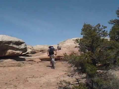
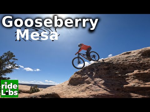
Gooseberry Mesa is a tabletop mesa just west of Zion National Park. The Gooseberry Mesa slickrock singletrack is absolutely world-class. Several trails allow you to pick your own brand of awesome. Once you've done it, you'll keep going back. This page covers the classic loop ride of the south and north rims. See also Goose Northeast , Secret Trail , Windmill/Bowls & Ledges , and White/Slickrock 101 pages.
 finds plenty to like. November 2003.")

This rock marks the boundary between the Triassic (reptiles, mammal-like reptiles, and early bipedal dinosaurs) and the Jurassic (bipedal carnivores such as allosaurus, four-legged plant-eaters such as stegosaurs and camarosaurs).
 | Unlike Moab's Slickrock
Trail, there are no brutal hill-climbs. Instead, the ride is a test of balance,
burst
strength, and reaction time: short ups, brief downs, and quick turns. You
can rarely see
where you're going to put the bike 20 feet later. Photos from our first visit to |
|

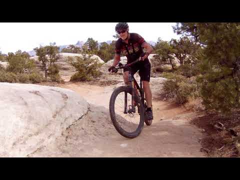
It's obvious that a lot of thought went into making this trail fun. This route was built by the local Harris brothers as a mountain bike trail, not as a horse or jeep trail.


Altitude change from the trail's beginning to The Point is around 100 feet. If you take the mesa road for your return, it will be slightly downhill on the trip back. For the beginner, the "Practice Loop" also known as Slickrock 101 features easy slickrock with no tricky stuff. Many bikers just head down the central road of the mesa (see map) -- it's a pretty good ride all by itself.
For bikers who want to see just how much abuse a bike can take, well, there's an opportunity every few yards. In God's Skateboard Park, you'll find stunts ranging from the merely difficult to the truly insane. But -- here's the beauty of Gooseberry -- a good intermediate rider can take these same trails without feeling he's endangering life and limb.

There's no water at the available on the mesa. There's a toilet at the fork in the road about a mile from the Cattle Grate trailhead. There's a bike shop in Springdale (10 miles away), where bike rentals, repairs, and maps are available. Rough camping is allowed on the mesa (no formal campsites). Yurt camping is available on the north rim, click [ here ] for information.


This is the ride described below. We started doing this loop during the previous century! You get the Cattle Grate, God's Skateboard Park, Rattlesnake Rim, the Point, Yellow, and the North Rim. Nice fast ride. See resources at bottom of page for track files!
Begin South Rim
0.0 ST south (right as you enter parking)
Cattle Grate Trail
N 37° 08.498' W 113° 10.304'
1.4 Trail touches mesa road, turns away
N 37° 08.492' W 113° 10.884'
1.7 Trail touches road again
God's Skateboard Park
N 37° 08.444' W 113° 11.022'
3.2 Merge R onto small DT
N 37° 07.991' W 113° 11.270'
3.4 L off DT onto ST
Rattlesnake Rim
N 37° 08.078' W 113° 11.336'
4.2 Keep L (R to Hidden Canyon)
N 37° 07.792' W 113° 11.712'
6.5 Straight for Point (R on DT = N Rim)
N 37° 08.440' W 113° 13.047'
Side Trip to Point
7.0 The Point (view, turn back)
N 37° 08.533' W 113° 13.312'
7.5 Back at fork, go L on DT
8.0 R on ST = Yellow Trail
N 37° 08.354' W 113° 12.686'
8.5 R on DT for 100 feet,
then L on ST (That Damn Trail)
N 37° 08.303' W 113° 12.478'
10.0 Fork L (R goes to road)
N 37° 08.337' W 113° 11.667'
For Hidden Canyon, R to road,
L on road 0.2 mi, then L on ST
at N 37° 08.318' W 113° 11.770'
10.6 Keep R (L =Bowls & Ledges, Windmill)
N 37° 08.555' W 113° 11.248'
10.9 Fork L @ N 37° 08.508' W 113° 11.077'
Slickrock 101
(R = road @ N 37° 08.508' W 113° 11.077')
11.5 Keep L (R = Windmill Loop)
N 37° 08.669' W 113° 10.626'
30 ft later, L=hard, R=easier
11.7 Trails rejoin, soft turn ( to SE)
N 37° 08.774' W 113° 10.518'
12.2 At road, turn L
N 37° 08.473' W 113° 10.594'
12.5 Back at parking
Getting there -- South: As you pass through Hurricane heading east on Highway 9, turn right at the Highway 59 sign. One block later, turn left and drive out of town. About 15 minutes later, you'll pass a gas station on the left-hand side, then some fields. Watch for a "Scenic Byway" sign, and turn left onto a dirt road (14.8 miles from the turnoff in Hurricane). Two miles later, just as you reach the mountain, the Gooseberry Mesa road turns off on your left. Another 3.6 miles after the turnoff, take the left fork. Now stay on the bigger road, ignoring any forks. 1.1 miles later, you'll cross a cattle guard. Park there. The South Rim trail begins along the fence on the left side of the road. Trailhead GPS: N 37° 08.491' W 113° 10.299'

One-page printable guide to Gooseberry Classic
GPS track files and waypoints (right-click and "Save as..."):
Gooseberry Classic
Gooseberry NE
Windmill / Bowls&Ledges Loop
Tour de Rim (Whole Gander)
The Works
High-res topo map for printing: View
Lodging, camping, shops: Links to St. George area resources
Other Gooseberry Pages:
Windmill Loop
(with
Bowls and Ledges)
White Trail
Gooseberry NE Rim
Harris Secret Trail
Gooseberry Yurt rental: Our review Rental website


