Mike and Dominic ride toward Gemini Bridges. Original ride review October 15, 1999 by Bruce.
Gemini Bridges Trail
The Gemini Bridges ride is one of the more famous mountain bike routes in Utah. It's popular with families and beginning riders. It's also popular with the moto crowd, so be prepared to share the road with motorcycles and ATVs. The trail isn't tricky, but it's long. Beginners can do this ride, but consider the length of the ride and the long uphill climbs before deciding whether it's right for you.
The Gemini Bridges ride is one of the more famous mountain bike routes in Utah. It's popular with families and beginning riders. It's also popular with the moto crowd, so be prepared to share the road with motorcycles and ATVs. The trail isn't tricky, but it's long. Beginners can do this ride, but consider the length of the ride and the long uphill climbs before deciding whether it's right for you.
Option: Up-and-back to the bridges.
As an out-and-back to Gemini Bridges from the highway, it's 16 miles round trip. Total climbing is about 1500 feet, in 3 sections of 500 feet each (two on the way out, one on the way back). This trip (with one short push-a-bike, see below) is within the ability of most fit beginner riders.
As an out-and-back to Gemini Bridges from the highway, it's 16 miles round trip. Total climbing is about 1500 feet, in 3 sections of 500 feet each (two on the way out, one on the way back). This trip (with one short push-a-bike, see below) is within the ability of most fit beginner riders.

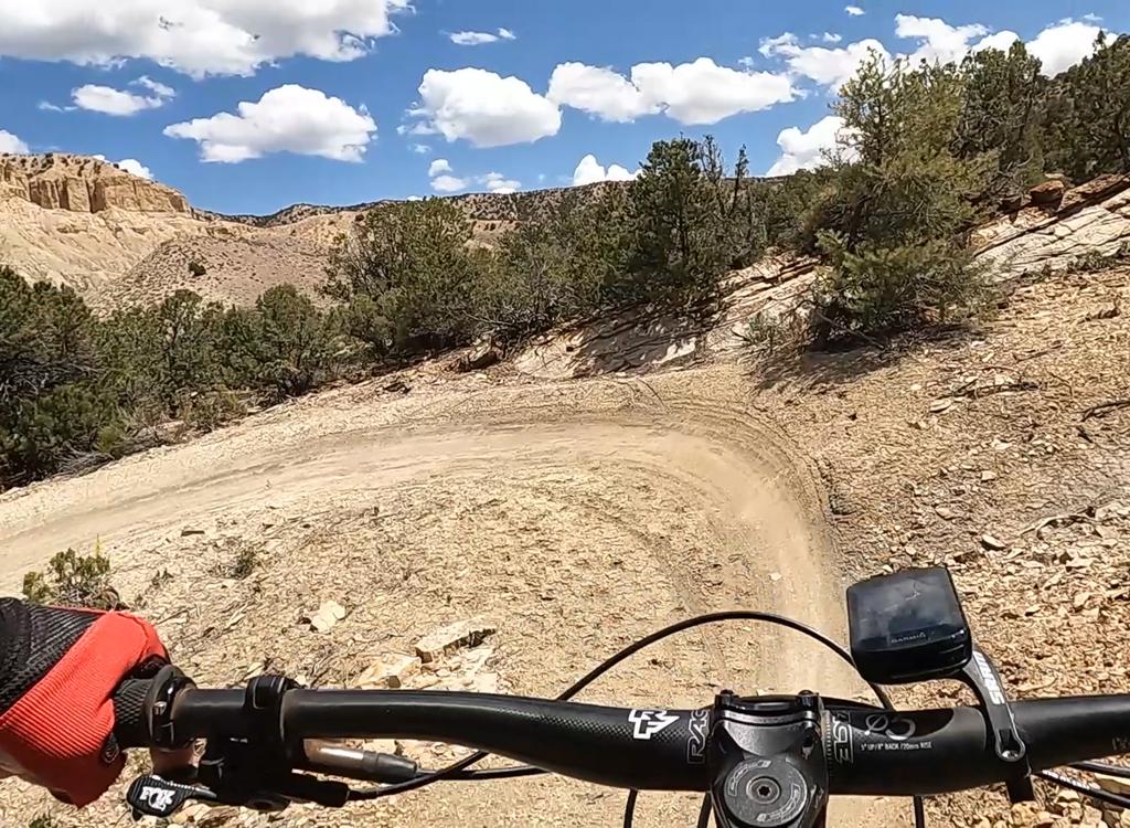
We're about a mile into the ride, heading up and over the first hill, looking south. The cliffs are Wingate sandstone; the skirts are Chinle.

From the top of the first climb, we pause to look southeast to the La Sal Mountains, with Highway 191 following the Moab fault line down towards the Colorado.
There's one section of steep loose rocky dirt above the Gold Bar turnoff. Even the toughest
bikers will walk up this one. (When you get back to this section going
downhill, riders who
aren't experienced "sand surfers" should walk down also.)
Option: Shuttle from the top!
Many riders -- particularly those with less leg power or "early season endurance" will want to consider a shuttle ride. Drop-off is at the top of the Gemini Bridges Road where it leaves Highway 313 (13 miles from 191). It's all downhill until you hit the little hill near the end, where you'll do about 300 vertical to get up and over to reach Highway 191. From here, you can coast all the way back to Moab via the paved Old 191 bike path.
Many riders -- particularly those with less leg power or "early season endurance" will want to consider a shuttle ride. Drop-off is at the top of the Gemini Bridges Road where it leaves Highway 313 (13 miles from 191). It's all downhill until you hit the little hill near the end, where you'll do about 300 vertical to get up and over to reach Highway 191. From here, you can coast all the way back to Moab via the paved Old 191 bike path.

Matt, Dominic, and Mike cruise the road near the "Gooney Bird." The sheer cliffs are of Wingate Sandstone. The ledge near the valley floor is the Chinle formation. These formations date to the late Triassic to early Jurassic Era, 200 to 170 million years ago.

Bruce rides old Banana Thunder. There are constant views as you head uphill.
For those with some time and leg power, you can pedal to the top of 313. Leave Moab on
Old 191
and go to its end on 313 (8 miles), pedal uphill through beautiful rock formations to the top
of Gemini Bridges road (13 miles). Do the ride (16 miles). Now coast back
to Moab on Old 191
(7 miles). Total 44 miles, but not too tough.
The trail is a broad rocky dirt and gravel road, with some steep sections and some slickrock.
The route is well-marked. At each fork, a sign shows you the right way.
It's a "four-wheel
drive" road, but well-maintained and graded frequently. It may be muddy
after rains. If you
decide to drive in, the upper road from 313 is smoother and easier to
drive than the lower
half from 191.
As you approach the bridges, the road forks into a small loop. There are a couple of viewpoints, then a 1/4 mile hiking trail that takes you to the arches. GPS N 38° 35.123' W 109° 42.456'. A bike rack is provided for cycle parking.

Looking at the arches from one of the viewpoints as you approach the parking area.

Dominic rolls down an area where the road is on open rock. That's about as "technical" as this ride gets.
The downhill run is fast. If you've got time and leg power, you can consider scenic side trips
into
Bull Canyon
or around
Two Tortoise
Rock
If you're up to a little singletrack, consider
Arth's
Corner
,
Great Escape
, and
Little Canyon ST
as alternatives to descending the Gemini Bridges road. These trails can be done by good beginning
riders.
Getting there: Drive north from Moab on US
191 about 7 miles north of the Colorado River (22
miles south
of I-70). Spot the parking area on the west (right as you
head toward Moab) side of the road. GPS N 38° 39.381' W 109° 40.672'. Park in front of
the railroad tracks, and head out west on the road. As of 2009, a $5 fee is
required to park here (it's private land). But you can park across the
road at the Bar M lot and ride back.
By bike from Moab: Pedal 7 miles up the Old 191 bike path. For the out-and-back, turn off at the Gemini Bridges road. For a big loop, go another mile up Old 191 then 13 miles on highway 313 to the top of Gemini Bridges.
By bike from Moab: Pedal 7 miles up the Old 191 bike path. For the out-and-back, turn off at the Gemini Bridges road. For a big loop, go another mile up Old 191 then 13 miles on highway 313 to the top of Gemini Bridges.
Bathrooms: Trailhead
Water: None
Camping: Primitive, in designated sites along Gemini Bridges road

Simplified map of Gemini Bridges road.
Riding Resources for Gemini Bridges:
Single-page riding guide for printing
Topo map: Low Res High Res
Lodging, camping, shops: Links to Moab area resources
Single-page riding guide for printing
Topo map: Low Res High Res
Lodging, camping, shops: Links to Moab area resources
GPS track files (right-click and "Save as..."):
Gemini alone
GPX Gemini / Two Tortoise / Bull Canyon
Master file of area tracks
Gemini alone
GPX Gemini / Two Tortoise / Bull Canyon
Master file of area tracks