The Flying Dog trail is a fun trail that arcs between the middle of 24-7 over to the top of the Cobblestone Loop above Glenwild . In other words, you need to climb another trail to get to it. This is one of the best trails in the area. If you're going to do anything in the Jeremy Ranch area, you need to do this one.
The trail instructions below include the 10-mile easier ride, a 16-mile moderate ride, and a tough 23-mile grinfest with 3000 feet of climbing. And you can add a dip down the Bobs Basin DH trails while you're passing by. There are a lot of great options here.


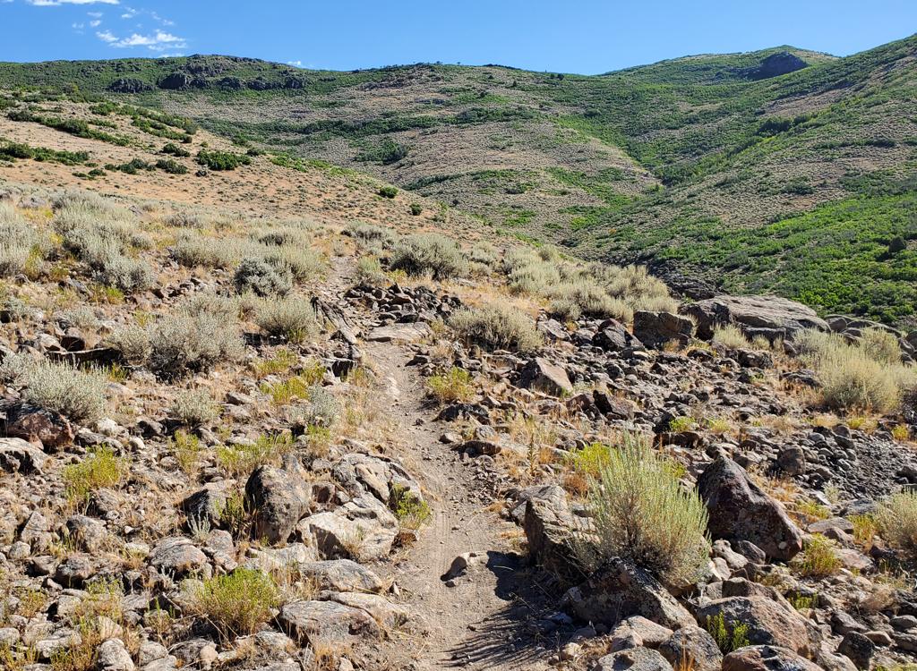
As the trail climbs, the oak gets bigger, then a few maples join in. As you climb higher and hit the north-facing slopes, you enter aspen forest, with a fir here and there. Throughout the ride, there's an assortment of open brush slopes, meadows, views, and forest.


A much-overlooked option is to start by climbing Graduate and Fink Again, then proceed to Flying Dog. After whatever short or long ride you chose to do, head down one of the DH freeride trails. If you've got anything left, keep circling back up until you've gotten your fill. Ant Farm, Team Cutthroat, and Dropout are great downhill-only routes with a lot of fun stuff. (These trails are described on the Jeremy Ranch 24-7 trail page .) But you don't need to be an expert to ride them. Just go around the stuff that scares you.
Jeremy Ranch 24-7: Just after Parley's Summit, take the Jeremy Ranch exit and turn north (left) under the freeway. Turn left at the first stop sign, then take the next right (Jeremy Ranch Drive). Continue until the road turns sharply around to the right, where you'll see the dirt East Canyon Road branching off to the left. Park and climb the ST on the east side of the road (the direction your car was facing as you came around the paved turn).

Jeremy Ranch, Graduate trailhead: At the I-80 Park City exit, go north (left from the exit if you're coming from SLC) to the frontage road. Turn left on the frontage road. Next turn left again toward the school. As you pass the school, there's parking on the left. Just past the school, there's a fenced area with a shed on the right, and a gravel roadway on the far side. About 100 yards down this gravel path, at the end of a broad gravel area (don't park here), there's a wooden bridge. That's your trail. At the first fork, keep R. At the 2nd fork (Fink Again), go L.

Jeremy-Preserve Flying Dog Loop, counterclockwise
1500 vertical feet, 10 miles, tread=intermediate
0.0 24-7 Trailhead, East Canyon Road Jeremy Ranch
N40 46.150 W111 35.033
2.0 L uphill on Flying Dog
N40 45.845 W111 33.142
2.5 R on Preserve Connector
N40 45.841 W111 33.046
3.5 L on DT then straight N uphill on road
N40 45.870 W111 32.566
3.8 R at road fork
N40 46.080 W111 32.671
N40 46.118 W111 32.639
4.5 L uphill on Flying Dog
N40 46.337 W111 32.013
5.1 Cross road
N40 46.402 W111 32.475
7.7 Viewpoint uphill 100 yds
N40 46.304 W111 33.087
8.4 Back at Preserve junction, fork R downhill
N40 45.841 W111 33.046
8.9 Fork R on 24-7
N40 45.845 W111 33.142
10.9 Back at trailhead
Flying Dog with Lower Glenwild
0.0 Glenwild TH, toward mountain on road
N40 43.681 W111 32.178
Cross bridge, L on Stealth ST
N40 43.714 W111 32.206
0.3 Ignore trail forking R uphill
N40 43.849 W111 32.517
1.8 Left on Stealth/24-7
N40 44.478 W111 32.941
2.1 R (L=Dropout DH trail)
N40 44.638 W111 33.124
2.2 R (L=Cutthroat, 2nd L = Ant Farm)
N40 44.690 W111 33.066
2.8 R (L=Fink Again)
N40 45.044 W111 33.087
3.5 Cross paved road
N40 45.325 W111 33.053
4.3 Keep R (L=bailout to JR)
N40 45.675 W111 33.101
N40 45.845 W111 33.142
4.9 L on Flying Dog
N40 45.841 W111 33.046
5.6 R=Viewpoint 100 yards
N40 46.304 W111 33.087
8.9 Keep L (R = Preserve Connector)
N40 46.337 W111 32.013
10.2 Cross paved road N40 46.035 W111 31.789
10.5 Cross paved road N40 45.799 W111 31.627
10.7 Cobblestone loop, fork L
N40 45.704 W111 31.573
11.4 Exit loop, fork L downhill
N40 45.365 W111 31.750
12.3 Fork R on Glenwild
N40 44.756 W111 31.279
14.9 L downhill
N40 43.928 W111 31.965
16.1 Back at parking
Flying Dog w Stealth and Glenwild
0.0 Glenwild TH, toward mountain on road
N40 43.681 W111 32.178
Cross bridge, L on Stealth ST
N40 43.714 W111 32.206
0.3 Ignore trail forking R uphill
N40 43.849 W111 32.517
1.8 Left on Stealth/24-7
N40 44.478 W111 32.941
2.1 R (L=Dropout DH trail)
N40 44.638 W111 33.124
2.2 R (L=Cutthroat, 2nd L = Ant Farm)
N40 44.690 W111 33.066
2.8 R (L=Fink Again)
N40 45.044 W111 33.087
3.5 Cross paved road
N40 45.325 W111 33.053
4.3 Keep R (L=bailout to JR)
N40 45.675 W111 33.101
4.4 Keep R uphill
N40 45.788 W111 33.171
4.5 R uphill on Flying Dog
N40 45.845 W111 33.142
4.9 R on Preserve Connector
N40 45.841 W111 33.046
5.9 L on DT then straight N uphill on road
N40 45.870 W111 32.566
6.2 R at road fork
N40 46.080 W111 32.671
N40 46.118 W111 32.639
6.9 L uphill on Flying Dog
N40 46.337 W111 32.013
7.5 Cross road
N40 46.402 W111 32.475
10.2 Viewpoint uphill 100 yds
N40 46.304 W111 33.087
12.9 Back at Preserve junction, fork L uphill
N40 45.841 W111 33.046
Retrace route through Preserve Connector
14.9 Flying Dog, L downhill
N40 46.337 W111 32.013
16.2 Cross paved road N40 46.035 W111 31.789
16.5 Cross paved road N40 45.799 W111 31.627
16.7 Cobblestone loop, fork L
N40 45.704 W111 31.573
17.4 Exit loop, fork L downhill
N40 45.365 W111 31.750
18.3 Fork R on Glenwild
N40 44.756 W111 31.279
18.9 Cross paved road N40 44.749 W111 31.936
20 Top of hill, cross road
N40 44.470 W111 32.360
20.5 Fork R DH on DT (across=Glenwild)
N40 44.375 W111 32.483
21.1 L on Stealth
N40 44.478 W111 32.941
23 Back at parking
Single-page riding guides:
Short&Sweet Lapdog Loop
Big Dog Loop
The Big Pretzel (Dog-eat-dog)
GPS track files (right-click and "Save as..."): Flying Dog only
Loop Ride "Big Dog"
GPX area tracks
Large-format topo map (600K): View
Lodging, camping, shops: Links to Park City area resources