Matt Flygare and Mike Engberson pause to look over the sandstone cliffs of Flat Pass. The most sheer cliffs of the Moab area are formed of Wingate Sandstone. Photos and ride review October 20, 2000 by Bruce Argyle.
Flat Pass Trail
The Flat Pass Trail is an advanced technical ride with some similarities to the Porcupine Rim Trail. Ridden south-to-north, there's an initial 1000 feet climb over 4 miles, then 1500 feet of descent over 6 miles.
Flat Pass can be ridden as a 10-mile point-to-point with a shuttle, or a 19-mile loop (with
the return on paved road). The 10-mile version is strenuous; the 19-mile
loop is a killer.
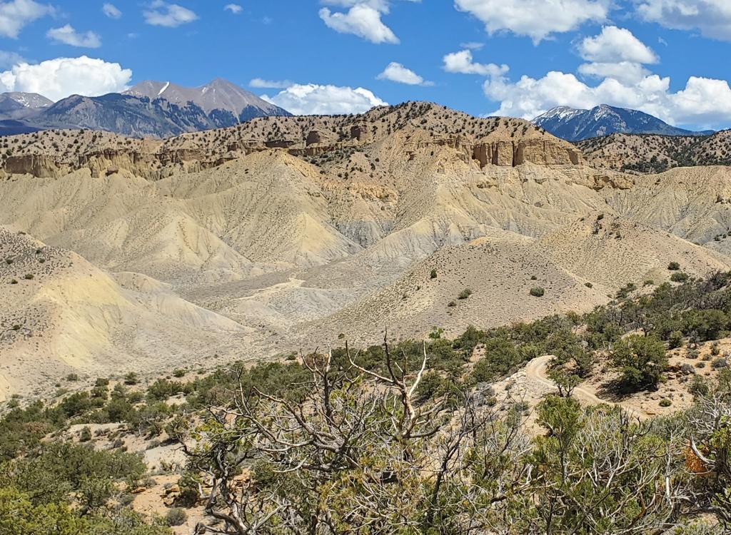
, Dominic Bria, and Mike climb a section of rock. The g...")
Matt (nearest the camera), Dominic Bria, and Mike climb a section of rock. The guys roll up a ledge of Kayenta sandstone underlying the domes and fins of multi-colored Navajo Sandstone. Entrada sandstone is on the skyline.

Mike works his way a series of rock ledges. October 20, 2000.
Most riders ride point-to-point, starting at the summit cattleguard at Flat Pass. From there,
it's a quick downhill to a fork in the road, where you'll turn right.
(Trail intersections
have signs.) A quick dip through a rather deep creek, and you're climbing
up the rocky ledges.
For about two miles near the top of the climb, the rock is rough, with enough advanced technical
ledges to practice your stunts. Five miles into the ride, on the descending
side of the mountain,
the trail smooths out a little.

Chad tackles a technical ledge.

View toward the cliffs showing a typical trail section. For most of the ride, you'll share the trail with motorcycles and 4 wheelers.
Once you begin the descent, you'll encounter a few branching roads. Just follow the sign that
says "Flat Pass." If you're ever in doubt, go left.
The trail drops down into the canyon along Mill Creek. Once you reach the creek, it's a gradual
descent through a beautiful deep sandstone canyon. This section has spots
with deep sand, but
every inch is rideable. You'll dip through the creek three times, then
turn to climb up over
the ridge to the northern trailhead.

Bruce cruises along the final section of trail near Mill Creek.

Flat Pass map
Getting there, northern trailhead:
To ride the trail point-to-point, leave a shuttle car at the northern trailhead. To get there, travel south from Moab's Center Street 4 miles. Watch for a gas/convenience store at a "T" intersection on your left. Turn left (east) here. A couple of blocks later, this road becomes Spanish Trail Road. Continue until it becomes Canyonlands (for about 100 yards). At the next intersection, turn right (east) on Westwater. Follow Westwater up to the top of the hill, where you'll see a trail sign on the right and a parking area on the left. It's two miles from the highway to the trailhead.
To ride the trail point-to-point, leave a shuttle car at the northern trailhead. To get there, travel south from Moab's Center Street 4 miles. Watch for a gas/convenience store at a "T" intersection on your left. Turn left (east) here. A couple of blocks later, this road becomes Spanish Trail Road. Continue until it becomes Canyonlands (for about 100 yards). At the next intersection, turn right (east) on Westwater. Follow Westwater up to the top of the hill, where you'll see a trail sign on the right and a parking area on the left. It's two miles from the highway to the trailhead.
Southern trailhead:
To get to the southern trailhead, drive back to US-191 and go south about 4 miles (you're now 8 miles south of Moab). Watch for a road on your left for Ken's Lake and La Sal Loop Road. Drive 0.5 miles, then turn right. Keep left at the next two intersections, following the signs for Ken's Lake. When the paved road veers left, keep straight (see the road going up the hill?). For point-to-point, drive on up to the hilltop, and park on the left in front of the cattleguard. For a loop, don't climb the hill. Instead, turn right into the camping area at the bottom of the wash and park there.
To get to the southern trailhead, drive back to US-191 and go south about 4 miles (you're now 8 miles south of Moab). Watch for a road on your left for Ken's Lake and La Sal Loop Road. Drive 0.5 miles, then turn right. Keep left at the next two intersections, following the signs for Ken's Lake. When the paved road veers left, keep straight (see the road going up the hill?). For point-to-point, drive on up to the hilltop, and park on the left in front of the cattleguard. For a loop, don't climb the hill. Instead, turn right into the camping area at the bottom of the wash and park there.
Riding resources for this trail:
Single-page riding guide
GPS track files and route (right-click and "Save as..."): GPX
Low-res topo map (100 KB): view
High-res topo map (1 MB): view
Lodging, camping, shops: Links to Moab area resources
Single-page riding guide
GPS track files and route (right-click and "Save as..."): GPX
Low-res topo map (100 KB): view
High-res topo map (1 MB): view
Lodging, camping, shops: Links to Moab area resources