
Overview Page
This shuttled ride includes the trails Geyser Pass, Burro Pass, Hazard County, a piece of Kokopelli (or Jimmy Keen ), Porcupine Singletrack, and Porcupine Rim in an epic La Sal to Colorado ride
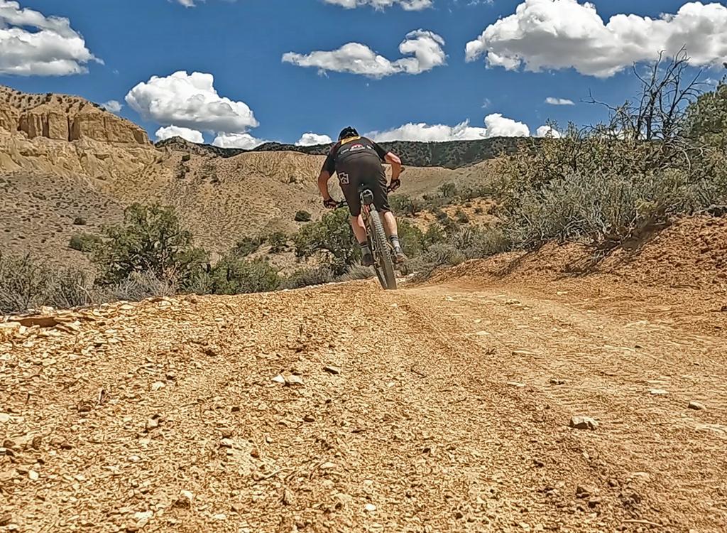
This ride is 28 miles long, with 7000 vertical feet of downhill. It's an unforgettable epic experience, but is only for strong, skilled, and adventuresome riders. It peaks at 11,200 feet in the La Sal Mountains and drops to the Colorado River. Climbing will total about 2200 feet.
The Geyser Pass Singletrack is a newer segment of the Whole Enchilada, proving a nice plush singletrack route from parking at Geyser Pass to the Burro Pass trailhead. This segment is 1.5 miles long, with 150 vertical feet of climbing. But you'll actually lose a total of 200 vertical feet between Geyser Pass and the Burro Pass trailhead, going from 10,500 to 10,300.


You'll quickly come to a fork in the dirt road 0.1 miles from the trailhead. The right fork is FR 071 heading east, with a connection uphill to the Burro Pass trailhead. This is the old route. Instead, keep left on FR 243. The fork in the road is marked with a nice sign (as of 2015). Just uphill along the side of the left fork, you'll also see the little "WE" sign that marks the Whole Enchilada route.
After a mile, the trail will begin to drop into the little canyon south of Burro Pass. When you reach a doubletrack heading straight uphill, turn left and climb. The Burro Pass trailhead will be on your right, about 200 feet uphill.

Begin from Geyser Pass parking
0.0 ST between toilet and kiosk
N38 29.122 W109 13.940
0.05 L on ST N38 29.163 W109 13.932
0.1 L at DT fork N38 29.197 W109 13.913
0.15 R on Geyser Pass ST
N38 29.228 W109 13.930
1.5 Left uphill on Burro DT
N38 29.756 W109 13.056
1.55 Burro Pass trailhead
N38 29.801 W109 13.036
Keep straight and uphill
...proceed to Burro Pass segment
Most riders will already have started from the Geyser Pass trailhead. (The official Burro Pass trailhead is remote and may not be drivable after a rain or in early summer, with the last 1/2 mile very steep and rutted.)
From the official trailhead at 10,400 feet, you'll ride uphill 800 vertical feet in 1.2 miles. Unless you're superhuman, there will be some hike-a-bike sections. (20% slope at 11,000 feet is tough!) Enjoy the beauty. Later on, you'll be too busy flying downhill and trying not to crash.
Crossing the ridge, you begin a steep switchback descent. This is fun stuff, with some technical challenges involving loose rock, roots, and very tight switchback turns.

As you reach the aspen zone, you may actually have to pedal a bit. When you reach a water-diversion ditch, you're almost done with Burro. We took the trail over the ditch and uphill across a small mountain. It looks like you can ride along the ditch and meet the trail later near Warner Lake.
At the 4-way intersection, keep right, go through a squeeze gate and past a small lake. At the back of the Warner Campground, you've finished the Burro Pass section....you are at the Burro Pass trailhead
1.5 Start uphill through the trees
N38 29.801 W109 13.034
Step through the gate onto ST
2.7 Ridge, cross and start downhill
N38 30.214 W109 13.654
Switchbacks, loose, steep
4.7 Fork L downhill
N38 30.701 W109 15.143
N38 30.53 W109 15.68 (approx)
6.3 Fork R, go through squeeze gate
N38 30.989 W109 16.437
Pass by lake
6.5 DT Warner Campground
N38 31.161 W109 16.519
Follow main road out of CG
...Proceed to Hazard County
Head out of the Warner Campground on gravel road. Descend a bit, then when the trail starts uphill, fork right on gravel road to the Hazard trailhead. Start uphill on singletrack. You'll make a fairly stiff climb of about 1/2 mile.
At the crest of the hill, you enter a zone of armored gap-jumps. Do them if you dare. There's a big penalty if you don't clear the gap! You leave aspen and enter a gambel oak area, like an uber-Lambert Park.

Begin Hazard County Section
7.0 As road starts uphill, fork R uphill
N38 31.460 W109 16.806
7.1 Hazard County TH on R of parking
N38 31.532 W109 16.907
Up hill, then long twisting descent
10.4 Meet La Sal Loop Road
N38 32.545 W109 18.736
...Proceed to Kokopelli


The Kokopelli starts as a dirt doubletrack surrounded by grass and oak brush, right across the road from Hazard. At first, it's a gentle downhill slope, with a bit of occasional uphill. The terrain becomes dryer, giving way to rocky jeep road surrounded by pinion and bitterbrush.
Begin Kokopelli Section
Cross La Sal Road onto DT
11.9 Through fence over hiking cattleguard
12.0 Upper Porcupine Singletrack forks R
N38 33.706 W109 19.649
Fork R for UPS option, L for Kokopelli Options

Fork R on UPS at mile 12
14.0 Overlook at DT, cross to ST
N38 34.529 W109 20.767
15.0 R at ST fork (L=Sand Flats Rd)
N38 34.842 W109 21.453
All options now converge on same ST fork. See below
Stay on Kokopelli at 12.0
13.4 Sand Flats Rd, fork R uphill
N38 33.880 W109 21.114
14.4 Fork R on DT
N38 34.428 W109 21.351
15.0 At overlook, find ST on L
N38 34.529 W109 20.767
16 R at ST fork (Add 1 m to distance)
Porcupine Singletrack
N38 34.842 W109 21.453
14.4 Stay L on Sand Flats Road
N38 34.428 W109 21.351
14.8 Cross cattleguard, R on ST
N38 34.709 W109 21.510
15.0 L at ST fork onto LPS
Porcupine Singletrack
N38 34.842 W109 21.453

Jimmy Keen is a singletrack trail finished by the National Forest Service in late fall 2014. It's an excellent alternative to riding Kokopelli, connecting you from Hazard County to the Upper Porcupine Singletrack. The trail takes a large meander out through Jimmy Keen Flat. You'll do some climbing on this trail, and its meandering course will add significantly to your time and miles. At almost 8 miles, it's over four times as long as the straight shot down Kokopelli.
You can reach Jimmy Keen either from the viewpoint on the La Sal Loop road just north (to your right) as you finish Hazard County, or you can pedal down Kokopelli to the point where the trail crosses.

The porcupine Singletrack stretches from the mid-Kokopelli down to the Castle Valley overlook on the Porcupine Rim trail. It's divided into Upper and Lower Sections. This is IMHO the best part of the ride. Quick moves on singletrack through pinion forest with patches of slickrock. Lots of dropoffs.
The second connector from Sand Flats Road to the Porcupine Singletrack is 2-1/2 miles from Kokopelli. As you ride the straight section of Sand Flats, cross a cattleguard and spot a singletrack on the right (going north). Follow this about 1/2 mile to a T intersection and turn left.


Lower Portion, Porcupine Singletrack
15.0 From ST fork proceed northwest
(L if coming from cattleguard, R if already on LPS)
Hike down Big Dip
16.8 At Porcupine Rim overlook
N38 35.656 W109 22.637
...Go right on Porcupine Rim DT
The Porcupine Rim section begins at the Castle Valley overlook. This is about 4 miles from the start of the Porcupine Rim ride, and skips almost all of the climbing. Head right and follow the Porcupine Rim trail DT, slightly uphill as it parallels the rim.


Begin Porcupine Rim Section
Castle Valley overlook
West (right) on DT
Follow Porcupine Rim down
28.0 At highway

Single-page riding guide
GPS track files (right-click and "Save as..."):
Multi-track GPX file (see individual pages for single trails)
Whole Enchilada continuous track
Medium-res topo (1.5 MB): View
High-res topos: Burro Pass Hazard Kokopelli-UPS area Porcupine Rim
Lodging, camping, shops: Links to Moab area resources