Bruce enjoys the rough sandstone of EKG. Photos and ride description November 2, 2011 by Bruce. Latest update May 2018.
The EKG Trail is an expert-level tech trail, but can be managed by strong intermediates. To
get to the trail, you need to ride portions of other trails, so the minimum
ride will be 11
miles (Mega Steps trailhead). The trail can be done either direction.
I think it flows a little
smoother in the north-to-south direction -- but I suggest you do it both
ways and decide for
yourself.

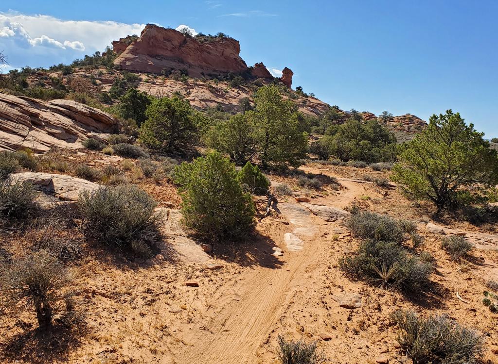
The slope tilts downhill to the west. The skirts of the mesas are the Brushy Basin member of the Morrison Formation, while we're riding on the layer below it -- the Salt Wash sandstone. Dino tracks are extra credit. This is the era of the allosaurus and long-necked sauropods.

The trail has turned through a wash and is now heading straight up the slope again. You will spend a little time riding "across" but most of the time you're going uphill or downhill.
Almost all of the eastern Klondike trails connect to EKG somewhere. At
the south end, the
Dino Flow
singletrack takes
you to EKG 0.2 miles from the Klondike road. Fork right as EKG leaves
Dino Flow.
Northbound on EKG 0.2 miles from where EKG forked uphill away from Dino Flow,
there's a 1.9-mile loop
called
Miner's Loop
that forks off to the
east. After another 0.8 miles, EKG meets Dino Flow again. (If
northbound, keep right and uphill to stay on
EKG.)
At mile 1.6 from the Copper Ridge Road, EKG crosses
Baby Steps
South. Next you'll cross
Little
Salty
, then Baby Steps North before EKG ends as it hits the junction
with
Mega
Steps
and
Alaska
.
You won't have to spend time scouting the trail and trying to find your way. The trail is well-marked
with orange paint stripes on the rock. Many sections also have trailside
logs and rocks to
make the riding line obvious. "Helper rocks" are strategically placed
under the bigger ledges
to smooth things out for intermediate riders.

The trail makes a dozen trips up and back down the slope, going through the bottom of a wash, then climbing up around the top of the next wash.

Riding two days after a snowstorm. The runoff is over but there's still water in the washes. If you look closely, you can see snow in the shadow of the rock on the right.
The general course of the trail traverses a tilted layer of sandstone. From north to south,
it's only 50 feet of absolute elevation change (average 4800 feet). But
the trail does NOT
make a straight traverse. It's constantly going uphill, then downhill,
as it navigates the
many arroyos that gouge the rock. The up-and-down riding will add up to
around 1500 vertical
feet -- depending on how often your GPS unit marks the altitude.
The up-and-down pattern of the trail is why it's called the "EKG" trail. Yes, it does make
your heart pitter-patter with excitement. But the name EKG is based on
the shape of the trail.
It looks like a particularly nasty case of ventricular fibrillation. (Not
that there's any
"good" v-fib.)

Here the trail is crossing Little Salty. Little Salty is marked with yellow paint, while EKG is orange. The trail intersections are clearly marked, with signs showing where you are on the trail system. Well done!

We've pedaled up and around the head of an arroyo. Now we're headed straight down the slope. We'll be going through the bottom of the next wash after it opens up. Then it will be back uphill again! But the climbs are short enough that I never tired.
The course of the trail swings regularly uphill and downhill, and the riding line goes up and
down as you roll over ledges and humps of rock. According to my GPS, this
"50 feet of elevation
change" trail had a total of over 1000 vertical feet of climbing -- each
way.
So you'll head straight downhill to hit a wash crossing where it opens up. Then you'll turn
and head straight uphill to go around the uphill head of the next wash.
Your riding time for this trail will depend on your appetite for tech challenges, and on the
time you spend shooting photos, talking, and watching other riders. Allow
about 90 minutes
for your first time (just for the EKG portion of your ride). But if you're
in a hurry, well,
I rode north-to-south in 41 minutes and I wasn't pushing it.

Following the orange brick road uphill.
. It ta...")
A spot I struggle with. It's an easy roll downhill (riding south to north). It takes me a few tries to get uphill (north to south trip). Something about the crack between the 3rd and 4th rock.
Some riders aren't up to a huge ride, but still want to test themselves on the rock. I suggest
you pick one section of EKG. Then take either Dino Flow or Copper Ridge
Road to the connecting
trail. Climb uphill to EKG (usually less than 1/4 mile uphill). Do your
section of EKG, then
bail downhill at the next trail that crosses EKG. These trails all go
to Dino Flow, then further
down to the easy Copper Ridge doubletrack.
Options for tough or long rides? Many! For example, you climb south Baby Steps to UFO, link
to Mega Steps then Alaska. Riding counterclockwise, you then arrive at
the north end of EKG
and head south.
Or consider a figure-eight. Ride EKG one direction, loop around on the upper mountain with
Alaska to Baby Steps, ride EKG the other direction, then loop back via
Dino Flow. A bit over
20 miles. Delicious!

Behind this tree is an off-camber steep uphill spot. Get some speed by swinging wide, following the orange stripes. If you chicken out, hike up and around (mid-left in the photo) -- the side-slope has too much pitch to hold bike shoes very well.

We're at the Baby Steps North crossing, southbound. Baby Steps North is marked in baby blue paint.
Most riders will want to ride the simple loop of EKG outbound and Dino Flow back. Easy to navigate,
and for most riders, just enough. Depending on where you start (Dino Tracks,
Mega Steps, south
Klondike) it will be a bit over 11 miles. That's the ride shown in the
video below.
Bottom Line!
EKG is one of my favorite Moab trails. Because it connects to Dino Flow, Miner's Loop, Baby
Steps South, Little Salty, Baby Steps North, Alaska, and Mega Steps, it
can be part of many
different ride combinations. Ride a little of it, or a lot of it. Or ride
it twice. It's worth
it.

We've reached Mega Steps and the end of EKG. Mega Steps is marked light green. From this spot, Alaska continues north.
Riding guide, Copper Ridge to EKG loop:
0.0 East across cattle guard
N38 46.417 W109 42.735
0.8 Veer L on Copper Ridge Rd
N38 46.997 W109 43.072
1.7 Straight (R = Baby Steps)
N38 47.545 W109 43.603
2.6 Straight (R = Little Salty)
N38 48.184 W109 44.194
3.6 Straight (R = Baby Steps North)
N38 48.810 W109 44.847
4.4 R on Mega Steps
N38 49.196 W109 45.404
4.8 R on EKG Trail
N38 49.420 W109 45.029
5.8 Baby Steps joins from the
left
Veer L (southeast) to stay
on
EKG
N38 48.964 W109 44.611
7.2 Straight (cross Little Salty)
N38 48.591 W109 43.916
8.9 R downhill on Baby Steps
(Option 2012: straight on new
EKG section)
N38 47.750 W109 43.292
9.3 L on Copper Ridge Rd
N38 47.546 W109 43.604
10.2 R (L=Klondike Bluffs)
N38 46.982 W109 43.070
11.0 Back at parking
EKG both ways!
w Mega Steps up and Little Salty down:
0.0 East across cattle guard
N38 46.417 W109 42.735
0.8 Veer L on Copper Ridge Rd
N38 46.997 W109 43.072
1.7 R to Baby Steps South
N38 47.545 W109 43.603
2.1 L onto EKG
N38 47.742 W109 43.284
3.8 Cross Little Salty, keep straight
N38 48.598 W109 43.912
5.2 R uphill joining Baby Steps North
100 ft then veer L to stay
on
EKG
N38 48.960 W109 44.614
6.2 R uphill on Mega Steps
N38 49.420 W109 45.034
7.8 Top of ridge, veer south
8.9 Reach DT N38 49.480 W109 43.799
Keep straight on Baby Steps
southbound
10.3 Fork R on Little Salty
N38 49.129 W109 43.379
11.3 Cross EKG, keep straight
N38 48.598 W109 43.912
12.0 R on Copper Ridge DT
N38 48.179 W109 44.193
13.0 Keep straight (R = Baby Steps N)
N38 48.802 W109 44.840
13.8 R uphill on Mega Steps
N38 49.196 W109 45.404
14.2 R on EKG
N38 49.420 W109 45.034
15.2 Cross Baby Steps, stay on EKG
N38 48.960 W109 44.614
16.6 Cross Little Salty, stay on EKG
N38 48.598 W109 43.912
18.3 R downhill on Baby Steps South
N38 47.742 W109 43.284
18.7 L on Copper Ridge Rd
N38 47.545 W109 43.603
19.7 Fork R (L = Klondike)
N38 46.997 W109 43.072
20.4 Back at parking

Klondike area map.
Getting there, southern Klondike Trailhead: Starting at the Colorado River, drive
15 miles north from Moab. Look for a turnout with parking on the right and
a sign for Klondike Bluffs Road. There will
usually be cars parked there (
GPS N 38° 44.452' W 109°
44.037'). For a longer ride, park here and ride up the road. Most cyclists will choose to go through the gate and drive 2.7 miles. Keep left at
the fork. At 2.8 miles, park your car in the broad parking area by the
fence. Go eastbound across the cattleguard through the fence and begin your ride.
When you reach the fork in the Klondike road, take Dino Flow to EKG.
Note: Map color-coded to show named trails individually.
Does not correspond to described loops above.
Northern Klondike Trailheads: On Highway 191 8.5 miles
south of I-70 and 6.5 miles north of the southern Klondike Bluffs road
(about 5 miles north of the airport), watch for a "Northern
Klondike" sign at N38 49.504 W109 46.893. Turn east (toward the
sandstone bluff). Keep to the right as the road winds south around a small
hill.
Chilkoot TH: 1.2 miles from the highway as the road is heading east toward the
bluff, the
Chilkoot trailhead is on your right.
Agate TH: Go a bit past the fenced parking area then fork right on a fainter jeep road
at N38 49.103 W109 46.061. (The
main road continues to the dinosaur tracks, with an alternate trailhead
here for the Dino Flow trail.) At mile 1.6 from the highway, you'll come to the TH for the
Jasper and Agate
loops (N38 49.087 W109 45.625) on your right.
Mega Steps TH: Continuing past the Agate TH, at 2.0 miles you're at the
bottom of
Mega Steps at a larger parking area N38 49.179 W109 45.417.
Take Mega Steps uphill to reach EKG's northern end.
Dinosaur Tracks TH: At the trail fork at mile 1.2, keep left
on the main road toward the dinosaur tracks. About 1/2 mile further, turn
to the right into the parking area. The
Dino Flow trail is up against the
mountain, to the left of the pit toilet.


. It ta...")