

View of the cliffs above the western end of the trail. Photos by Bruce, April 17, 2009, with help from faithful trail dog Jackie. Updated November 2017.
Dino Cliffs Trail
Connections to Church Rocks and Prospector
The Dino Cliffs Trail is a singletrack route along the low red cliffs just north of Washington. The trail itself is short (1.8 miles), but you must ride dirt road to get there. The ride is 4.3 miles as a loop and about the same as an out-and-back.
Connections to Church Rocks and Prospector
The Dino Cliffs Trail is a singletrack route along the low red cliffs just north of Washington. The trail itself is short (1.8 miles), but you must ride dirt road to get there. The ride is 4.3 miles as a loop and about the same as an out-and-back.
Perhaps more important to riders in St.George, the trail provides a fun dirt-and-rock route
from city streets to the Church Rocks Loop and the Prospector Trail. You
can leave your house
or motel on bicycle and ride all the way to Silver Reef.
. The beginning of Dino Cliffs is ...")
View along the Grapevine Trail (really a road). The beginning of Dino Cliffs is right in the middle of the photo, where the rock edge meets the roadway. The corner in the road at mid-right is where the connector to Church Rocks and Prospector forks off.

There are small ledges here and there. Downhill, you can roll 'em or huck 'em. When riding uphill, some ledges require strength and skill to clean.
Total climbing is around 300 feet, with lowest altitude 3000 feet. The ride is intermediate
technical with a few short advanced spots. But most of the eastern end
is easy and suitable
for beginners with a few step-overs. The easiest access is right off the
new Washington Parkway
I-15 exit.
First, let's talk about beginners. From the Grapevine trailhead, you can ride an easy mile
of dirt road (see photo), then fork left to head west on Dino Cliffs.
Ride south until you
start to hit stuff that makes you nervous (or walk through the tricky
spots), then head back.
The first 0.6 miles of Dino Cliffs is about the easiest slickrock you'll
ever ride. Nice 3.2-mile
out-and-back with the kids.

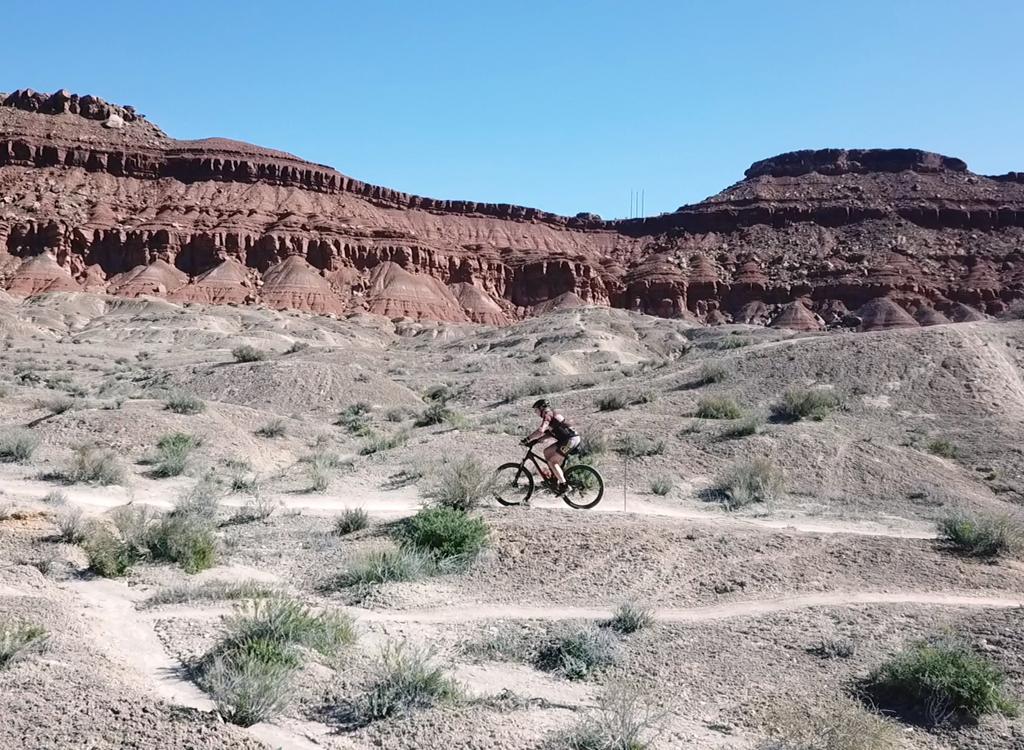
The trail flows over smooth Navajo sandstone, with views south of Washington and the surrounding hills and mesas. To the north are views of the tall volcanic Pine Valley Mountains.

Looking north from the valley as I ride along the cliff edge.
The loop ride I describe below is a counter-clockwise trip including Grapevine, Dino Cliffs,
and a dirt road return. (Some of the dirt-road area is plumbed with sewer
for future development,
so let me know when I need to update my ride plan!)
The official Dino Cliffs Trail has 0.1 mile of steep deep sand at the west end. I use the official
route in my ride description, but here's the thing: I didn't see a single
tire-print on that
section. Seems most people were heading up/down the wash that's at the
bottom of that long
sandy hill. I haven't included that option in my map or track file since
it's not a sanctioned
route.

View of typical trail section on the eastern third - easy riding!

Looking east, we're riding below the cliff edge, as the trail winds up and down in rock and dirt.
And let's quickly dispose of the other trails in the area: The upper half of Grapevine? It's
a road through sagebrush. Bracken's Loop? Other than the short piece that
gets you to the connector
to Church Rocks, you don'wanna ride Bracken's. Yes, it shows a bicycle
on the trail sign. Probably
placed by someone who hates you. We're talking miles of hike-a-bike in
deep sand. Don't be
a sucker; don't go there.
Now a word for those who want to connect through to other trails. As you leave the Dino Cliffs
singletrack heading east, you'll dump south downhill on DT. Go 0.2 miles,
then turn hard L
as the main dirt road veers R. This is signed as Prospector Trail. Follow
it up to the top
of the next ridge. There's a T intersection there. R takes you on the
shortest route to Prospector,
a steep loose switchback plunge to the sandy rocky bottom of the wash.
(See description below.)

Same spot, looking west. The Dino Cliffs of Navajo sandstone keep the views interesting.

View to the south as the trail begins to drop down into the wash above Washington.
Most riders should choose to fork L, signed as Bracken's Loop. After 0.1 mile, fork R off Bracken's
and descend the hill. This is a much saner rate of descent, and you can
easily climb back the
same way on your return. At the bottom, turn R on red rock and head east.
About 0.1 mile from
the wash, you'll reach a subtle fork. Keep L (straight) to enter the Church
Rocks Loop. (See
below.)
Getting to the western end by bicycle
(note: dirt roads may change!)
1. Get to intersection of Buena Vista and Main in Washington (mile 0.0),
via Red Hills Pkwy, becomes Buena Vista Blvd in Washington
vs. Riverside Drive to Washington, R on Buena Vista after freeway
vs. Telegraph St, North on Main St, straight after going under freeway
2. North uphill on Main 0.2 miles, go around gate onto gravel road
N37 08.574 W113 30.583
3. Fork R at mile 0.5, N37 09.055 W113 30.243
4. Fork L uphill at mile 1.0, N37 09.314 W113 30.217
5. Fork R at 1.3, find stepover gate at 1.4, N37 09.333 W113 30.193
Downhill on sandy trail
Getting to the Grapevine TH by bicycle (note: dirt roads may change!)
1. Get to Buena Vista and Main, as above, but go NE on Buena Vista
2. At 0.3, straight into dirt road, N37 08.541 W113 30.241
Either fork at 0.4 (suggest L), N37 08.563 W113 30.168
3. At 1.4, go straight past parking, N37 08.981 W113 29.430

Taking a little air...

Heading northeast on the Prospector connector trail, here's the view from the ridge just before descending to the wash. The Prospector trail is heading upward from the middle of this photo.
Getting to Prospector via Dino
Cliffs: Get to the west end of Dino Cliffs by bicycle as above.
Ride the trail eastbound, then join the southbound (downhill) Grapevine
DT. 0.2 miles later, fork L (N37 09.426 W113 28.786) as the main DT veers
R. The trail will become ST as it descends, then climb to the top of a
small hill. At 0.4 miles after the fork, the trail splits at the top of
the hill (N37 09.665 W113 28.589). Fork R, then descend steeply. At the
bottom of the hill, veer downhill and fight through sand and boulders. The
Church Rocks trail will join on your left, then 50 feet later you'll come
to a 3-way fork (N37 09.666 W113 28.428). (You're now 0.6 miles from where
you forked off Grapevine.) Turn L and ride slightly uphill parallel to the
freeway. You're now on the Prospector portion of the Church Rocks Loop.
Prospector itself forks off on your R about 1/2 mile later. (I don't
suggest using this trail on the way back - it's an ugly climb. Instead, go
to the northwest corner of Church Rocks Loop and climb out on the Church
Rocks Connector.)
See
area map
.
Getting to the Church Rocks Loop via Dino
Cliffs: Ride your bike to the western end of Dino Cliffs as
above. Ride the trail eastbound, then join the southbound (downhill)
Grapevine DT. 0.2 miles later, fork L (N37 09.426 W113 28.786) as the main
DT veers R. The trail will become ST as it descends, then climb to the top
of a small hill. At 0.4 miles after the fork, the trail splits at the top
of the hill (N37 09.665 W113 28.589). Fork LEFT here on Bracken's Loop.
After 0.1 mile, fork R off of Bracken (N37 09.733 W113 28.621) and begin
descending the hill. As you reach open rock in the bottom, veer back east
(R) and follow the path on the rock in a slow climb. 0.3 miles after
leaving Bracken, and about 100 yards after dipping through the rock wash,
a rock pile marks a subtle fork (N37 09.810 W113 28.467). Eastbound (L) is
clockwise on Church Rocks. South takes you over the rock ridge (toward
Prospector) counterclockwise. See
area
map
.

Eastbound on the rock ramp to connect to Church Rocks.
Riding notes, CC loop from Grapevine:
0.0 DT northeast (uphill parallel to freeway)
N37 08.981 W113 29.430
0.1 Gate with stepover
N37 09.029 W113 29.370
0.2 Pass old ST on R (keep straight)
0.4 Gate with stepover
0.9 L on DT (R = Prospector)
N37 09.426 W113 28.786
1.1 L on ST on rock near top of hill
N37 09.551 W113 28.819
Begin Dino Cliffs
1.7 Trail drops to below rock break
2.4 Turn R (old fork)
N37 09.342 W113 29.806
2.8 Dip washbottom, begin sandy hike
(vs. ride in-and-out down wash)
2.9 Stepover gate, straight, then L
N37 09.333 W113 30.193
3.0 L (south) downhill on dirt road
N37 09.314 W113 30.217
3.3 Keep L (straight)
N37 09.055 W113 30.243
3.5 Turn L (east)
N37 08.914 W113 30.255
4.3 Back at parking

Getting there, Grapevine Trailhead: On I-15
just north of Washington, take exit 13 for Washington Parkway. Turn north
on Washington Parkway toward the mountain (left if you're coming from St.G).
Notice a wide dirt shoulder on the right, where there might be a parked
car or two. But keep going another 100 yards to the primitive trail parking zone to your
right, where you'll
see a broad eastbound trail with a carsonite trail marker for the Grapevine Trail. N37 08.981 W113 29.430.
Ride the doubletrack to the step-over on the side of the gate and pedal northeast parallel to the
freeway as the dirt road climbs the hill.
Bicycling to, or from, this trail? Click the area map link below.
Bicycling to, or from, this trail? Click the area map link below.
Riding resources for this trail:
Single-page riding guide
GPS track files (right-click and "Save as..."):
GPX track
Larger area map, shows connecting trails: View
Lodging, camping, shops: Links to St. George area resources
Single-page riding guide
GPS track files (right-click and "Save as..."):
GPX track
Larger area map, shows connecting trails: View
Lodging, camping, shops: Links to St. George area resources
Updated 2017


