
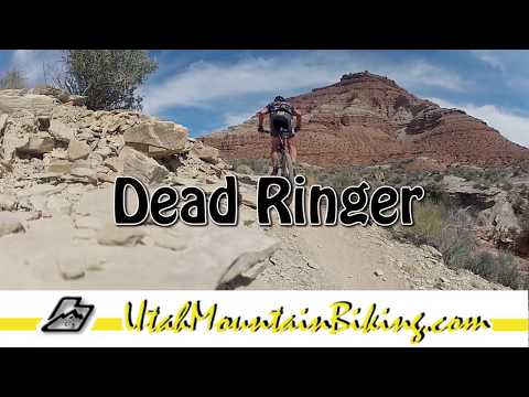

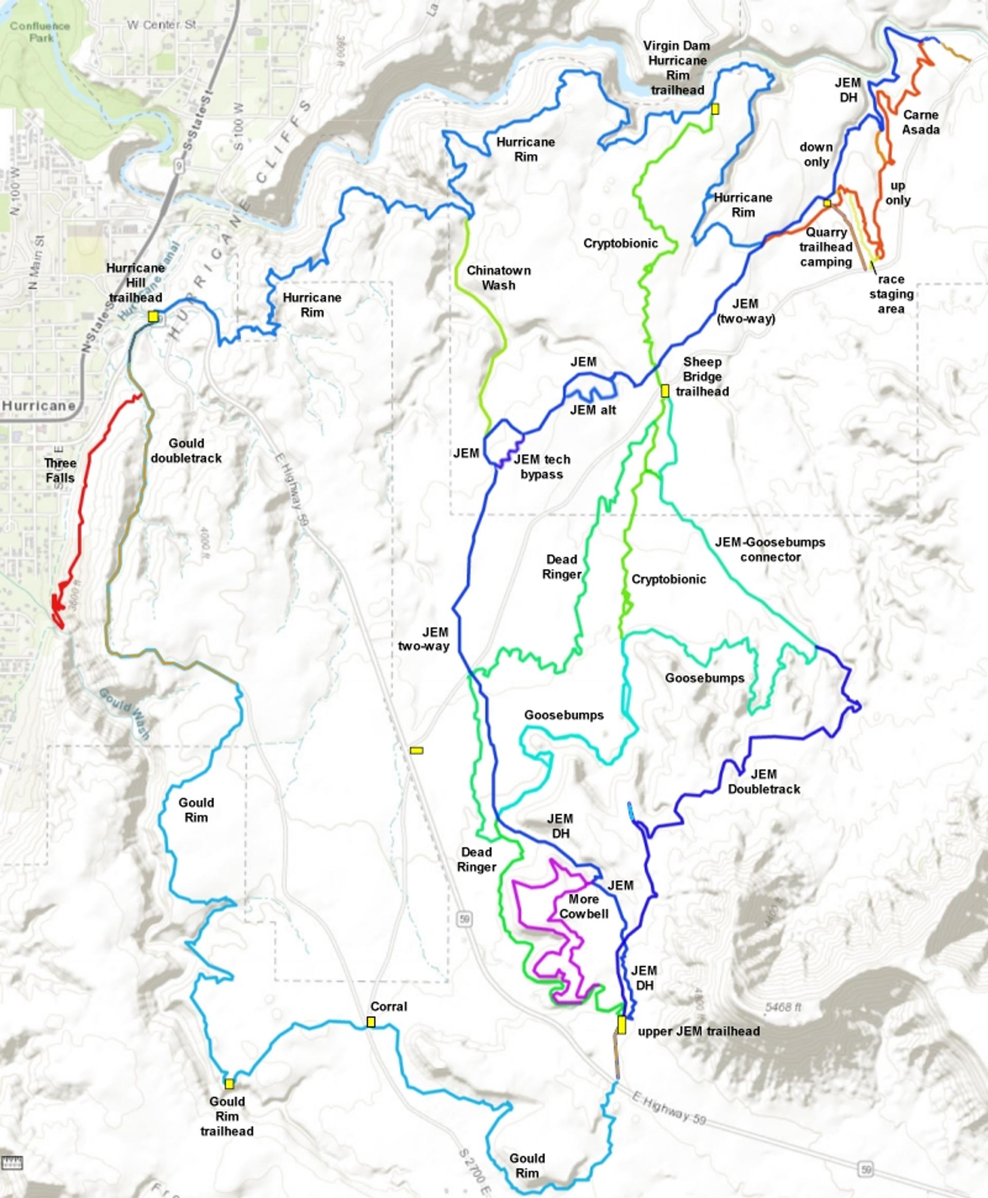
Dead Ringer is a fun singletrack in the JEM riding area. It extends from the upper (Highway 59) JEM trailhead downhill to end on Cryptobionic just north of Sheep Bridge Road. It was completed in early 2015, creating many new riding options in the JEM area. The trail was a joint project of the BLM and the Dixie Mountain Bike Trails Association (DMBTA).
Experienced beginners can ride this trail if they know how to get their butt off the saddle while the bike rocks. The western (downhill) end of the trail has a lot of quick up-and-down bumps, like the Goosebumps trail.


Between the Highway 59 trailhead and Cryptobionic, Dead Ringer connects to both ends of More Cowbell . Down the hill, a spur goes over to the Goosebumps intersection with JEM . Further on, the trail crosses JEM before meandering over to Cryptobionic. These connections divide the trail into thirds: 59 to Goosebumps, Goosebumps fork to JEM crossing, and JEM to Cryptobionic. Riders can combine any of these portions into a custom ride.


For beginners, a very nice ride (with nothing technical and minimal climbing) is to combine the upper 0.4 miles of Dead Ringer with More Cowbell , a side loop on the white limestone ledges near the top. This ride starts from the upper JEM (Highway 59) trailhead.

In Hurricane, turn south on US-59 (towards the Grand Canyon). Drive exactly 5 miles uphill. Turn left on cindered doubletrack right as you approach the base of Gooseberry Mesa. Drive another 0.3 miles to the parking area. Cross the cattle guard at the gate, then immediately turn LEFT on singletrack. Keep left at the next trail fork, then left at the "cowbell" at the top of the cliffs.

This trailhead with bathroom and bike stand is found
half-way along the gravel Sheep Bridge Road, which connects US-9 to US-59. Drive toward
the upper JEM trailhead on Highway 59 as above. But at mile 3.3 (while
still on the flat area), turn left on gravel Sheep Bridge road. Drive 2.9 miles on Sheep Bridge
road to a fenced parking area with a bathroom. Cryptobionic and
northern Dead Ringer can be found here.
Option, roadside
parking off US-59: If you turned onto Sheep Bridge Road from Highway
59, immediately park on the
right, just inside the fence. Pedal 0.4 miles northeast to where the JEM
singletrack crosses.

From Highway 9 in Virgin, turn south onto Sheep Bridge Road. Drive 1.7 miles. As the gravel road drops into a dip, there are two paths on your right. The ridgeline road is the race staging area. There's a connector to Carne Asada in about 100 feet on your right. The second dirt road, around 50 feet downhill, is the primitive camping and trailhead area. JEM crosses this road at the bottom of the camping zone, and Carne Asada is found to your right on JEM downhill from the road.

This trailhead serves the Hurricane
Rim and Gould's trails. Other trails in the system are reached via these
trails. In Hurricane, turn south on US-59 (towards the Grand Canyon).
Follow the road uphill 0.9 miles, then turn left into the trailhead
parking near the cell phone towers. The dirt road 0.2 miles back down U-59
is the trail's start.
Option, Gould's Wash corral: As you head uphill on Highway 59, pass
gravel Sheep Bridge road on your left (about half-way between Hurricane
Hill and the JEM trailhead). Now watch for a dirt road on your right. It
will take you to the corral. If you're heading for the rim, go directly
west from the corral for 1/2 mile.
, just 100 feet from the trailhead at the end of the doubletrack.")
In La Verkin, turn east onto Highway 9 toward Zion National Park. Drive 4 miles uphill. Just after you reach the first homes approaching Virgin, find the cindered Sheep Bridge Road on your right. Descend toward the bridge across the Virgin River and find a parking spot along the road. Start pedaling. Just past the bridge, but before the cattle guard, there's a dirt road to the right. This will take you to the bottom of JEM and Carne Asada. (The parking directly at the bottom of JEM is reserved for the nature conservancy.)


You can join Dead Ringer in the last two miles by climbing Cryptobionic to its end, then forking right on Goosebumps and climbing to the top. At the point where the Goosebumps hits JEM , go straight across and you're on Dead Ringer. It's 1.9 miles from the Goosebumps/JEM intersection to the upper Highway 59 JEM trailhead, with 300 vertical feet of climbing.
NOTE! If someone says "meet me at Sheep Bridge road," be sure you know if it's at Highway 59 (up the hill from Hurricane) or Highway 9 (just outside of Virgin on the way to Zion National Park). Sheep Bridge Road goes all the way from Highway 9 to Highway 59.


After taking Dead Ringer uphill, its top end connects directly to the upper end of the JEM singletrack near the trailhead.


1. Take the spur to Goosebumps for an eastbound ride. Do all of Goosebumps, or connect to Cryptobionic for a quick northbound trip to Hurricane Rim.
2. Transfer to JEM. Either at the Goosebumps spur or the JEM crossover, turn left on JEM for a fast descent.
3. Loop around. At the bottom end, turn right uphill on Cryoptobionic for a little loop ride.
Some riders are combining Dead Ringer with the lower half of Cryptobionic as a variation on the Hurricane Loop ride.


Now you'll encounter a few other forks. These are A-B lines. The "green" route is a ride-around for a stunt such as a rock rollover. The lines will rejoin in 50 feet of so.


0.0 DT, cross cattle extruder
N37 08.342 W113 14.524
L downhill on Dead Ringer
N37 08.361 W113 14.517
0.4 Fork L (R= More Cowbell)
N37 08.488 W113 14.640
0.5 Fork L (R = return More Cowbell)
N37 08.408 W113 14.734
1.8 Fork L (R = to JEM/Goosebumps)
N37 09.035 W113 15.092
2.7 Cross JEM N37 09.648 W113 15.230
5.0 R on Cryptobionic N37 10.590 W113 14.372
5.9 L for uphill (rejoins)
Loop around to keep mileage accurate!
6.6 L for uphill (again, loop around*)
8.0 R for uphill (loop around*)
8.7 Cross JEM to Dead Ringer
N37 09.111 W113 15.109
8.8 Keep straight
N37 09.035 W113 15.092
10.0 Straight (L = More Cowbell)
N37 08.408 W113 14.734
10.1 Straight (L = More Cowbell return)
N37 08.488 W113 14.640
10.5 DT, R to TH
If you don't do loops on 3 A/B lines*
above, your mileage will be 0.4 less

In Hurricane, turn south on US-59 (towards the Grand Canyon). Drive exactly 5 miles uphill. Turn left on cindered doubletrack right as you approach the base of Gooseberry Mesa. Drive another 0.3 miles to the parking area. N 37 08.329' W 113 14.527'. Pedal across the cattle extruder, then fork left downhill as you reach the Dead Ringer singletrack.
From the Highway 9 trailhead:
From I-15 north, take the La Verkin exit on UT-17. From the south, take the Hurricane exit on US-9 and go through Hurricane towards Zion National Park. At the junction of US-9 with UT-17, turn east towards Zion. 4.8 miles after the turnoff, turn right (south) on a gravel road signed "Sheep Bridge Rd." Descend toward the bridge across the Virgin River and find a parking spot along the road. Start pedaling. Just past the bridge, but before the cattle guard, there's a dirt road to the right. This will take you to the bottom of JEM and Carne Asada. (The parking near the bottom of JEM is reserved for the nature conservancy. There is no longer a "lower JEM trailhead.") Pedal Carne Asada uphill to JEM, then continue uphill and fork left when you reach Cryptobionic. Then fork right when you reach Dead Ringer.
NOTE: Do not damage these trails by riding when wet. For current conditions, contact Over the Edge Sports, 76 E. 100 S. in Hurricane, 435-635-5455.
Hurricane Hill trailhead: As above, turn south in Hurricane on US-59 Follow the road uphill 0.9 miles, then turn left into the trailhead parking near the cell phone towers. GPS N 37 10.740' W 113 16.601', Alt=3650'. The Hurricane Rim trail begins along the fence, heading northeast. To get to Gould's, roll down the highway (caution!) 0.1 miles then veer left to the steep doubletrack.
Riding resources for this trail:
One-page riding
guide, above lariat loop
GPS track files (right-click and "Save as..."):
Lariat Loop ride
as above
Dead
Ringer only
JEM area multi-track
file
Connecting trails:
Hurricane Cliffs Trail
Summary page
Gould's
Connector
JEM trail page
Goosebumps/Cryptobionic
trail page
JEM DT
Hurricane Rim page
Goulds Rim page
More Cowbell (White Ledges
beginner loop) page
Map for printing:
View
Lodging, camping, shops:
Links to St.
George area resources


