

Access DT, Lower Corner Canyon, Creekview, Rush Green
Draper's Corner Canyon offers a lot of riding. The trail system is close to civilization -- a bit famous -- This page describes only the lower trails between the Equestrian Center parking and the Corner Canyon Bonneville Shoreline Trail. See the Corner Canyon Overview Page for links to other trail pages for the Draper area.
We've been riding these trails for a long time! Latest page update by Bruce in June 2019.Some Corner Canyon trails are open year-round, regardless of weather, while others will be temporarily closed when muddy. For example, the main Access trail (a cindered doubletrack) in lower Corner Canyon is open year round. See the Corner Canyon trail closure page for the status of your intended trail. Riding in squishy conditions can still damage these trails, so use good judgment for the sake of your fellow riders!


The trails in lower Corner Canyon are beginner to early-intermediate in technical skill requirement. There are some rollers on the Rush (Green) beginner downhill, but nothing tricky.
The climb to the Bonneville Shoreline (BST) trail from the parking lot is 300 vertical feet over one mile, making the pitch tolerable even for beginners.


First, get to the junction of the Lower Corner Canyon trail and the Access trail. If you're at the main parking lot, find the paved path on the west end of the parking lot. Descend away from the road until you see singletrack heading the other way. Now make a hard left turn toward the underpass and go under the street.
As you exit the underpass, decide which trail you want to take uphill. The broad path straight ahead is the Access trail. If you make a left turn, you'll climb up to a singletrack running near the sidewalk, which is the Lower Corner Canyon trail..


300 ft on your R: Do not enter. Exit from one-way Rush Green.
0.2 mi on your L: Do not enter. Exit from from Old Creekview down.
0.2 mi on your R, before bridge: Entry to 2nd half of Rush Green one-way.
0.2 mi on your R after bridge: Do not enter. Exit from one-way Rush.
0.3 mi, hard R: Entry to Rush Green one-way downhill.
0.35 on your R: Do not enter. Creekview foot path.
0.35 on your L: Connector to Old Creekview down and to midpoint of Lower Corner Canyon uphill trail.
0.4 on your L: Do not enter. Short downhill meander off main trail.
0.45 on your L: Do not enter. Downhill from Lower CC ST
0.6 DT joins on L: L takes you to downhill trail near end of Lower CC ST.
(continued below)


0.8 on your R: Connector to Rush Limelight downhill trail
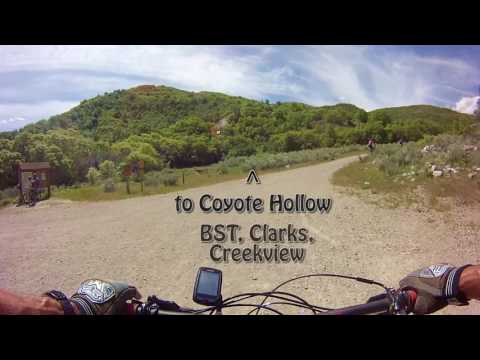
0.95 BST, 4 options!
L = eastbound BST to Gasline, Rattler, etc
straight on DT = to Canyon Hollow connector, Gasline, Ghost Falls
NOTE! Creekview is now one-way. You can't enter it on the BST end.
straight to ST = Do not enter (exit from upper Rush)
R on DT = BST to Clark's, Canyon Hollow, Potato Hill
Hard R to ST = Rush Limelight downhill

The trail will hug the hillside just below the homes for a bit. At mile 0.3, there's a connector to neighborhood streets on your left.
The right fork is the Old Creekview downhill trail, and will take you down to the Access trail near the entry to the bottom half of Rush Green.


In a few feet, a downhill trail forks away on the right, and in 100 yards, the doubletrack joins the main Access trail heading uphill. You can go either uphill or downhill on the Access trail.
At the top of the doubletrack, to your left is the eastbound Bonneville Shoreline Trail , which can take you up to Rattler . (These are also all-weather trails.) Straight ahead is doubletrack that can take you uphill to connect to Canyon Hollow or Ghost Falls . To the right is the westbound BST, which can take you to Clark's or the Coyote Hollow trailhead.
For those who don't live in the nearby neighborhood, the only remaining function for Creekview is as a "bailout" from Rush Limelight to go back uphill toward Coyote Hollow.


The Rush trail is covered in detail on another trail page. The entry to lower Rush (called Rush Limelight) is on the Bonneville Shoreline Trail just west of the 4-way intersection with the doubletrack Access trail. When climbing the Access DT, pass the connector to Rush at mile 0.9, and keep right as you approach the 4-way. At the 4-way, curve right to make a 180 degree change of direction into the singletrack.


Older video climbing Lower Corner Canyon and descending Creekview (now you must use Rush)...
Good ride for beginning bikers who are improving their skills but won't last through a long uphill grind. Great for a quick after-work outing.


Take the Bluffdale exit from I-15 and turn east towards the mountains on Highland Drive. Go straight past the railroad underpass. Stay on Highland until you reach the parking area for the Lynn Ballard park on your left. To reach the trailhead from the north (Sandy area), take 13th East southward until it ends at the stop sign just past the underpass. Turn left and drive 1/4 mile to the main parking.
To find the trail, go to the west end of the parking area near the trail kiosk. Drop down the hill on the paved route, then make a hard left on a broad southbound trail. Go into the tunnel under the road to ride climb either the Access DT or the Lower Corner Canyon singletrack.
Facilities: Water and flush toilets at the Equestrian Center.
Corner Canyon area trail overview page
GPS track files (right-click and "Save as..."):
Master File of Draper Area GPX tracks
Maps for viewing or printing:
View 2019 topo map
Lower Corner Canyon aerial closeup as above
Lodging, camping, shops: Links to southern SLC resources


