
Cranking uphill to the Broken Mesa Rim. Original photos and review in June 2002 by Bruce. New photos and information update May 11, 2017.
Broken Mesa Rim Trail
When the guys at the local bike shop say "This is the most fun trail I've ever ridden!" you have to pay attention. Of course, their definition of "fun" includes a tough initial climb, tricky spots involving rough bone-jarring lava boulders, and a half-mile plunge that's truly steep and dangerous.
When the guys at the local bike shop say "This is the most fun trail I've ever ridden!" you have to pay attention. Of course, their definition of "fun" includes a tough initial climb, tricky spots involving rough bone-jarring lava boulders, and a half-mile plunge that's truly steep and dangerous.
Located 5 miles north of St. George, the Broken Mesa Rim trail should be reserved for strong
and adventurous riders. The trail can be ridden year-round. The downhill
singletrack is 7 miles,
with an initial uphill mile that climbs 600 vertical feet. It can be done
as an 8-mile point-to-point
with shuttle, or as a 14.5-mile loop. If you do the loop option, you'll
climb a total of over
2000 vertical feet.

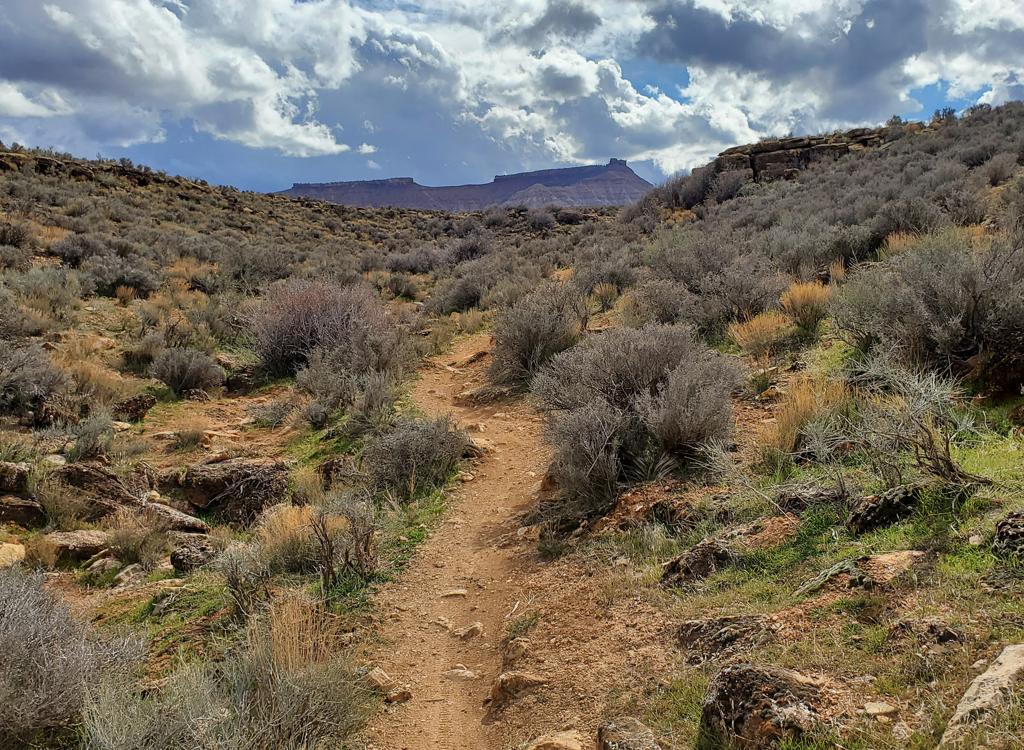
There are frequent switchbacks during the initial climb.

We're up in the fire-scar area, ready to rock some boulders. Behind me is the "ramp" down toward Washington where we'll soon be bombing downhill.
There are a lot of small ledges and thread-the-needle passages through volcanic rock. The trail
is best done with a plush full-suspension bike, but a skilled rider on
a hardtail can still
have fun. The lava boulders create a different type of "technical" than
you're used to, so
-- forewarned -- many riders don't like this trail. The lava is also very
good at flatting
your tires, so come prepared.
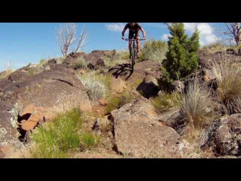
To say this trail is "rocky" is like saying water is wet. There are loose chunks in the trail's
riding line, big and small. There are inconveniently-placed embedded boulders.
You will bang
your pedals.

Even though the trail is rough, you'll want to lock your rear shock for the climbing. Eliminating pedal-bob makes you much less likely to strike a pedal as you climb through the rough stuff.

Heading toward the top, with the Pine Valley Mountains behind me. Drone shot.
There are great views from this trail. To the north are the Pine Valley Mountains. On the east
are the mesas near Hurricane.
Although the Broken Mesa Rim is a few degrees cooler than St. George, it gets plenty hot here
in the summer. I'd suggest you make the initial uphill climb in the morning,
perhaps starting
at the water tank if you're doing the loop.

This is trail? It's my job to show you exactly why many riders won't do Broken Mesa!

And we're cruising! Eastbound.
The trail starts at the northern end of the Red Cliffs Desert Reserve. The first part of the
singletrack climb is fairly smooth, then it gets steeper and rougher.
At 0.5 mile, the trail
reaches a doubletrack with a pipeline on the far side. Find the continuing
singletrack trail
on your right, just across the pipeline.
Here you'll encounter dead trees from the fire in 2006. The shrub vegetation has recovered
well, and is now beginning to encroach on the trail's riding line. Here
also the climb gets
a bit more technical, with frequent basalt rocks to negotiate.

From time to time, you'll be back in the basalt.

Joining the Icehouse Trail.
Depending on recent weather and trail maintenance, parts of the trail will be quite rough with
large loose rocks. If bike control through loose cobble isn't your thing,
reconsider whether
you want to try this trail. Check with a local bike shop for current trail
conditions.
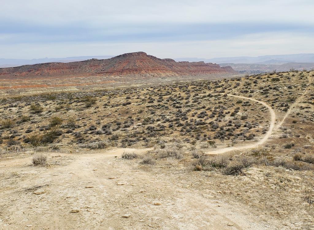
At mile 1, the trail reaches the Broken Mesa Rim. It twists through juniper and brush, with
more basalt boulders to keep things interesting. At mile 1.6, the downhill
begins. You'll drop
onto a broad treeless mesa as the trail twists towards the edge of the
cliffs at Washington.

Icehouse is much smoother and straighter. The next two miles of the ride will only take a few minutes.

No stopping now! My Rocky Mountain steps down the stairs at the top of the mesa.
Broken Mesa joins the Icehouse Trail at mile 4.3. From here, it's a straight shot toward the cliffs west of Washington. This part of the ride is a cruise.
At mile 6.2 you'll reach the edge of the bluff. Here you'll drop at a 20% grade through the
broken lava. Just hang your butt way back and aim the front tire straight
down the trail. Keep
the bike moving. If the bike hangs on a boulder, bail off the back end.

Did I mention that this part is very rough and very steep?

Off the mesa. Now we just have to get back to the car.
Reaching doubletrack at the bottom of the hill, you can turn right to complete the loop. 2.4
miles takes you back to the water tank, where you turn right uphill to
follow the road back
to the trailhead.
Alternatively, you can go straight across the powerline doubletrack and follow the faint singletrack down to Washington and hit the city streets.
Alternatively, you can go straight across the powerline doubletrack and follow the faint singletrack down to Washington and hit the city streets.

Wilderness border on Icehouse, with a stepover for bikes.
Icehouse Trail Option...
The Icehouse Trail joins Broken Mesa near the end of the ride. You can ride up-and-back from the junction. Or, now hear me out, you can skip Broken Mesa and instead simply ride Icehouse from the top. Local riders think the Fun-to-Work ratio is much higher on Icehouse than Broken Mesa.
To get to the top of Icehouse, go northeast from the Broken
Mesa trailhead turnoff. Drive 2.2 miles, keeping right at the road fork.
Then fork southeast on FR 092 for 1.1 miles on primitive dirt road. The trail starts at the gate, about N37 13.71 W113 32.11.
See the Icehouse Trail page.
Icehouse has 3.5 miles of downhill before it hits Broken Mesa. If you continue all the way to Washington (see the GPS track file), that's 6.8 miles of downhill cruising.

Looking downhill as the Icehouse trail winds toward Washington.

Quickie map of the Broken Mesa ride.
Getting there: From the St. George Blvd exit of I-15, turn
towards the city (west), then immediately turn right on 10th East. Zero
your odometer here. Take the next right on Highland, then next left onto Industrial Road. Turn left
at 0.7 on Red Rock Road. Keep left at the next
fork, continuing north uphill on Cottonwood Road. (At 3.3 miles, you'll pass a water tank on your right. The return trail for the
loop option comes back here. You can park here and bike up the road if you
want to.) Pavement ends at 3.7. Keep left at the next fork at 5.4. Watch for a sign "Red Cliffs
Mesa Rim Trail" at mile 8.8 and turn towards a fenced parking area
at a stock watering trough at mile 9.0. GPS N 37° 13.451' W 113° 34.197'
Southbound (Washington): Southbound on I-15, exit in Washington at Exit 10 (Green Springs Drive). Turn right as you exit, then immediately turn left on Red Hills Parkway. Drive 1.5 miles, then turn right on Cottonwood Road.
Southbound (Washington): Southbound on I-15, exit in Washington at Exit 10 (Green Springs Drive). Turn right as you exit, then immediately turn left on Red Hills Parkway. Drive 1.5 miles, then turn right on Cottonwood Road.
Shuttle option: Leave a car on Buena Vista Blvd, just off I-15's Exit 10 in Washington. As
you finish the steep downhill, find ST across the doubletrack (alternate:
turn left on powerline
doubletrack, right on ST at second pole), then work your way downhill
through the golf course
and into town.
Riding resources for this trail:
Single-page riding guide
GPS track files (right-click and "Save as..."):
GPX
High-res topo (800 KB): View
Lodging, camping, shops: Links to St. George area resources
Single-page riding guide
GPS track files (right-click and "Save as..."):
GPX
High-res topo (800 KB): View
Lodging, camping, shops: Links to St. George area resources
Original review 2002, updated 2008 and 2017.