

View in the narrows of Black Dragon Wash, looking east downhill. The cliffs are Navajo sandstone. Original photos November 4, 2002 by Bruce, with update in 2017
Black Dragon Wash
Black Dragon Wash is located on the eastern cusp of the San Rafael Swell. This ride has two highlights: a doubletrack ride through the narrows, and a broad slickrock ramp that climbs to a view into the narrows, from 800 feet above the wash. The area sees only occasional riders, as it's remote -- and Moab draws away riders because it's not far from here.
Black Dragon Wash is located on the eastern cusp of the San Rafael Swell. This ride has two highlights: a doubletrack ride through the narrows, and a broad slickrock ramp that climbs to a view into the narrows, from 800 feet above the wash. The area sees only occasional riders, as it's remote -- and Moab draws away riders because it's not far from here.
The narrows can be done as an out-and-back from the bottom (10 to 28 miles depending on the
turnaround spot), or as a shuttle ride of 14.7 all-downhill miles. Because
of loose rock and
some tricky wash-crossings, the ride would be intermediate technical overall.

Bruce cruises under domes of Navajo sandstone in November 2017.

The upper 2/3 of this ride features bluffs and mesas of orange and yellow, with doubletrack rolling down towards Black Dragon.
The one-way ride starts high in the mesa area of the San Rafael Swell. After a couple of flat
miles, it descends another 12 miles. The last 3 miles are in the depths
of Black Dragon Wash,
where sandstone cliffs tower 800 feet high over the 30-50 foot wide canyon.
Riding surface
is doubletrack, with occasional ledges, rocky areas, and tricky spots.
The ride's highlight is Black Dragon Wash. The rock layers here on the eastern side of the
San Rafael Swell are tilted upward towards the west. As you ride down
Black Dragon, you're
going UP in geographic layers (and closer to the present in time), even
though you're riding
downhill.

Approaching Black Dragon from the west. Navajo sandstone is seen as white rock in the canyon, near the horizon. Capping the vertical Wingate cliffs is Kayenta. The first "skirt" layer is Chinle, then the fluted brown and yellow Moenkopi. These strata are from the Triassic Period.

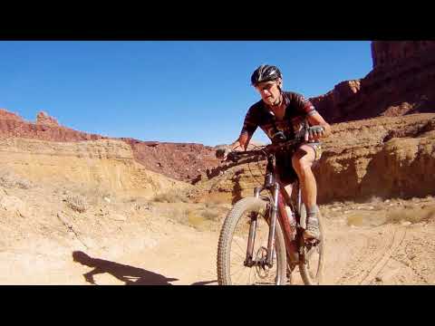
Here in Wingate and Kayenta sandstone, the tiny speck in the lower middle is me, riding my Rocky Mountain Element in 2017.
Before entering the wash from above, you're riding on limestone and shale from the Permian
Period. The skirts of the cliffs, and some of the shale and mudstone cliffs,
are layers of
the Moenkopi Formation, from the early Triassic Period. The Chinle Formation
here is a bit
different than near Moab. It consists of two layers of dense sandstone,
rather than just loose
clay. The first set of sheer skyline cliffs you encounter going downhill
are Wingate sandstone,
capped by the layered Kayenta sandstone.
 | Rock paintings are seen on the canyon walls about 0.6 miles from the lower trailhead. A log fence marks the spot. |
|


Bruce rolls down the last section of the narrows, in a narrow passage through the Navajo sandstone.
The Navajo sandstone forms the last set of cliffs within the narrows, and the sharktooth eastern
ridge of the Swell. Towards the end of the narrows, the canyon is only
about 20 feet in width,
with cliffs towering hundreds of feet above the trail.
Slickrock above Black Dragon:
At the lower trailhead, a fairly smooth ramp of Navajo sandstone climbs up the eastern sharktooth edge of the Swell. The slope is a fairly stiff 20%, but the rock is broad and smooth enough that you can ride it easily by zigzagging up. The rideable area is almost a square mile overall. This side trip up the slickrock is NOT to be missed!
At the lower trailhead, a fairly smooth ramp of Navajo sandstone climbs up the eastern sharktooth edge of the Swell. The slope is a fairly stiff 20%, but the rock is broad and smooth enough that you can ride it easily by zigzagging up. The rideable area is almost a square mile overall. This side trip up the slickrock is NOT to be missed!

View upward, about 1/2 mile up the slickrock area. Lots of rock to explore.

View from a perch on Navajo sandstone high over the the narrows of Black Dragon Wash. The late afternoon sun is yielding to a crisp November chill.
About 3/4 of a mile up the slickrock ramp, head to the left side for a jaw-dropping view down
into the narrows. You're 800 feet above the bottom of the wash. Pick your
way higher up for
additional viewpoints into the canyon.
There's about a square mile of open rock here, bounded on the north by cliffs above the San Rafael River, on the south by Black Dragon Wash, and on the west by breaking edges of Wingate sandstone cliffs.
There's about a square mile of open rock here, bounded on the north by cliffs above the San Rafael River, on the south by Black Dragon Wash, and on the west by breaking edges of Wingate sandstone cliffs.
One-way from Upper Trailhead:
1.8 Fork L, N 38° 54.991' W 110° 34.455'
2.7 Straight (L), N 38° 55.425' W 110° 33.708'
4.5 Straight (R), N 38° 56.479' W 110° 32.921'
6.2 Fork L (north), N 38° 56.468' W 110° 31.288'
6.7 Fork R (east), approx N 38° 56.8' W 110° 31.1'
11 Entering canyon
14.7 At lower trailhead
1.8 Fork L, N 38° 54.991' W 110° 34.455'
2.7 Straight (L), N 38° 55.425' W 110° 33.708'
4.5 Straight (R), N 38° 56.479' W 110° 32.921'
6.2 Fork L (north), N 38° 56.468' W 110° 31.288'
6.7 Fork R (east), approx N 38° 56.8' W 110° 31.1'
11 Entering canyon
14.7 At lower trailhead
Riding notes, Out-and-back:
Just head up the canyon narrows. Steepest section is between mile 3 and 4, after the canyon opens up. Keep on main trail (R) at fork around mile 2.7. Good turnarounds are mile 5 (across from freeway view area), mile 10 (Jackass Benches road), or mile 12 (gate where the climbing stops).
Slickrock ramp: At the lower trailhead, drop off the road into the wash. Go west 100 yards, then fork R. Aim for right edge of slickrock to get on ramp, then keep generally L to viewpoint 0.7 miles up. Climb further, or stay and play.
Getting there:
Eastbound on US-191, turn west (right) onto I-70. Nine miles later, cross the San Rafael River. Slow down and get ready! 0.3 miles later, watch carefully for a gravel turnaround between freeway lanes, with a dirt road leaving the freeway on the right. (The dirt road is hard to see until you're passing it. N 38° 55.531' W 110° 25.023') Go through the gate, turn L through the wash. At 0.6, keep straight (R). At 0.9, turn left and park 100 feet later. N 38° 56.239' W 110° 25.135'.
Start the ride here for out-and-back, or go back to the freeway for a shuttle ride. Back at the freeway, turn right (west) and drive uphill 15 miles. Get off at Ranch Exit 131 (also listed as Exit 129 -- the I-70 exits have been renumbered in recent years), and turn right driving back east parallel to the freeway on the road to the San Rafael River Bridge. At mile 2.6, keep straight (left). After passing The Sinkhole, turn right at the next fork and park to begin the ride (N 38° 55.742' W 110° 36.027').

View down the slickrock area, looking east. The snow-capped La Sal Mountains can barely be made out in the distance.

If you need more miles, the
Three
Fingers Canyon ride
is just across the freeway (through the wash under
I-70), and can give you 16.6 easy miles and a chance to see a different
type of rock art.
Printable
one-page
riding guide
GPS track files (right-click and "Save as..."):
GPX
Topo map for printing (Canyon):
View
Lodging, camping, shops:
Links to Price and San Rafael area resources
Links to Moab area
resources
Updated 2017


