Bruce hits an alternate line towards Bloomington. Original review by Bruce August 1, 1998. Trail page last updated November 2019.
Bearclaw Poppy TrailThe Bearclaw Poppy Trail lies southwest of St. George. It
joins Green Valley to the west side of Bloomington, curving scenically
around Bloomington Hill. There are trailheads at Green Valley and
Bloomington, 4.1 miles apart. The contour is downhill as you head from
the
escarpment above Green Valley towards the Bloomington end. The trail is
a
nice stand-alone ride, but you can also use this mountain bike trail as
a piece of a much larger
ride including
Stucki Springs
.
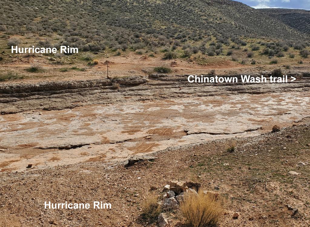
The southern half of the trail (from the Stucki Springs trail fork to Bloomington) is now one-way -- southeast downhill towards Bloomington. To ride south-to-north, you'll need to use the northern half of the
Bloomington
Microloop
, which has now been renamed as the "Bearclaw Up" trail. Bearclaw Up takes you to a 4-way, where a right turn connects to Bearclaw Down just below Clavicle Hill. See the map link below for a printable
area topo.
 is now one-way -- southeast downhill towards Bloomington.")
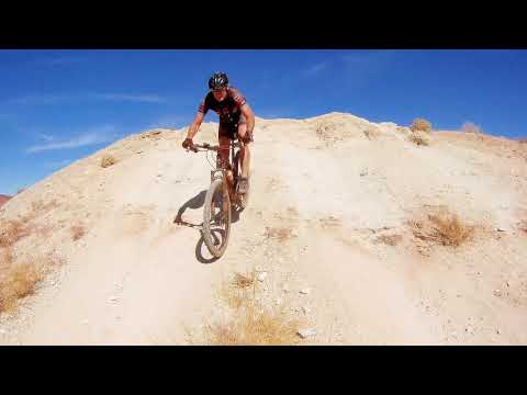
There's easy stuff and there's hard stuff. Here Bruce hits the notorious Clavicle Hill. (There are ride-arounds for the trickier stunts.)

Cruising southbound between The Wash and the Acid Drops.
This trail is a blast to ride. You'll soon see why it's the most popular trail in St. George.
Highlights include a not-too-tough one-mile hill climb, a run down a desert
wash, a series
of short "scary but not too hairy" drop-offs, and a roller coaster hard-pack.
The ride is so
classic that the trail sections have special names.
Most riders do Bearclaw as an out-and-back, but using the
Bloomington Trail
westbound from the Bloomington end. The northern side of the Bloomington
loop runs westbound parallel to the section of Bearclaw that's eastbound
one-way.

View from the hill after you come up past the Green Valley Spa. Follow the dirt road down, to the left, then uphill to reach the parking for Bearclaw Poppy. Many bikers park right here to begin their ride. See the Zen and Racetrack pages. Photo December 2011. The bottom of the valley area will be seeing subdivision construction some time in the future.

The Green Valley trailhead is across a small valley from the homes on the Green Valley bluff. There's a repair stand, but no other services at this trailhead. (We're looking back toward Green Valley as the trail starts with a bit of gravel road.)
You can ride this trail year-round. At an elevation of 2700 feet near the Arizona border, this
trail never sees snow. However, during wet weather the clay can become
saturated.You'll damage the trail. And during the winter months, check with a local shop for current
conditions.
The Bearclaw Poppy lies in a special preserve area. The preserve protects the endangered Bearclaw
Poppy. Absolutely DO NOT EVER ride off-trail. And don't follow other riders'
illegal "alternate
lines" -- stay on the main path. If cyclists don't respect the preserve,
we may find ourselves
locked out. Really.

Bearclaw Poppy. Seriously, don't be a jerk. Stay on the trail, and don't ride when the ground is wet.

Dominic Bria, one of the original founders of UtahMountainBiking, rides the doubletrack between the Green Valley trailhead and the preserve entry gate in 2000.
I'd rate the trail moderate aerobic and intermediate technical overall. If you don't stop to
play, it's very quick ride -- one you can easily hammer in the morning
before work or golf.
If you start from the Bloomington end and turn around at Clavicle Hill
-- which is my recommendation
for kids -- it's easy aerobic and easy-beginner technical.
From the Green Valley end, the trail starts with a modest one-mile warm-up climb along the
side of a sandstone canyon. (That's if you ride to the trail from town.
If you drive to the
new parking area, you'll have only a short jaunt uphill. The step-over
gate marks the border
of the preserve, and the start of the singletrack.) Hilltop GPS N 37°
05.162' W 113° 38.831'.

Bruce's Superfly 100 leans against the border of the preserve in December 2011 photo. Just downhill are the Three Fingers of Death! Let the fun begin.

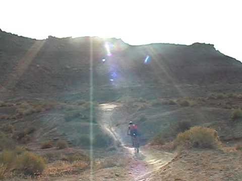
Plan your route. There's an easy way around the "Three Fingers of Death" called "Flatline." After the Three Fingers of Death, the trail winds along the a wash (the dark streak at center right). Picture August 1, 1998
The trail descends into a roller-coaster BMX course in red, white, and orange desert dirt.
Right away, the singletrack drops downhill over a couple of little ledges.
Beginners, remember
to let the bike roll as you hit the scary stuff, then carefully brake
after you're back on
smooth trail.
First the red stuff: the "Three Fingers of Death." Plunge down to the valley floor. Of the
options here, the left "finger" is easier. To the right, the options get
more scary. People
get hurt here, so chose wisely based on your ability.
Or, hold to the right after the initial descent and find the singletrack "Flatline Trail" that
winds around at a more leisurely pace. It will be on your right just before
you reach the Three
Fingers, and crosses the path down the Fingers. (This singletrack will
be your uphill route
if you're doing the ride as an out-and-back.)

The Three Fingers of Death will vary based on yearly erosion. Here Bruce hits a vertical drop in November 2019.

Winter's view in the Wash, heading southbound.
Next comes orange dirt: "the wash." Rock and roll across the desert on the firm wash bottom.
Hit the sidewalls to add to the tech factor.
If you find wet dirt while in the wash, GO BACK. The clay that lies ahead will not heal if
you damage it by riding while it's wet.
From the wash, the trail rolls over some more orange dirt before reaching the white clay of
the "Acid Drops." You'll notice a couple of side routes. Stay on the main
trail. Keep heading
straight south-southwest. The first one on the left rejoins at the Acid
Drops. The three routes
heading right (north) join to form the Stucki Springs cutoff route. A
side route on the right
with multiple interconnectors and drops into a wash that parallels the
Acid Drops.

Rolling over the top of an Acid Drop, you have to be prepared to let the bike fall. If you hit the brakes, you crash.

Throw the bike forward as you roll over the edge. If you let the nose fall, you'll endo. (To the right in this photo is a climbing route or an easier descending path.)
The Acid Drops challenge many intermediate riders. If you're a beginner, well, here's the secret.
Get off the bike seat. Put all your weight on the pedals so your butt
comes away from the seat.
Let the bike tip down, while your trunk stays balanced upright. If you
MUST brake, use only
a tiny bit of rear brake. Ideally, just let the bike roll. After you absorb
the "wump" at the
bottom with your flexed legs, sit down and begin applying the brakes.
The last of the Acid Drops is the dreaded Clavicle Hill! Yes, it's named after the body part
that it breaks. (GPS N 37° 04.209' W 113° 39.299')
Experts, go ahead and take some air off
the rock ledge at the top. Intermediates, pick the rock-free line and
let it roll. Don't over-brake, or you'll pitch over
the handlebars.

Dominic rolls Clavicle Hill in 2000.

Darren Harris heads up Clavicle Hill in this January 2010 photo. The Acid Drop section offers some challenges when ridden south-to-north.
Beginners can descend the "climber" route around the hill. As you approached Clavicle Hill,
there was a trail on your left about 150 feet back from the edge. (This
is the path that most
riders will take when riding from the Bloomington end or when returning
on an out-and-back.
It IS possible to ride straight up Clavicle Hill. But I've never succeeded
at it.)
As you come to the bottom of Clavicle Hill, turn left toward the mountain and pick up the continuing
Bearclaw Poppy Trail. (There's another drop just below Clavicle Hill,
also with a trail turning
left to Bearclaw at the bottom.) Straight ahead would take you to the
Stucki
Springs
trail and the
Bloomington Microloop
.

Authorized alternate routes are designated with carsonite markers.

Authorized alternate routes are designated with carsonite markers. Please do NOT follow cheater routes!
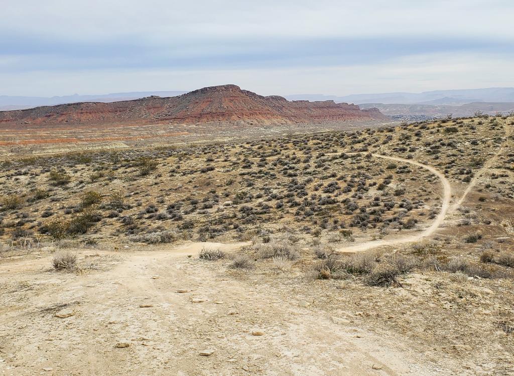
The trail will curve closely around the Moenkopi skirts of the mesa, Bloomington Hill. If you
find yourself away from the mesa in rolling desert at this point, you
probably missed your
turn. (Note: some riders become confused by the carsonite trail markers,
which say "Bearclaw
Poppy" on the top, even if those markers are located on the Stucki Springs
or Bloomington Microloop
trails. The whole area is the Bearclaw Poppy preserve.)
Now it's on to the rolling white clay south of Bloomington Hill -- known as the "Roller Coaster"
or "BMX Course." From here, the trail is one-way eastbound, slightly downhill
as it heads toward
Bloomington. The trail rock 'n rolls through hard-packed desert dirt.
Awesome! Keep on the
main trail at all times. Resist the temptation to "explore" -- whether
on foot or bike -- because
you're in the desert preserve. Go only on MARKED alternates.

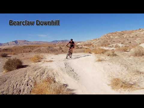
Drone shot as Bruce rockets eastbound on the Roller Coaster.
Rejoining the main trail from an authorized set of alternate lines.
In the winter, the temperature is usually nice for a couple of hours in the afternoon. I ride
this trail in shirt-sleeves in January. During the summer, it's best to
go early in the morning.
If you start your ride by 7 a.m., you'll enjoy pleasant temperatures.
If you're riding with children, I suggest you take them to the Bloomington trailhead. The combination
of Bloomington and the BMX section of Bearclaw is around 4 miles. They'll
enjoy the tamer stretches
of white clay trail on the Bloomington end.
 and Kristen (right, Bruces daughter) ...")
Savannah (white helmet, Dominic 's daughter) and Kristen (right, Bruce 's daughter) enjoy the rolling clay trail on a warm late-winter's day. March 5, 1999.

Above Bruce is the cap-rock forming the top of the Chinle formation. The trail runs on white clay.
The valley floor is shale of the Chinle formation of the late Triassic. During that time (about
220 million years ago), this corner of Utah was covered by shallow sea.
The sea gave way to
red mud-flat and flood deposits of the Moenave. The bluffs are capped
with lava flowing from
volcanoes of the late Cenozoic. The volcanoes in this area are an extension
of the northern
Arizona volcanic field, and were very active around 8 million years ago.
As the trail
reaches Bloomington, you can turn around for the out-and-back ride. Because
the eastern end of Bearclaw is one-way, your westbound trip will be on
the
Bloomington Trail
. This trail will deliver
you to a 4-way where you can turn north to Bearclaw.
There's a big double-trailhead with a bathroom at Bloomington.

Rolling into the parking area after a nice ride.
Riding notes, from Green Valley:
From end of pavement N37 05.516 W113 37.673
0.0 Go R 100 yards, turn L downhill
N37 05.568 W113 37.709
0.1 At bottom, veer L 100 yards,
then R to cross valley
0.3 Pass Zen trailhead, keep straight and climb
N37 05.433 W113 37.893
0.5 Parking
From parking lot on hill:
0.0 Around gate, uphill on DT
N37 05.338 W113 38.432
0.4 Pass Barrell ST on L, veer R
Step over gate to Bearclaw ST
N37 05.173 W113 38.826
0.5 Flat area, descend Three Fingers of Death
N37 05.119 W113 38.856
0.6 Straight and drop into Wash
N37 05.051 W113 38.781
1.1 Keep straight (R = to Stucki cutoff)
N37 04.790 W113 39.054
1.3 Keep R (L = alternate, rejoins)
N37 04.598 W113 39.130
1.4 Keep straight (full R = to Stucki
cutoff)
N37 04.543 W113 39.175
(soft R = alternate line, rejoins
vs
down wash)
1.5-1.6 Various alternate lines, keep straight
(to Stucki cutoff at N37 04.369 W113
39.238)
1.7 Straight (R = to Stucki cutoff)
N37 04.290 W113 39.273
1.8 Clavicle Hill, straight off
N37 04.220 W113 39.297
1.8 Left at bottom, head southwest
N37 04.214 W113 39.291
Straight = to Stucki Springs or
B.Microloop
R = to Snakepit Rim vs Stucki cutoff
1.85 Keep straight N37 04.208 W113 39.258
(L = back to top)
2.9 Alternate lines, select (R = easier)
N37 03.648 W113 38.392
3.3 Alternate lines N37 03.463 W113 38.058
3.5 Alternate lines N37 03.403 W113 37.898
3.9 Straight (B.Microloop joins on R)
N37 03.224 W113 37.507
4.0 Veer R to parking N37 03.204 W113 37.373
4.1 Stepover gate for Bloomington parking
N37 03.130 W113 37.355

Older map showing the pavement loop of historic Green Valley.
Getting there, Green Valley (Bearclaw) trailhead:
Take the Bluff Street I-15 exit in St. George and turn west. Immediately turn south (left)
at the first light. Go over the hill and at the T intersection at the
bottom of the hill turn
right. Head northwest about two miles on Dixie Drive. Turn left at Canyon
View Road, heading
uphill toward the Green Valley Spa. (If you reach a "Green Valley Market"
with gas pumps, you
just passed it. Turn around and backtrack to the second road on your right.)
Drive past the
spa onto dirt at the end of the road. Turn right at the top of the mesa,
then immediately left
to drive down into the deep valley. You can park here and ride to the
road that climbs the
RIGHT side of the little sandstone canyon. Or, you can stay in your car
and turn right on dirt,
then drop left down into the valley 100 yards later. Follow the improved
gravel road up to
the parking area about 3/4 mile later. Trailhead N 37° 05.509' W 113°
37.689'
Bloomington trailhead:
The Bloomington trailhead has become heavily used. It has plenty of parking
and a toilet. Go to the west end of Navajo Drive in
Bloomington. Go across the cattle guard and keep straight on the gravel
road.
Drive 100 yards past the flood-control structure, then keep right to
descend into the parking area. The upper parking has a bathroom and bike
repair stand. To reach the lower parking, drive to the end of the upper
parking lot and do a 180.
Riding resources for this trailPrintable, one-page riding guideLarger detail maps for printing:
Bearclaw
Plus Stucki Springs
Area
map, including connections to Barrel Roll areaTrack files (to download, right-click and select "Save target as..."):
Area GPX tracks (includes
side routes)
Major
trails (Bearclaw, Stucki, B.Micro, SnakePit)Specific rides, course file:
Bearclaw track
only
Bearclaw-Stucki
Loop from Green Valley
Bearclaw-Stucki-Snakepit
Loop from GV
CoveWash-Stucki-Bearclaw
big loop ride from Canyon View Drive
Bloomington-Snakepit-SouthStucki-Bearclaw
figure 8 from Bloomington
Bloomington-Bearclaw
little loop from BloomingtonOther tracks:
Bloomington
Microloop only
Stucki only,
from BearclawLodging, camping, shops:
Links to St.
George area resources 

 is now one-way -- southeast downhill towards Bloomington.")


 and Kristen (right, Bruces daughter) ...")