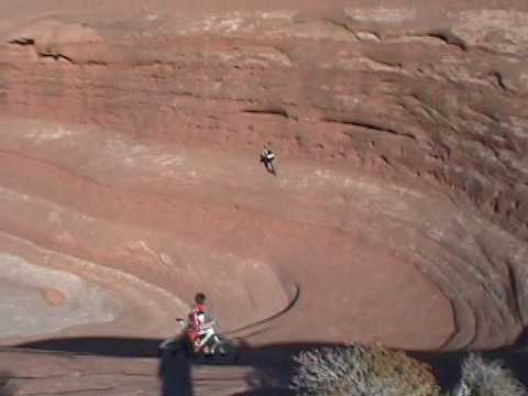

Matt rolls over the sandstone near the west end of the mesa at the top of Bartlett Wash. February 26, 2000. Photo by Bruce.
Bartlett Wash
Bartlett Wash is an Entrada sandstone slickrock ride featuring incredible views and fun undulating waves of great rock. This intermediate-difficulty ride is located 18 miles north of Moab. The "official" ride is 4 miles, but you can spend all day goofing off on large playgrounds of slickrock, as this mesa is an "open-riding" area where you can go anywhere you want.
Bartlett Wash is an Entrada sandstone slickrock ride featuring incredible views and fun undulating waves of great rock. This intermediate-difficulty ride is located 18 miles north of Moab. The "official" ride is 4 miles, but you can spend all day goofing off on large playgrounds of slickrock, as this mesa is an "open-riding" area where you can go anywhere you want.
There's no marked trail -- you pick your way up sandstone ledges to reach one of the largest
open slickrock areas you'll ever see. Once you reach the parking area,
find the trail on your
right heading toward a steep sandstone ledge. Pick your way up and start
riding. Head generally
west and gradually uphill, stopping to play as you go.

Bruce rolls the sandstone near the canyon floor.
The terrain at Bartlett Wash varies from easy, smooth rolling sandstone to "Pucker Factor 10"
rock for the truly insane. But it's your choice. Because there's no set
trail, you can play
on the easy stuff, or seek out the gnarly stuff.
While you're there, you can cross also hit the Jedi Slickrock , on the mesa south of Bartlett (from the same trailhead).
, also known as The Toilet Bo...")
Mike descends "Dolly Parton" (named for the cleavage), also known as "The Toilet Bowl" (for the pipe that flushes you out at the end of the descent). Steep. Keep rolling.

Gary, Dominic, and Chad take a break. April 1998.
The Entrada sandstone found at Bartlett Wash is a finer-grain stone than the Navajo Sandstone
that lies beneath it. Because (in this area of Utah) it contains more
silt than the Navajo,
it weathers more smoothly, forming bowls rather than the sharp fins and
domes seen at
Slickrock
The Entrada was formed in the middle of the Jurassic Period (middle age of the dinosaurs, 140-200
million years ago), after the sea moved eastward over the sand-dune deposits
of the Navajo
Sandstone, then retreated back to the west.
The ride starts in a wash at the end of a dirt road. After about 100 feet in the wash, look
for a rock "cliff" on your right with a trail leading over to it. That's
the end of the ride.
Pick your way around a small trail to the right of the steep spot, onto
level rock on top.
Now head west (left), with an occasional zig or zag as you gain altitude.

Chad runs a side-wall while the other guys work on their busted bikes. February 26, 2000.

Posing with Banana Thunder after ripping off a tire. February 2000.
Rising from the red dirt of the desert, this trail climbs onto beautiful rolling bowls of orange
Entrada sandstone. Riders hug the shoulders of the ridges, gradually working
up above the cliffs.
Stop and play around. There are countless rideable areas. Practice your stunts. Jump a six-inch ledge. Then a twelve-inch. Then an 18-incher. Find some half-pipes to roll around in. This is primo rock.
Stop and play around. There are countless rideable areas. Practice your stunts. Jump a six-inch ledge. Then a twelve-inch. Then an 18-incher. Find some half-pipes to roll around in. This is primo rock.
The official "end point" of the ride is the west end of the mesa. You can reach it along the
south edge (easiest), over the top, or on the north edge.

Matt Flygare launches into the 60-degree February air.
 and Earl Underwood roll over the stone of Bart...")
Alexander Rodriquez (8 years old) and Earl Underwood roll over the stone of Bartlett Wash. Photo by Randy Klein, April 17, 2006.
Bring a repair kit, pump, and extra tube. The rock is so tempting, you'll soon be doing stupid
stuff. (We tend to get a high testosterone-to-IQ ratio here.) During one
trip, we had major
work on four out of five bikes.
Be sure to head up the bluff to the east, into the white monoliths we call "New York City."
Zip along the sandy trail between the rocks. It's an interesting cruise.
Expect the sand to
give you a real workout.
Riding time for Bartlett Wash can be anything between an hour and all day. We often combine Bartlett with another short ride, or hit it on our way in to Moab as a first-day late afternoon warmup. Other nearby quick rides include Hidden Canyon and Klondike Bluffs .

Dominic Bria descends off the mesa back into the wash. (This is the "cliff" you encounter as you climb up to begin the ride. By the time you finish, you'll be itching to drop off it.) Feb 26, 2000.

Here's part of that incredible view. At the west end of the mesa, Gary, Dominic, and Chad. April 5, 1998.
Getting there:
From US 191, turn west onto Blue Hills Road 0.9 miles south of the airport. (It's about 14 miles north of the Colorado as you head north from Moab.) Go 2.4 miles to GPS N 38° 44.673' W 109° 46.745', then turn left. Keep left at GPS N 38° 44.053' W 109° 47.060'. Go 1.3 miles (keep straight at the fork at 0.8), then turn right at GPS N 38° 43.665' W 109° 46.465'. Find a parking area a mile later in a wash near a fence at GPS N 38° 42.989' W 109° 47.220'. Go through the gate and 200 feet up the wash. The ride starts up the rocks to your right.
From US 191, turn west onto Blue Hills Road 0.9 miles south of the airport. (It's about 14 miles north of the Colorado as you head north from Moab.) Go 2.4 miles to GPS N 38° 44.673' W 109° 46.745', then turn left. Keep left at GPS N 38° 44.053' W 109° 47.060'. Go 1.3 miles (keep straight at the fork at 0.8), then turn right at GPS N 38° 43.665' W 109° 46.465'. Find a parking area a mile later in a wash near a fence at GPS N 38° 42.989' W 109° 47.220'. Go through the gate and 200 feet up the wash. The ride starts up the rocks to your right.
Riding resources for this trail:
One-page printable
trail guide for this ride
GPS track files (right-click and "Save as..."):
GPX
High-res topo (300 KB) for printing:
View
Lodging, camping, shops:
Links to Moab area resources

State of the Art, 1998. A tiny hand-drawn map that loads in less than an hour via dial-up modem.