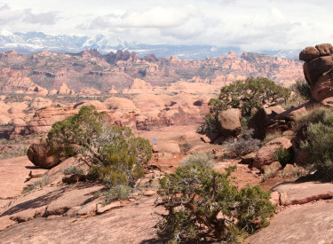
Panorama of four stitched frames looking across Salt Valley from the highest spot on Alaska.
This view extends from north to the southeast. From left to right, rock layers change from
Entrada (dark cliff-line mid-left) to Navajo (white band mid-photo) to Kayenta (darker layered
rock below Navajo) to Wingate. (brown cliffs above valley floor mid-right).

View northeast as we skirt a long patch of open rock on the Alaska Trail. Review by Bruce September 4, 2013. Latest update May 2018.
Alaska Trailwith Homer and Nome TrailsThe Alaska Trail was added to the
Klondike
Bluffs
trail system in 2013 as the northernmost trail. This group of mountain bike trails is located about 15
miles north of Moab, with a traditional trailhead on the south end and a
cluster of newer trailheads at the north end. The best access to the Alaska
Trail is either the Dinosaur Trackway trailhead or the Northern Klondike
trailhead. (See below.)
The riding is on singletrack and slickrock of the Morrison Formation from the late Jurassic
era. You'll briefly descend to the upper border of the Entrada, but most of the riding will
be on Salt Wash sandstone. The Alaska trail is upper-intermediate in tech requirement. Depending
on which route you take, there will be some hard climbing.
Riders do Alaska in either direction, about 50:50. You might prefer to climb all the way to
the top on Mega Steps (or another climbing route) and hit Alaska in the counterclockwise (downhill)
direction.

Trail view low on Alaska as we climb east uphill. Rolling sandstone with plenty of small ledges, and bits of dirt singletrack in between.

Mega Steps trail. From the Northern Klondike parking area, this is the route uphill to Alaska.
The Alaska trail itself is 4 miles long, but you have to ride other trails to get to it. The
smallest ride is 6.5 miles. This simple loop climbs
Mega Steps
to Alaska, then makes a loop (either direction) around Alaska and Mega Steps. See the map.
This route should be within the capability of an experienced intermediate rider.
The 2013 completion of the
Dino Flow
trail extension to the Dinosaur Trackway trailhead allows you to reach Alaska via Dino Flow.
This is a great option if the Mega Steps trailhead access is muddy. After starting on Dino
Flow, you can climb to Alaska via Homer, Nome or Mega Steps as you ride south on Dino Flow.

Kiosk at the Dinosaur Trackway. If you parked here, you can take Dino Flow south then take one of three connecting trails uphill to Alaska.

The Alaska Trail twists through a field of Salt Wash sandstone boulders.
Two other trails are intimately tied to Alaska. The Homer Trail starts uphill from Dino Flow
just south of the Dinosaur Trackway trailhead and climbs uphill 250 vertical feet in 0.8 miles.
It reaches Alaska just as that trail begins to get serious about heading uphill. That route
is the fastest way uphill.
The Nome Trail also starts on Dino Flow, about half-way from the trackway to Mega Steps. It
also climbs quickly to Alaska, but crosses and keeps going uphill for a little loop of technical
rock riding. Most riders would probably choose to use upper Nome as a side trip while doing
the main Alaska loop. See the ride description below.(You do know that Homer and Nome are towns in Alaska, right? Just checking.)

Second intersection with Nome when riding clockwise. Nome joins from uphill, then forks away downhill 100 feet later.

The trail curves around a bluff above the exposed top of the Entrada sandstone layer.
The Alaska Trail offers a lot of reasons to ride it. There's a lot of tight swooping desert
singletrack. There's miles of slickrock. With the other trails in the area --
Mega Steps
,
EKG
,
Dino Flow
,
Baby
Steps
, and
Little Salty
-- you can put together a monster ride. Thirty, forty miles? No problem.
Alaska provides solid intermediate riding. It's not as technical and bumpy as, for example,
EKG. The slickrock flows well with few tech challenges. The trail is marked with teal-colored
paint stripes. Every intersection is well-marked and easy to figure out.

Interesting spot. The trail climbs a narrow corridor of tiger-striped sandstone with cliff on both sides. See the video!

We're near the top of the mountain, looking west. We started in the little gray stripe of valley.
On the way up, you'll be treated to views to the west toward the Blue Hills. But once you reach
the ridgeline... Wow.
At the ridge, the trail overlooks Salt Valley to the northeast. The trail undulates along the
ridge, returning to the view again and again. The ridgeline ride is fun stuff on superbly well-built
trail.
The trail ends where Mega Steps reaches the ridgeline. You can turn and
descend
Mega Steps
, or keep riding the
ridgeline toward
Baby Steps
or
Little
Salty
. Lots of possibilities.

View northeast from the ridgeline. The reddish-brown top layer in mid-photo is Entrada. Navajo is the white layer underneath. Next are layers within the Kayenta formation.

Route map
The basic Alaska Loop starts from
Mega Steps
at the Northern Klondike trailhead. It's 6.5 miles long with 1100 vertical feet of climbing.
Top altitude is 5300 feet. It's upper-intermediate in technical requirement.
Climb Mega Steps. As you reach slickrock, keep straight uphill as
Dino Flow
joins on your left then leaves on your right. Climb another 1/4 mile. At the next intersection,
EKG
ends on your right as Mega Steps continues straight ahead. (For a counter-clockwise loop, keep
straight.) Fork to the right on Alaska for a clockwise loop.

The trail is marked with teal-green stripes. (The paint color varies a little, and is darker on the higher mountain).

Often after completing a climb, the trail will descend into a valley and head back west to catch the next finger of the escarpment.
Stay on Alaska as Nome forks away uphill on your right. A bit later, Nome will rejoin on your
right for 100 feet, then split downhill to your left. Keep on Alaska. The trail will meander,
gaining and losing altitude before you reach the Homer fork. Keep right and begin some serious
climbing.
The trail will climb a narrow band of slickrock. Stop to take in the view. Now keep climbing
as you again hit dirt and Salt Wash sandstone. At the rim, the trail will turn to the right.
Again, take a break as you admire the cliffs across Salt Valley.

Looking back to the northwest from a long slickrock ramp near the top.

Just a cool spot along the ridge. The trail makes an S turn through these boulders. In the background are the cliffs above Salt Valley.
There's some fun riding along the ridge until, all too soon, you reach the junction with Mega
Steps.
Mega Steps is a fast and fun downhill, interrupted by a brief climb up and over a dirt ridgeline.
You'll skirt another broad expanse of Entrada sandstone peeking up through the red dirt. (There
are three of these exposed spots, which all tend to look alike. But you're not in the same
valley you crossed before.) Now fly back to the trailhead.

And we're heading downhill on Mega Steps.
Riding notes for Alaska Loop:
0.0 N. Klondike TH, east on Mega Steps
N38 49.179 W109 45.422
0.3 Keep L, then R uphill on Mega Steps
(Cross Dino Flow) N38 49.351 W109 45.184
0.5 L on Alaska N38 49.421 W109 45.037
0.7 Keep L on Alaska (R=Nome)
N38 49.581 W109 45.013
0.9 Stay on Alaska N38 49.730 W109 45.101
Keep L, 100 feet, then R
2.2 R on Alaska (L=Homer)
N38 50.147 W109 45.369
3.3 Top of ridge
4.4 R downhill on Mega Steps
N38 50.098 W109 44.216
6.1 Keep straight N38 49.420 W109 45.037
Cross EKG/Alaska
6.3 Keep straight (cross Dino Flow)
N38 49.353 W109 45.171
6.6 Back at parking
Sample Ride:
Alaska
with visit to Nome

Route map
This loop follows the basic Alaska Loop, but detours onto Nome. This adds over a mile of technical
riding, bringing the distance to 7.7 miles and the climbing total to 1400. The addition of
Nome puts the tech level into the advanced level.
You can do the loop either direction. I rode counterclockwise my first ride, then clockwise
the next time. I think Nome rides better in the clockwise direction, as it puts some very big
rock stunts on the downhill side.
First, get to the Mega Steps/Alaska intersection. You can take Dino Flow to Mega Steps from
the Trackway trailhead, or go up Mega Steps from the North Klondike parking. For the clockwise
ride, turn left on Alaska.

Typical trail view early on Alaska.

We're beginning the climb on Nome. The trail is marked with dark blue paint stripes.
Watch for a sign "Nome Exit" with blue paint stripes on the rock. If you're doing Nome counterclockwise,
turn to the right and follow those blue stripes. The trail will climb up a little dead-end
escarpment.
If your plan is to do Nome clockwise, continue up Alaska another half mile, then fork right
on Nome. You'll repeat this (relatively easy) half-mile when you finish Nome.
There are some stretches of advanced technical riding here, but nothing too hairy. Plenty of
time to see what's coming up and get ready for your move.

Spinning into a rock ramp. When going south-to-north, there are a couple of bumps that are steep enough to stop intermediates.

Nome approaches the edge of the cliff so it can hit the sweet spot of a ramp.
After flirting with the cliff edge, Nome turns back downhill and gets easier. After 1.4 miles
on Nome, you're back to Alaska, not too far from where you left. Fork to the right, then keep
right on Alaska in 100 feet as Nome drops down to Dino Flow.
You're now back on the standard Alaska loop as described above. The trail will meander a bit
before it reaches the Homer fork. Keep to the right and begin climbing.

Back on Alaska, heading uphill around the westernmost exposed slickrock patch.

A sweet climbing spot on the southbound ridgeline, converted to a rock ramp by the trailbuilders. Still a bit of a challenge to clean.
There's some fun stuff on the ridgeline. Some excellent rock-work allows you to ride right
along the top with great views in all directions.
When you reach the Mega Steps intersection, turn to the right downhill to complete the loop.
Or if your ride was just too short, keep left and ride on.

Heading downhill on Mega Steps, which is marked with pale green paint.
Riding notes for Alaska with Nome:
0.0 N. Klondike TH, east on Mega Steps
N38 49.179 W109 45.422
0.3 Keep L, then R uphill on Mega Steps
(Cross Dino Flow) N38 49.351 W109 45.184
0.5 L on Alaska N38 49.421 W109 45.037
0.7 Fork R to Nome
N38 49.581 W109 45.013
2.1 R on Alaska N38 49.730 W109 45.101
100 feet, then R to stay on
Alaska
3.4 R on Alaska (L=Homer)
N38 50.147 W109 45.369
4.5 Top of ridge
5.6 R downhill on Mega Steps
N38 50.098 W109 44.216
7.3 Keep straight N38 49.420 W109 45.037
Cross EKG/Alaska
7.5 Keep straight (cross Dino Flow)
N38 49.353 W109 45.171
7.7 Back at parking
Sample Ride:
North
Alaska
with Homer and Nome

Route map
This ride starts from the Dinosaur Trackway parking. From Dino Flow, it quickly starts uphill
on Homer, then connects to Alaska just as it begins its serious climbing. You'll go straight
up the mountain in less than two miles. Then on the descent down Mega Steps, you'll veer back
onto Alaska, then detour onto Nome to climb back uphill then drop down to Dino Flow. Total
distance is 7.7 miles, but it will feel like a significantly harder ride. Total climbing will
be 1450 feet.
From the kiosk at the Dinosaur Trackway, look south toward the pit toilet. Dino Flow starts
at the far left corner of the gravel area at the trail post. You might not notice the trail
if you don't approach the toilet area.
 of the pit toilet. Only 100 yards t...")
Look for this post to the east (uphill side) of the pit toilet. Only 100 yards to the slickrock.
 on Homer. This trail is marked with yellow-orange pai...")
We're heading uphill (east) on Homer. This trail is marked with yellow-orange paint.
After only 1/10 mile, turn left uphill on Homer. The trail is marked with yellow paint stripes.
The route is a fairly steady climb without much meandering.
Homer is almost all slickrock. You'll hit a bit of dirt just before the junction with Alaska.
Turn left on Alaska. The trail will curve around to an escarpment, which is your route to the
top.

It looks steep, but it's not even a granny-gear climb. Cogs to spare.

We're on the slickrock ramp of Alaska. Note the tiger-stripe rock surface. The riding area will get a bit narrower uphill.
Climb Alaska all the way to the top. Follow the ridge around to the Mega Steps intersection.
Take Mega Steps downhill. The first intersection you come to will be the EKG/Alaska crossing.
Fork right on Alaska and climb back uphill about 1/2 mile.

We're heading downhill on Mega Steps. No, this isn't the slickrock area we crossed on the way up. We're one valley over. And we'll cross over a ridge to a third slickrock patch.

We're on Nome. There's a bit of this roller-coaster stuff. If you stop, it's hard to find a smooth spot to click into your pedals again. Moral: keep going.
Now fork to the right on Nome. It's climbing time again.
After Nome curves around and returns to Alaska, fork right on the combined route. 100 feet
later, fork to the left to stay on Nome to continue the descent.(Or, take another lap by keeping straight on Alaska.)

Fun stuff on Nome.

This is the junction of Nome with Dino Flow, viewed looking north (from a spot south of the intersection).
Nome will descend steadily. As you see the desert approaching, you'll hit Dino Flow. Fork to
the right to return to parking.
Riding notes for Homer to Alaska with
Nome:
0.0 Dinosaur TH, south on Dino Flow
N38 49.800 W109 45.795
0.1 L uphill on Homer
N38 49.767 W109 45.713
0.9 L on Alaska
N38 50.147 W109 45.369
2.0 Top of ridge
3.1 R downhill on Mega Steps
N38 50.098 W109 44.216
4.8 R on Alaska N38 49.420 W109 45.037
5.0 Fork R to Nome
N38 49.581 W109 45.013
6.4 R N38 49.730 W109 45.101
100 feet, then L to resume Nome
6.9 R on Dino Flow
N38 49.471 W109 45.432
7.6 Straight (L=Homer)
7.7 Back at trailhead

Map of Klondike Bluffs riding area.
Northern Klondike TH: On Highway 191 8.5 miles
south of I-70 and 6.5 miles north of the southern Klondike Bluffs road
(about 5 miles north of the airport), watch for a "Northern
Klondike" sign at N38 49.504 W109 46.893. Turn east (toward the
sandstone bluff). Keep to the right as the road winds south around a small
hill. 1.2 miles from the highway as the road is heading east toward the
bluff, the
Chilcoot trailhead is on the right.
Now fork right on a fainter jeep road N38 49.103 W109 46.061, as the
main road continues to the dinosaur tracks. (Park here if the road is in
bad shape.) At mile 1.6, you'll come to the small parking spot for the
Jasper and Agate
loops (N38 49.087 W109 45.625) on your right. At 2.0 miles, you're at the
bottom of Mega Steps at a larger parking area N38 49.179 W109 45.417. To
reach Alaska, head uphill on
Mega Steps.
Dinosaur Tracks TH: At the trail fork at mile 1.2, keep left
on the main road toward the dinosaur tracks. About 1/2 mile further, turn
to the right into the parking area. The Dino Flow trail is up against the
mountain, to the left of the pit toilet. It will take you to Homer, then
to Nome, then to Mega Steps (which climbs to Alaska).
Southern Klondike TH: Starting at the Colorado River, drive
15 miles north from Moab. Look for a turnout with parking on the right and
a sign for Klondike Bluffs Road. There will
usually be cars parked there (GPS N 38° 44.452' W 109°
44.037'). For a longer ride, park here and ride up the road. Most cyclists will choose to go through the gate and drive 2.7 miles. Keep left at
the fork. At 2.8 miles, park your car in the broad parking area by the
fence. Go eastbound across the cattleguard through the fence and begin your
ride. To reach Alaska, you'll need to pedal several miles north on Copper
Ridge Road, Dino Flow, or EKG. Or, you can climb Baby Steps or Mega Steps
to reach the ridge and Alaska at the top.


 of the pit toilet. Only 100 yards t...")
 on Homer. This trail is marked with yellow-orange pai...")